

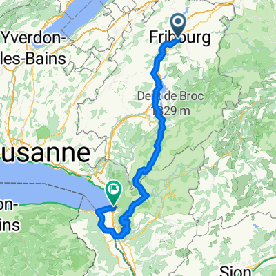
Fribourg-Morges
A cycling route starting in Fribourg, Canton of Fribourg, Switzerland.
Overview
About this route
Via Estavayer-le-Lac (route 34) / Yverdon (route 5) / Orbe (route 50) / Morges (route 5) /
- -:--
- Duration
- 109.3 km
- Distance
- 366 m
- Ascent
- 626 m
- Descent
- ---
- Avg. speed
- ---
- Max. altitude

Route quality
Waytypes & surfaces along the route
Waytypes
Quiet road
41.5 km
(38 %)
Track
29.5 km
(27 %)
Surfaces
Paved
60.1 km
(55 %)
Unpaved
14.2 km
(13 %)
Asphalt
33.9 km
(31 %)
Concrete
18.6 km
(17 %)
Route highlights
Points of interest along the route
Accommodation after 66.4 km
Camping TCS
Point of interest after 96.9 km
Attention: gravel in the forest.
Continue with Bikemap
Use, edit, or download this cycling route
You would like to ride Fribourg-Morges or customize it for your own trip? Here is what you can do with this Bikemap route:
Free features
- Save this route as favorite or in collections
- Copy & plan your own version of this route
- Split it into stages to create a multi-day tour
- Sync your route with Garmin or Wahoo
Premium features
Free trial for 3 days, or one-time payment. More about Bikemap Premium.
- Navigate this route on iOS & Android
- Export a GPX / KML file of this route
- Create your custom printout (try it for free)
- Download this route for offline navigation
Discover more Premium features.
Get Bikemap PremiumFrom our community
Other popular routes starting in Fribourg
 Rue de Zaehringen 2, Fribourg to Thunstrasse 40-42, Tafers
- Distance
- 11.3 km
- Ascent
- 184 m
- Descent
- 107 m
- Location
- Fribourg, Canton of Fribourg, Switzerland
 FR- Montagny Les Monts
- Distance
- 32 km
- Ascent
- 618 m
- Descent
- 622 m
- Location
- Fribourg, Canton of Fribourg, Switzerland
 Fribourg-Morges
- Distance
- 109.3 km
- Ascent
- 366 m
- Descent
- 626 m
- Location
- Fribourg, Canton of Fribourg, Switzerland
 FR-Guglera 57
- Distance
- 56.7 km
- Ascent
- 925 m
- Descent
- 927 m
- Location
- Fribourg, Canton of Fribourg, Switzerland
 FR-St Silverster-La Berra-La Roche - Fribourg
- Distance
- 59.3 km
- Ascent
- 1,391 m
- Descent
- 1,398 m
- Location
- Fribourg, Canton of Fribourg, Switzerland
 FR-Bulle-Allières-Hongrin-Corbeyrier-Villeneuve
- Distance
- 102.1 km
- Ascent
- 2,555 m
- Descent
- 2,787 m
- Location
- Fribourg, Canton of Fribourg, Switzerland
 Rund um den Murtensee inkl. Mont Vully (Fribourg-Mont Vully-Courtepin)
- Distance
- 51.6 km
- Ascent
- 2,123 m
- Descent
- 2,187 m
- Location
- Fribourg, Canton of Fribourg, Switzerland
 FR-Guglera 43
- Distance
- 42.6 km
- Ascent
- 785 m
- Descent
- 782 m
- Location
- Fribourg, Canton of Fribourg, Switzerland
Open it in the app