

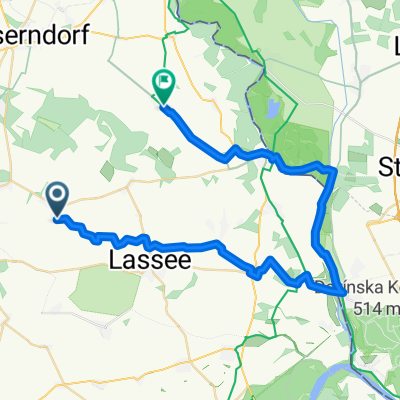
Bratislava TAG1
A cycling route starting in Untersiebenbrunn, Lower Austria, Austria.
Overview
About this route
- -:--
- Duration
- 48.7 km
- Distance
- 45 m
- Ascent
- 58 m
- Descent
- ---
- Avg. speed
- ---
- Max. altitude

Route quality
Waytypes & surfaces along the route
Waytypes
Road
13.6 km
(28 %)
Cycleway
12.7 km
(26 %)
Surfaces
Paved
40.9 km
(84 %)
Unpaved
5.4 km
(11 %)
Asphalt
39 km
(80 %)
Gravel
2.9 km
(6 %)
Route highlights
Points of interest along the route
Point of interest after 10.4 km
Point of interest after 23.5 km
Gasthaus Nagl
Point of interest after 36.7 km
Bier
Continue with Bikemap
Use, edit, or download this cycling route
You would like to ride Bratislava TAG1 or customize it for your own trip? Here is what you can do with this Bikemap route:
Free features
- Save this route as favorite or in collections
- Copy & plan your own version of this route
- Sync your route with Garmin or Wahoo
Premium features
Free trial for 3 days, or one-time payment. More about Bikemap Premium.
- Navigate this route on iOS & Android
- Export a GPX / KML file of this route
- Create your custom printout (try it for free)
- Download this route for offline navigation
Discover more Premium features.
Get Bikemap PremiumFrom our community
Other popular routes starting in Untersiebenbrunn
 Siebenbrunn-Leopoldsdorf - Bad Deutsch Altenburg
- Distance
- 33.1 km
- Ascent
- 111 m
- Descent
- 93 m
- Location
- Untersiebenbrunn, Lower Austria, Austria
 Bratislava TAG1
- Distance
- 48.7 km
- Ascent
- 45 m
- Descent
- 58 m
- Location
- Untersiebenbrunn, Lower Austria, Austria
 Wiesengasse 28, Untersiebenbrunn nach Wiesengasse 28, Untersiebenbrunn
- Distance
- 51.3 km
- Ascent
- 87 m
- Descent
- 131 m
- Location
- Untersiebenbrunn, Lower Austria, Austria
 Knackige Fahrt in Obersiebenbrunn
- Distance
- 21.7 km
- Ascent
- 50 m
- Descent
- 118 m
- Location
- Untersiebenbrunn, Lower Austria, Austria
 Untersiebenbrunn nach Oberweiden
- Distance
- 41.5 km
- Ascent
- 72 m
- Descent
- 60 m
- Location
- Untersiebenbrunn, Lower Austria, Austria
 Siebenbrunn-Leopoldsdorf - Marchegg-Bahnhof
- Distance
- 32.8 km
- Ascent
- 57 m
- Descent
- 61 m
- Location
- Untersiebenbrunn, Lower Austria, Austria
 Am Bahnhof, Obersiebenbrunn to Bahnhofstraße 14/2, Obersiebenbrunn
- Distance
- 6.9 km
- Ascent
- 62 m
- Descent
- 94 m
- Location
- Untersiebenbrunn, Lower Austria, Austria
 Bahnhofstraße 14/10, Obersiebenbrunn nach Bahnhofstraße 14/10, Obersiebenbrunn
- Distance
- 16 km
- Ascent
- 44 m
- Descent
- 44 m
- Location
- Untersiebenbrunn, Lower Austria, Austria
Open it in the app