
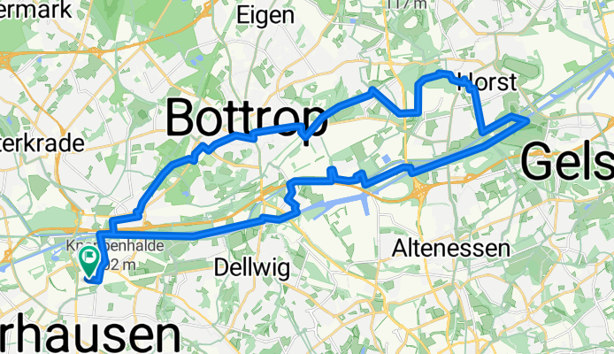
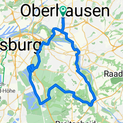
Oberhausen Bottrop Gelsenkirchen Oberhausen
A cycling route starting in Oberhausen, North Rhine-Westphalia, Germany.
Overview
About this route
Rundkurs von Oberhausen Neue Mitte über Bottrop und Gelsenkirchen bis zum Nordsternpark und zurück an der Emscher bis Neue Mitte.
- -:--
- Duration
- 34.9 km
- Distance
- 108 m
- Ascent
- 108 m
- Descent
- ---
- Avg. speed
- ---
- Avg. speed
Route quality
Waytypes & surfaces along the route
Waytypes
Path
17.1 km
(49 %)
Quiet road
7 km
(20 %)
Surfaces
Paved
19.3 km
(55 %)
Unpaved
12.2 km
(35 %)
Asphalt
14.7 km
(42 %)
Gravel
10.8 km
(31 %)
Continue with Bikemap
Use, edit, or download this cycling route
You would like to ride Oberhausen Bottrop Gelsenkirchen Oberhausen or customize it for your own trip? Here is what you can do with this Bikemap route:
Free features
- Save this route as favorite or in collections
- Copy & plan your own version of this route
- Sync your route with Garmin or Wahoo
Premium features
Free trial for 3 days, or one-time payment. More about Bikemap Premium.
- Navigate this route on iOS & Android
- Export a GPX / KML file of this route
- Create your custom printout (try it for free)
- Download this route for offline navigation
Discover more Premium features.
Get Bikemap PremiumFrom our community
Other popular routes starting in Oberhausen
 schöne Feierabendrunde
- Distance
- 37.4 km
- Ascent
- 200 m
- Descent
- 200 m
- Location
- Oberhausen, North Rhine-Westphalia, Germany
 Centro, Rotbach, Voerde, Walsum, Centro
- Distance
- 54 km
- Ascent
- 159 m
- Descent
- 167 m
- Location
- Oberhausen, North Rhine-Westphalia, Germany
 Centro - Amphiteater - Zollverein - Freibad Hesse - Gehölzgarten Ripshorst
- Distance
- 33.3 km
- Ascent
- 51 m
- Descent
- 48 m
- Location
- Oberhausen, North Rhine-Westphalia, Germany
 24 Haldentour vier Halden im Revier
- Distance
- 55.8 km
- Ascent
- 294 m
- Descent
- 294 m
- Location
- Oberhausen, North Rhine-Westphalia, Germany
 Hoheward
- Distance
- 60.8 km
- Ascent
- 333 m
- Descent
- 336 m
- Location
- Oberhausen, North Rhine-Westphalia, Germany
 Olga - Grafenmühle - Schermbeck - Weselerwald - Hünxe - Fridrichsfeld - Götterswickerham - Möllen - Pillekamp - Grafschaft - Schmachtendorf - Eisenheim
- Distance
- 95.4 km
- Ascent
- 184 m
- Descent
- 186 m
- Location
- Oberhausen, North Rhine-Westphalia, Germany
 HOAG-Trasse - Kleine Emscher
- Distance
- 40.1 km
- Ascent
- 96 m
- Descent
- 96 m
- Location
- Oberhausen, North Rhine-Westphalia, Germany
 Olga - Gahlen - Drevenack - Wesel - Orsoy
- Distance
- 88 km
- Ascent
- 144 m
- Descent
- 145 m
- Location
- Oberhausen, North Rhine-Westphalia, Germany
Open it in the app