

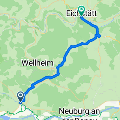
The Missing Link - Vom Urdonautal ins Ries
A cycling route starting in Rennertshofen, Bavaria, Germany.
Overview
About this route
Auf dieser Tour erlebt man mindestens 15 Mio. Jahre Erdgeschichte! Und beinahe ebenso viele Höhenmeter ;)
Vom Urdonautal schwingen wir uns hinüber an den Rand des Nördlinger Rieses bei Wemding. Zurück geht es dann noch welliger über Treuchtlingen und Pappenheim, wo wir uns dann endgültig der Obhut des Altmühltals anvertrauen.
Landschaftlich ein absoluter Hochgenuß. Non stop! Allerdings erfordert die Tour Einiges an Stehvermögen.
- -:--
- Duration
- 118.6 km
- Distance
- 552 m
- Ascent
- 553 m
- Descent
- ---
- Avg. speed
- ---
- Max. altitude
Route quality
Waytypes & surfaces along the route
Waytypes
Busy road
42.3 km
(36 %)
Quiet road
36 km
(30 %)
Surfaces
Paved
86.9 km
(73 %)
Unpaved
2.9 km
(2 %)
Asphalt
79.4 km
(67 %)
Paved (undefined)
7.4 km
(6 %)
Continue with Bikemap
Use, edit, or download this cycling route
You would like to ride The Missing Link - Vom Urdonautal ins Ries or customize it for your own trip? Here is what you can do with this Bikemap route:
Free features
- Save this route as favorite or in collections
- Copy & plan your own version of this route
- Split it into stages to create a multi-day tour
- Sync your route with Garmin or Wahoo
Premium features
Free trial for 3 days, or one-time payment. More about Bikemap Premium.
- Navigate this route on iOS & Android
- Export a GPX / KML file of this route
- Create your custom printout (try it for free)
- Download this route for offline navigation
Discover more Premium features.
Get Bikemap PremiumFrom our community
Other popular routes starting in Rennertshofen
 DO5 Neuburg - Kinding
- Distance
- 73.3 km
- Ascent
- 145 m
- Descent
- 161 m
- Location
- Rennertshofen, Bavaria, Germany
 Dohlenfelsenstraße 16, Wellheim nach St2047, Rennertshofen
- Distance
- 47.7 km
- Ascent
- 1,507 m
- Descent
- 1,504 m
- Location
- Rennertshofen, Bavaria, Germany
 Bertholzheim- Neuburg
- Distance
- 33.7 km
- Ascent
- 212 m
- Descent
- 212 m
- Location
- Rennertshofen, Bavaria, Germany
 Spndeltal Tour (2)
- Distance
- 27.3 km
- Ascent
- 121 m
- Descent
- 200 m
- Location
- Rennertshofen, Bavaria, Germany
 5aa Rennertshofen Bad Gogging 71km
- Distance
- 70.2 km
- Ascent
- 81 m
- Descent
- 120 m
- Location
- Rennertshofen, Bavaria, Germany
 Altmühl und Urdonau auf Abwegen
- Distance
- 100 km
- Ascent
- 765 m
- Descent
- 766 m
- Location
- Rennertshofen, Bavaria, Germany
 Bergstrecke Links oder rechts herum
- Distance
- 45.6 km
- Ascent
- 729 m
- Descent
- 703 m
- Location
- Rennertshofen, Bavaria, Germany
 Unbenannte Route
- Distance
- 27.3 km
- Ascent
- 315 m
- Descent
- 316 m
- Location
- Rennertshofen, Bavaria, Germany
Open it in the app