
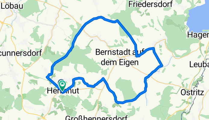
Rund um den Eigen
A cycling route starting in Herrnhut, Saxony, Germany.
Overview
About this route
Between Strahwalde and Buschschenke usually bad, otherwise a nice ride
- -:--
- Duration
- 36.9 km
- Distance
- 333 m
- Ascent
- 331 m
- Descent
- ---
- Avg. speed
- ---
- Max. altitude

Route quality
Waytypes & surfaces along the route
Waytypes
Road
10.7 km
(29 %)
Track
10.3 km
(28 %)
Surfaces
Paved
10.7 km
(29 %)
Unpaved
8.1 km
(22 %)
Asphalt
7 km
(19 %)
Unpaved (undefined)
6.6 km
(18 %)
Continue with Bikemap
Use, edit, or download this cycling route
You would like to ride Rund um den Eigen or customize it for your own trip? Here is what you can do with this Bikemap route:
Free features
- Save this route as favorite or in collections
- Copy & plan your own version of this route
- Sync your route with Garmin or Wahoo
Premium features
Free trial for 3 days, or one-time payment. More about Bikemap Premium.
- Navigate this route on iOS & Android
- Export a GPX / KML file of this route
- Create your custom printout (try it for free)
- Download this route for offline navigation
Discover more Premium features.
Get Bikemap PremiumFrom our community
Other popular routes starting in Herrnhut
 SSw-Ru-Jest-Libe-Ru
- Distance
- 124 km
- Ascent
- 1,175 m
- Descent
- 1,175 m
- Location
- Herrnhut, Saxony, Germany
 SSw-Ru-IsGb-Rei114
- Distance
- 114.1 km
- Ascent
- 1,261 m
- Descent
- 1,182 m
- Location
- Herrnhut, Saxony, Germany
 Berthelsdorf - Zittau - Ostritz
- Distance
- 51.4 km
- Ascent
- 390 m
- Descent
- 390 m
- Location
- Herrnhut, Saxony, Germany
 Sommerradtour 2020 (Etappe 2 : Herrnhut - Bautzen)
- Distance
- 55.1 km
- Ascent
- 186 m
- Descent
- 316 m
- Location
- Herrnhut, Saxony, Germany
 Flugplatz Bautzen
- Distance
- 79.5 km
- Ascent
- 543 m
- Descent
- 543 m
- Location
- Herrnhut, Saxony, Germany
 Ins Zittauer Gebirge
- Distance
- 61.8 km
- Ascent
- 549 m
- Descent
- 549 m
- Location
- Herrnhut, Saxony, Germany
 Ruppersdorf - Rothenburg
- Distance
- 64.6 km
- Ascent
- 143 m
- Descent
- 312 m
- Location
- Herrnhut, Saxony, Germany
 Leichte Tour Herrnhut Jetrichovice Dresden
- Distance
- 111.2 km
- Ascent
- 511 m
- Descent
- 721 m
- Location
- Herrnhut, Saxony, Germany
Open it in the app