

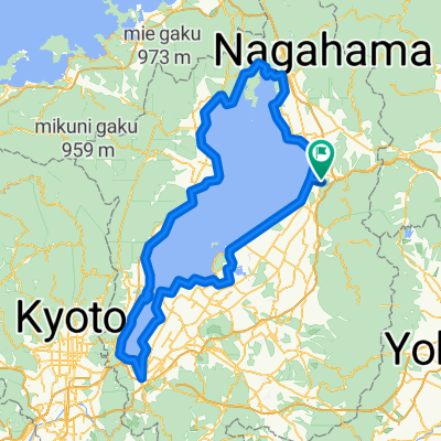
米原/道の駅 近江母の郷-ビワイチ右回り
A cycling route starting in Nagahama, Shiga Prefecture, Japan.
Overview
About this route
- -:--
- Duration
- 161.1 km
- Distance
- 211 m
- Ascent
- 210 m
- Descent
- ---
- Avg. speed
- ---
- Max. altitude

Route quality
Waytypes & surfaces along the route
Waytypes
Quiet road
25.8 km
(16 %)
Cycleway
20.9 km
(13 %)
Surfaces
Paved
59.6 km
(37 %)
Asphalt
30.6 km
(19 %)
Paved (undefined)
29 km
(18 %)
Undefined
101.5 km
(63 %)
Continue with Bikemap
Use, edit, or download this cycling route
You would like to ride 米原/道の駅 近江母の郷-ビワイチ右回り or customize it for your own trip? Here is what you can do with this Bikemap route:
Free features
- Save this route as favorite or in collections
- Copy & plan your own version of this route
- Split it into stages to create a multi-day tour
- Sync your route with Garmin or Wahoo
Premium features
Free trial for 3 days, or one-time payment. More about Bikemap Premium.
- Navigate this route on iOS & Android
- Export a GPX / KML file of this route
- Create your custom printout (try it for free)
- Download this route for offline navigation
Discover more Premium features.
Get Bikemap PremiumFrom our community
Other popular routes starting in Nagahama
 planA
planA- Distance
- 78.6 km
- Ascent
- 3,857 m
- Descent
- 3,919 m
- Location
- Nagahama, Shiga Prefecture, Japan
 Nagahama to Kyoto
- Distance
- 80.4 km
- Ascent
- 394 m
- Descent
- 425 m
- Location
- Nagahama, Shiga Prefecture, Japan
 長浜-ビワイチ(反時計回り)(312450)
- Distance
- 153.2 km
- Ascent
- 225 m
- Descent
- 225 m
- Location
- Nagahama, Shiga Prefecture, Japan
 ビワイチ2019
- Distance
- 201 km
- Ascent
- 1,508 m
- Descent
- 1,505 m
- Location
- Nagahama, Shiga Prefecture, Japan
 Easy ride
- Distance
- 85.5 km
- Ascent
- 71 m
- Descent
- 88 m
- Location
- Nagahama, Shiga Prefecture, Japan
 11月4日ビワイチ
- Distance
- 146.9 km
- Ascent
- 368 m
- Descent
- 368 m
- Location
- Nagahama, Shiga Prefecture, Japan
 2017/3/19
- Distance
- 114 km
- Ascent
- 549 m
- Descent
- 617 m
- Location
- Nagahama, Shiga Prefecture, Japan
 0822長濱-福井85km
- Distance
- 84.8 km
- Ascent
- 525 m
- Descent
- 618 m
- Location
- Nagahama, Shiga Prefecture, Japan
Open it in the app