Romantic Route (Wurzburg to Fussen)
RR6 Hohenwart to Fussen (Germany)
A cycling route starting in Vilgertshofen, Bavaria, Germany.
Overview
About this route
To end of the Romantic Route
- -:--
- Duration
- 73.1 km
- Distance
- 839 m
- Ascent
- 668 m
- Descent
- ---
- Avg. speed
- 890 m
- Max. altitude
Part of

Romantic Route (Wurzburg to Fussen)
11 stages
Route quality
Waytypes & surfaces along the route
Waytypes
Quiet road
44.6 km
(61 %)
Path
13.2 km
(18 %)
Surfaces
Paved
65 km
(89 %)
Unpaved
2.9 km
(4 %)
Asphalt
61.4 km
(84 %)
Paved (undefined)
3.7 km
(5 %)
Continue with Bikemap
Use, edit, or download this cycling route
You would like to ride RR6 Hohenwart to Fussen (Germany) or customize it for your own trip? Here is what you can do with this Bikemap route:
Free features
- Save this route as favorite or in collections
- Copy & plan your own version of this route
- Sync your route with Garmin or Wahoo
Premium features
Free trial for 3 days, or one-time payment. More about Bikemap Premium.
- Navigate this route on iOS & Android
- Export a GPX / KML file of this route
- Create your custom printout (try it for free)
- Download this route for offline navigation
Discover more Premium features.
Get Bikemap PremiumFrom our community
Other popular routes starting in Vilgertshofen
- D-V15-03 Fuchstal-Fuessen
- Distance
- 60.8 km
- Ascent
- 364 m
- Descent
- 211 m
- Location
- Vilgertshofen, Bavaria, Germany
- Bergstraße 27, Vilgertshofen nach Pössinger Au 1, Landsberg am Lech
- Distance
- 12.8 km
- Ascent
- 144 m
- Descent
- 143 m
- Location
- Vilgertshofen, Bavaria, Germany
- RR6 Hohenwart to Fussen (Germany)
- Distance
- 73.1 km
- Ascent
- 839 m
- Descent
- 668 m
- Location
- Vilgertshofen, Bavaria, Germany
- Emmering, Vilgertshofen nach Frauenwies 2, Vilgertshofen
- Distance
- 73.1 km
- Ascent
- 380 m
- Descent
- 377 m
- Location
- Vilgertshofen, Bavaria, Germany
- Planseerunde durchs Allgäu und die Alpen CLONED FROM ROUTE 967219
- Distance
- 694.6 km
- Ascent
- 1,792 m
- Descent
- 1,901 m
- Location
- Vilgertshofen, Bavaria, Germany
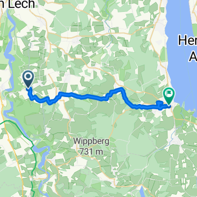
- Mundraching Lechtour 51km
- Distance
- 51.4 km
- Ascent
- 696 m
- Descent
- 696 m
- Location
- Vilgertshofen, Bavaria, Germany
- Straße ohne Straßennamen, Reichling nach Feichtmayrstraße 20, Wessobrunn
- Distance
- 25.1 km
- Ascent
- 706 m
- Descent
- 628 m
- Location
- Vilgertshofen, Bavaria, Germany
- Pizzaconnection
- Distance
- 25.6 km
- Ascent
- 274 m
- Descent
- 274 m
- Location
- Vilgertshofen, Bavaria, Germany
Open it in the app