Madeline Cruise
A cycling route starting in Washburn, Wisconsin, United States.
Overview
About this route
- -:--
- Duration
- 29.7 km
- Distance
- 105 m
- Ascent
- 105 m
- Descent
- ---
- Avg. speed
- ---
- Max. altitude
Route quality
Waytypes & surfaces along the route
Waytypes
Road
20 km
(67 %)
Quiet road
9.7 km
(33 %)
Undefined
-0 km
(<1 %)
Surfaces
Paved
29.6 km
(100 %)
Asphalt
29.5 km
(99 %)
Concrete
0.1 km
(<1 %)
Undefined
0.1 km
(<1 %)
Continue with Bikemap
Use, edit, or download this cycling route
You would like to ride Madeline Cruise or customize it for your own trip? Here is what you can do with this Bikemap route:
Free features
- Save this route as favorite or in collections
- Copy & plan your own version of this route
- Sync your route with Garmin or Wahoo
Premium features
Free trial for 3 days, or one-time payment. More about Bikemap Premium.
- Navigate this route on iOS & Android
- Export a GPX / KML file of this route
- Create your custom printout (try it for free)
- Download this route for offline navigation
Discover more Premium features.
Get Bikemap PremiumFrom our community
Other popular routes starting in Washburn
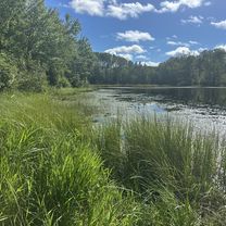
- Robert and Patricia ride to Long Lake and to the campground and back Washburn
- Distance
- 27.2 km
- Ascent
- 236 m
- Descent
- 235 m
- Location
- Washburn, Wisconsin, United States
- Washburn-Cornicopa-Bayfield Loop
- Distance
- 83.8 km
- Ascent
- 590 m
- Descent
- 592 m
- Location
- Washburn, Wisconsin, United States
- day_5
- Distance
- 19.4 km
- Ascent
- 136 m
- Descent
- 160 m
- Location
- Washburn, Wisconsin, United States
- Madeline Island bike ride with Micah
- Distance
- 6.7 km
- Ascent
- 63 m
- Descent
- 69 m
- Location
- Washburn, Wisconsin, United States
- 33026–33342 Burlager Rd, Washburn to 615 Lake Shore Dr W, Ashland
- Distance
- 23 km
- Ascent
- 91 m
- Descent
- 142 m
- Location
- Washburn, Wisconsin, United States
- Main St, La Pointe to Main St, La Pointe
- Distance
- 26.2 km
- Ascent
- 74 m
- Descent
- 72 m
- Location
- Washburn, Wisconsin, United States
- Patricia &Robert Ondossagon Rd, Washburn to Ondossagon Rd, Washburn
- Distance
- 11.3 km
- Ascent
- 172 m
- Descent
- 165 m
- Location
- Washburn, Wisconsin, United States
- Bayfield to Ino
- Distance
- 73.3 km
- Ascent
- 482 m
- Descent
- 385 m
- Location
- Washburn, Wisconsin, United States
Open it in the app