

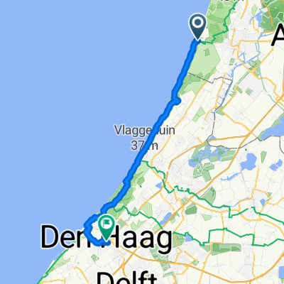
water leiding duinen
A cycling route starting in Zandvoort, North Holland, The Netherlands.
Overview
About this route
- 2 h 13 min
- Duration
- 11.1 km
- Distance
- 106 m
- Ascent
- 118 m
- Descent
- 5 km/h
- Avg. speed
- ---
- Max. altitude

Continue with Bikemap
Use, edit, or download this cycling route
You would like to ride water leiding duinen or customize it for your own trip? Here is what you can do with this Bikemap route:
Free features
- Save this route as favorite or in collections
- Copy & plan your own version of this route
- Sync your route with Garmin or Wahoo
Premium features
Free trial for 3 days, or one-time payment. More about Bikemap Premium.
- Navigate this route on iOS & Android
- Export a GPX / KML file of this route
- Create your custom printout (try it for free)
- Download this route for offline navigation
Discover more Premium features.
Get Bikemap PremiumFrom our community
Other popular routes starting in Zandvoort
 Kennemer duinen
- Distance
- 36.7 km
- Ascent
- 65 m
- Descent
- 66 m
- Location
- Zandvoort, North Holland, The Netherlands
 RIT.1 - Bloemendal-Grotewal
- Distance
- 82.6 km
- Ascent
- 227 m
- Descent
- 238 m
- Location
- Zandvoort, North Holland, The Netherlands
 Zandvoort - The Hague
- Distance
- 47.3 km
- Ascent
- 183 m
- Descent
- 184 m
- Location
- Zandvoort, North Holland, The Netherlands
 Zandvoort zoals het hoort
- Distance
- 44.6 km
- Ascent
- 83 m
- Descent
- 93 m
- Location
- Zandvoort, North Holland, The Netherlands
 Steady ride near Haarlem
- Distance
- 24.4 km
- Ascent
- 26 m
- Descent
- 28 m
- Location
- Zandvoort, North Holland, The Netherlands
 Nordsee-große Strandtour
- Distance
- 37.5 km
- Ascent
- 69 m
- Descent
- 68 m
- Location
- Zandvoort, North Holland, The Netherlands
 Untitled route
- Distance
- 29.5 km
- Ascent
- 56 m
- Descent
- 53 m
- Location
- Zandvoort, North Holland, The Netherlands
 Holandia3
- Distance
- 43.2 km
- Ascent
- 50 m
- Descent
- 56 m
- Location
- Zandvoort, North Holland, The Netherlands
Open it in the app