

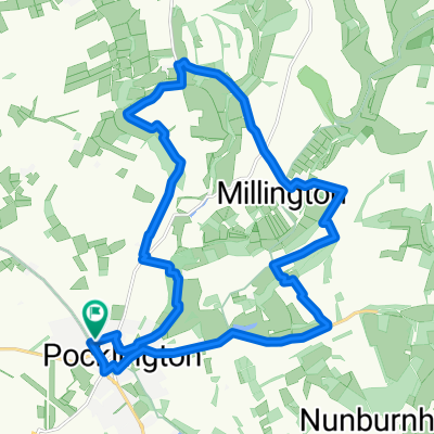
warter
A cycling route starting in Pocklington, England, United Kingdom.
Overview
About this route
- -:--
- Duration
- 44 km
- Distance
- 422 m
- Ascent
- 422 m
- Descent
- ---
- Avg. speed
- ---
- Max. altitude

Route quality
Waytypes & surfaces along the route
Waytypes
Quiet road
37.4 km
(85 %)
Road
4.8 km
(11 %)
Surfaces
Paved
17.6 km
(40 %)
Asphalt
17.6 km
(40 %)
Undefined
26.4 km
(60 %)
Continue with Bikemap
Use, edit, or download this cycling route
You would like to ride warter or customize it for your own trip? Here is what you can do with this Bikemap route:
Free features
- Save this route as favorite or in collections
- Copy & plan your own version of this route
- Sync your route with Garmin or Wahoo
Premium features
Free trial for 3 days, or one-time payment. More about Bikemap Premium.
- Navigate this route on iOS & Android
- Export a GPX / KML file of this route
- Create your custom printout (try it for free)
- Download this route for offline navigation
Discover more Premium features.
Get Bikemap PremiumFrom our community
Other popular routes starting in Pocklington
 Pocklington, Thixendale & Warter Loop
- Distance
- 39.9 km
- Ascent
- 342 m
- Descent
- 339 m
- Location
- Pocklington, England, United Kingdom
 43 Amos Drive, York to 43 Amos Drive, York
- Distance
- 19.3 km
- Ascent
- 0 m
- Descent
- 25 m
- Location
- Pocklington, England, United Kingdom
 Wolds Way - part
- Distance
- 57.6 km
- Ascent
- 360 m
- Descent
- 360 m
- Location
- Pocklington, England, United Kingdom
 Pock MTB Loop
- Distance
- 19.8 km
- Ascent
- 324 m
- Descent
- 324 m
- Location
- Pocklington, England, United Kingdom
 Pocklington circular
- Distance
- 27 km
- Ascent
- 51 m
- Descent
- 50 m
- Location
- Pocklington, England, United Kingdom
 huggate circular
- Distance
- 35.3 km
- Ascent
- 427 m
- Descent
- 421 m
- Location
- Pocklington, England, United Kingdom
 Pocklington circular
- Distance
- 60.3 km
- Ascent
- 357 m
- Descent
- 359 m
- Location
- Pocklington, England, United Kingdom
 Pocklington loop 6th May 2024
- Distance
- 27.9 km
- Ascent
- 84 m
- Descent
- 85 m
- Location
- Pocklington, England, United Kingdom
Open it in the app