
Biospharenpar Noekberge
A cycling route starting in Radenthein, Carinthia, Austria.
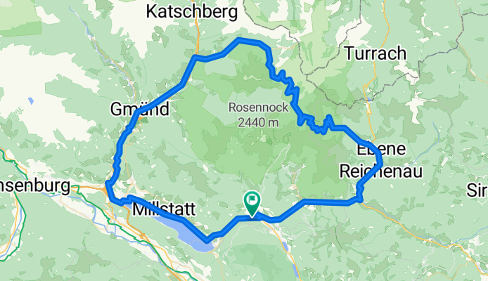
Overview
About this route
- -:--
- Duration
- 109.7 km
- Distance
- 1,935 m
- Ascent
- 1,935 m
- Descent
- ---
- Avg. speed
- ---
- Max. altitude

Route photos

Route quality
Waytypes & surfaces along the route
Waytypes
Busy road
36.5 km
(33 %)
Road
31.3 km
(29 %)
Surfaces
Paved
89.2 km
(81 %)
Unpaved
0.1 km
(<1 %)
Asphalt
87.7 km
(80 %)
Paved (undefined)
1.4 km
(1 %)
Continue with Bikemap
Use, edit, or download this cycling route
You would like to ride Biospharenpar Noekberge or customize it for your own trip? Here is what you can do with this Bikemap route:
Free features
- Save this route as favorite or in collections
- Copy & plan your own version of this route
- Split it into stages to create a multi-day tour
- Sync your route with Garmin or Wahoo
Premium features
Free trial for 3 days, or one-time payment. More about Bikemap Premium.
- Navigate this route on iOS & Android
- Export a GPX / KML file of this route
- Create your custom printout (try it for free)
- Download this route for offline navigation
Discover more Premium features.
Get Bikemap PremiumFrom our community
Other popular routes starting in Radenthein
 Döbriach - Radentheiner Kreuz
- Distance
- 12.6 km
- Ascent
- 1,297 m
- Descent
- 39 m
- Location
- Radenthein, Carinthia, Austria
 3 Hütten
- Distance
- 17.4 km
- Ascent
- 1,303 m
- Descent
- 30 m
- Location
- Radenthein, Carinthia, Austria
 St. Peter-Messnerwirt Hütte_-BKK
- Distance
- 58.7 km
- Ascent
- 1,109 m
- Descent
- 1,109 m
- Location
- Radenthein, Carinthia, Austria
 Biospharenpar Noekberge
- Distance
- 109.7 km
- Ascent
- 1,935 m
- Descent
- 1,935 m
- Location
- Radenthein, Carinthia, Austria
 St.Peter-Arriach-Werschling-Hochrindel-St.Peter
- Distance
- 82.2 km
- Ascent
- 2,181 m
- Descent
- 2,145 m
- Location
- Radenthein, Carinthia, Austria
 Rund um den Millstätter See
- Distance
- 53 km
- Ascent
- 1,431 m
- Descent
- 1,429 m
- Location
- Radenthein, Carinthia, Austria
 Kaning
- Distance
- 39.9 km
- Ascent
- 1,205 m
- Descent
- 1,621 m
- Location
- Radenthein, Carinthia, Austria
 St. Peter - Egelsee - Spittal - St. Peter
- Distance
- 56.3 km
- Ascent
- 663 m
- Descent
- 941 m
- Location
- Radenthein, Carinthia, Austria
Open it in the app