

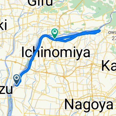
Slow ride in Ichinomiya-Shi
A cycling route starting in Sobue, Aichi, Japan.
Overview
About this route
- 1 h 6 min
- Duration
- 72.6 km
- Distance
- 139 m
- Ascent
- 135 m
- Descent
- 66.1 km/h
- Avg. speed
- ---
- Max. altitude

Route photos


Route quality
Waytypes & surfaces along the route
Waytypes
Quiet road
31.2 km
(43 %)
Cycleway
24.7 km
(34 %)
Surfaces
Paved
8.7 km
(12 %)
Paved (undefined)
5.1 km
(7 %)
Asphalt
3.6 km
(5 %)
Undefined
63.9 km
(88 %)
Continue with Bikemap
Use, edit, or download this cycling route
You would like to ride Slow ride in Ichinomiya-Shi or customize it for your own trip? Here is what you can do with this Bikemap route:
Free features
- Save this route as favorite or in collections
- Copy & plan your own version of this route
- Sync your route with Garmin or Wahoo
Premium features
Free trial for 3 days, or one-time payment. More about Bikemap Premium.
- Navigate this route on iOS & Android
- Export a GPX / KML file of this route
- Create your custom printout (try it for free)
- Download this route for offline navigation
Discover more Premium features.
Get Bikemap PremiumFrom our community
Other popular routes starting in Sobue
 Kyoto - Kurobe (Revised route)
- Distance
- 302.6 km
- Ascent
- 1,398 m
- Descent
- 1,392 m
- Location
- Sobue, Aichi, Japan
 京都→東京(Day1)
- Distance
- 169.7 km
- Ascent
- 1,823 m
- Descent
- 1,804 m
- Location
- Sobue, Aichi, Japan
 Kaizuchokusaba, Kaizu to 1106, Hiratachosango, Kaizu
- Distance
- 6.2 km
- Ascent
- 10 m
- Descent
- 7 m
- Location
- Sobue, Aichi, Japan
 240, Takehanacho Iigara, Hashima to Naegi, Nakatsugawa
- Distance
- 84.7 km
- Ascent
- 691 m
- Descent
- 287 m
- Location
- Sobue, Aichi, Japan
 Moderate route in Ichinomiya-Shi
- Distance
- 44.9 km
- Ascent
- 101 m
- Descent
- 90 m
- Location
- Sobue, Aichi, Japan
 Slow ride in Ichinomiya-Shi
- Distance
- 0.6 km
- Ascent
- 0 m
- Descent
- 0 m
- Location
- Sobue, Aichi, Japan
 Recovered Route
- Distance
- 10.7 km
- Ascent
- 525 m
- Descent
- 116 m
- Location
- Sobue, Aichi, Japan
 Slow ride in Ichinomiya-Shi
- Distance
- 72.6 km
- Ascent
- 139 m
- Descent
- 135 m
- Location
- Sobue, Aichi, Japan
Open it in the app