

Around Nice
Eze and back
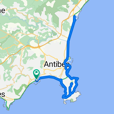
A cycling route starting in Vallauris, Provence-Alpes-Côte d'Azur Region, France.
Overview
About this route
- -:--
- Duration
- 82.8 km
- Distance
- 606 m
- Ascent
- 605 m
- Descent
- ---
- Avg. speed
- ---
- Max. altitude

Part of
Around Nice
4 stages
Route quality
Waytypes & surfaces along the route
Waytypes
Cycleway
18.2 km
(22 %)
Road
9.9 km
(12 %)
Surfaces
Paved
69.6 km
(84 %)
Unpaved
2.5 km
(3 %)
Asphalt
66.3 km
(80 %)
Concrete
3.3 km
(4 %)
Continue with Bikemap
Use, edit, or download this cycling route
You would like to ride Eze and back or customize it for your own trip? Here is what you can do with this Bikemap route:
Free features
- Save this route as favorite or in collections
- Copy & plan your own version of this route
- Split it into stages to create a multi-day tour
- Sync your route with Garmin or Wahoo
Premium features
Free trial for 3 days, or one-time payment. More about Bikemap Premium.
- Navigate this route on iOS & Android
- Export a GPX / KML file of this route
- Create your custom printout (try it for free)
- Download this route for offline navigation
Discover more Premium features.
Get Bikemap PremiumFrom our community
Other popular routes starting in Vallauris
 Long ride through Vallauris
- Distance
- 40.2 km
- Ascent
- 101 m
- Descent
- 103 m
- Location
- Vallauris, Provence-Alpes-Côte d'Azur Region, France
 Cannes Loop
- Distance
- 38 km
- Ascent
- 341 m
- Descent
- 342 m
- Location
- Vallauris, Provence-Alpes-Côte d'Azur Region, France
 Antibes - Auribeau
- Distance
- 43 km
- Ascent
- 436 m
- Descent
- 435 m
- Location
- Vallauris, Provence-Alpes-Côte d'Azur Region, France
 Mougins Le Haut to Nice
- Distance
- 84.4 km
- Ascent
- 604 m
- Descent
- 604 m
- Location
- Vallauris, Provence-Alpes-Côte d'Azur Region, France
 Mougins Le Haut to Cannes
- Distance
- 15.1 km
- Ascent
- 305 m
- Descent
- 307 m
- Location
- Vallauris, Provence-Alpes-Côte d'Azur Region, France
 monaco
- Distance
- 88.8 km
- Ascent
- 710 m
- Descent
- 710 m
- Location
- Vallauris, Provence-Alpes-Côte d'Azur Region, France
 Encordoules
- Distance
- 23.4 km
- Ascent
- 381 m
- Descent
- 381 m
- Location
- Vallauris, Provence-Alpes-Côte d'Azur Region, France
 golf juan-tanneron-grasse-golf juan
- Distance
- 87.9 km
- Ascent
- 994 m
- Descent
- 994 m
- Location
- Vallauris, Provence-Alpes-Côte d'Azur Region, France
Open it in the app