

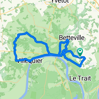
Boucle 50 km
A cycling route starting in Sainte-Marguerite-sur-Duclair, Normandy, France.
Overview
About this route
- -:--
- Duration
- 50.4 km
- Distance
- 340 m
- Ascent
- 342 m
- Descent
- ---
- Avg. speed
- ---
- Max. altitude

Route quality
Waytypes & surfaces along the route
Waytypes
Road
21.3 km
(42 %)
Quiet road
13.2 km
(26 %)
Surfaces
Paved
37.1 km
(74 %)
Asphalt
37.1 km
(74 %)
Concrete
0 km
(<1 %)
Undefined
13.3 km
(26 %)
Continue with Bikemap
Use, edit, or download this cycling route
You would like to ride Boucle 50 km or customize it for your own trip? Here is what you can do with this Bikemap route:
Free features
- Save this route as favorite or in collections
- Copy & plan your own version of this route
- Sync your route with Garmin or Wahoo
Premium features
Free trial for 3 days, or one-time payment. More about Bikemap Premium.
- Navigate this route on iOS & Android
- Export a GPX / KML file of this route
- Create your custom printout (try it for free)
- Download this route for offline navigation
Discover more Premium features.
Get Bikemap PremiumFrom our community
Other popular routes starting in Sainte-Marguerite-sur-Duclair
 Circuit VTT essai
- Distance
- 20.9 km
- Ascent
- 232 m
- Descent
- 231 m
- Location
- Sainte-Marguerite-sur-Duclair, Normandy, France
 Glatigny Villognon 2023
- Distance
- 500.1 km
- Ascent
- 2,720 m
- Descent
- 2,757 m
- Location
- Sainte-Marguerite-sur-Duclair, Normandy, France
 Ste Marguerite sur Duclair à Léry-Poses
- Distance
- 57.1 km
- Ascent
- 350 m
- Descent
- 441 m
- Location
- Sainte-Marguerite-sur-Duclair, Normandy, France
 Ballade 40km VTT
- Distance
- 40.3 km
- Ascent
- 671 m
- Descent
- 659 m
- Location
- Sainte-Marguerite-sur-Duclair, Normandy, France
 VTT 30km Jumièges
- Distance
- 29.2 km
- Ascent
- 378 m
- Descent
- 385 m
- Location
- Sainte-Marguerite-sur-Duclair, Normandy, France
 Balade Jules
- Distance
- 24.2 km
- Ascent
- 212 m
- Descent
- 217 m
- Location
- Sainte-Marguerite-sur-Duclair, Normandy, France
 Essai OSM modifs
- Distance
- 8.1 km
- Ascent
- 140 m
- Descent
- 138 m
- Location
- Sainte-Marguerite-sur-Duclair, Normandy, France
 Gravel 1
- Distance
- 45.9 km
- Ascent
- 467 m
- Descent
- 476 m
- Location
- Sainte-Marguerite-sur-Duclair, Normandy, France
Open it in the app