

B2B00401 55106>55454 via WheelockPkwy/Como/IntercampusTrail/27SE/Franklin/Riverside
A cycling route starting in Maplewood, Minnesota, United States.
Overview
About this route
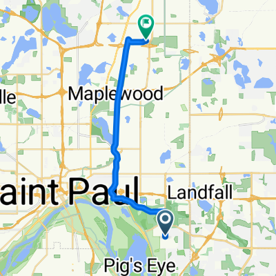
Take Johnson Pkwy north to Lake Phalen where it becomes Wheelock Pkwy. Follow Wheelock Pkwy. across 35E and Rice Street. After Rice Street there is a big curving hill up and around. Continue on Wheelock until you reach Lake Como. At Como turn left and continue around the Lake to W. Horton Av. Follow Horton to Lexington Pkwy. Go straight ahead as the road becomes Como Avenue at Hamiline. Follow Como Avenue past the State Fair Grounds until you reach the Intercampus Trailway. Turn left at the Trailway and continue up over the bridge in the road. At Energy Park Drive you can either stay in the road or ride on the bike path. Continue on until you reach 29th AvSE. Turn left one block to 4th St.SE/ Turn right on 4th St. to 27th AvSE. Turn left and continue on 27th AvSE across University Av. to the Franklin Bridge. Cross the Franklin Bridge and follow Franklin Av. to Riverside Av. Turn right at Riverside. After crossing over I94 Turn left on to Butler Pl. Follow Butler Place to 23rd Av. S and turn right to Augsburg College.
- -:--
- Duration
- 19.1 km
- Distance
- 69 m
- Ascent
- 71 m
- Descent
- ---
- Avg. speed
- 286 m
- Max. altitude
Route quality
Waytypes & surfaces along the route
Waytypes
Road
11.8 km
(62 %)
Cycleway
4.8 km
(25 %)
Surfaces
Paved
12.6 km
(66 %)
Asphalt
11.5 km
(60 %)
Concrete
0.8 km
(4 %)
Continue with Bikemap
Use, edit, or download this cycling route
You would like to ride B2B00401 55106>55454 via WheelockPkwy/Como/IntercampusTrail/27SE/Franklin/Riverside or customize it for your own trip? Here is what you can do with this Bikemap route:
Free features
- Save this route as favorite or in collections
- Copy & plan your own version of this route
- Sync your route with Garmin or Wahoo
Premium features
Free trial for 3 days, or one-time payment. More about Bikemap Premium.
- Navigate this route on iOS & Android
- Export a GPX / KML file of this route
- Create your custom printout (try it for free)
- Download this route for offline navigation
Discover more Premium features.
Get Bikemap PremiumFrom our community
Other popular routes starting in Maplewood
 Mississippi River Trail: Maplewood to Columbia Heights
- Distance
- 35.3 km
- Ascent
- 256 m
- Descent
- 222 m
- Location
- Maplewood, Minnesota, United States
 B2B00401 55106>55454 via WheelockPkwy/Como/IntercampusTrail/27SE/Franklin/Riverside
- Distance
- 19.1 km
- Ascent
- 69 m
- Descent
- 71 m
- Location
- Maplewood, Minnesota, United States
 B2B00784 55125>55164 via Up.Afton/Ruth/Mhaha/JohnsonPkwy/Wheelock/Edgerton/VadLake/Rice/Gramsie/Lex
- Distance
- 27.1 km
- Ascent
- 127 m
- Descent
- 137 m
- Location
- Maplewood, Minnesota, United States
 B2B00576 55119>55110 via Upper Afton Rd, Johnson Pkwy, Bruce Vento Trl
- Distance
- 17.1 km
- Ascent
- 74 m
- Descent
- 100 m
- Location
- Maplewood, Minnesota, United States
 B2B00758 55119>55128 viaUpperAfton/Century/HudsonRd./Hadley Hudson
- Distance
- 13.8 km
- Ascent
- 91 m
- Descent
- 78 m
- Location
- Maplewood, Minnesota, United States
 B2B00182 55106 > 55101 vie Johnson Pkwy., Hudson, Kellogg
- Distance
- 6.5 km
- Ascent
- 46 m
- Descent
- 80 m
- Location
- Maplewood, Minnesota, United States
 B2B00211 55119>55101 via Upper Afton, 7th Street
- Distance
- 17.8 km
- Ascent
- 189 m
- Descent
- 192 m
- Location
- Maplewood, Minnesota, United States
 Maplewood Cycling
- Distance
- 14.1 km
- Ascent
- 450 m
- Descent
- 299 m
- Location
- Maplewood, Minnesota, United States
Open it in the app