

Overview
About this route
- -:--
- Duration
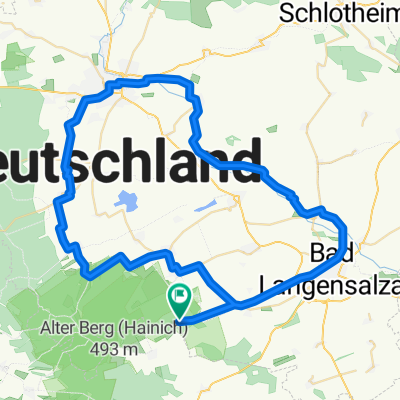
- 25.1 km
- Distance
- 321 m
- Ascent
- 320 m
- Descent
- ---
- Avg. speed
- ---
- Max. altitude

Part of
Hainich/Thüringen
8 stages
Route quality
Waytypes & surfaces along the route
Waytypes
Track
19.9 km
(79 %)
Quiet road
2.8 km
(11 %)
Surfaces
Paved
4.5 km
(18 %)
Unpaved
18.3 km
(73 %)
Gravel
16.8 km
(67 %)
Asphalt
3 km
(12 %)
Continue with Bikemap
Use, edit, or download this cycling route
You would like to ride Hainich Rundweg or customize it for your own trip? Here is what you can do with this Bikemap route:
Free features
- Save this route as favorite or in collections
- Copy & plan your own version of this route
- Sync your route with Garmin or Wahoo
Premium features
Free trial for 3 days, or one-time payment. More about Bikemap Premium.
- Navigate this route on iOS & Android
- Export a GPX / KML file of this route
- Create your custom printout (try it for free)
- Download this route for offline navigation
Discover more Premium features.
Get Bikemap PremiumFrom our community
Other popular routes starting in Weberstedt
 2015 Nationalpark Hanisch Zimmern,Grumbach,Craula
- Distance
- 28.6 km
- Ascent
- 343 m
- Descent
- 338 m
- Location
- Weberstedt, Thuringia, Germany
 TH-Hainich ab Craula
- Distance
- 16.9 km
- Ascent
- 350 m
- Descent
- 350 m
- Location
- Weberstedt, Thuringia, Germany
 Hainich-Bad Langensalza-Unstrut
- Distance
- 64.6 km
- Ascent
- 0 m
- Descent
- 344 m
- Location
- Weberstedt, Thuringia, Germany
 Thiemsburg-Mihla-Creuzburg
- Distance
- 52.8 km
- Ascent
- 648 m
- Descent
- 649 m
- Location
- Weberstedt, Thuringia, Germany
 2015 Nationalpark Hainisch
- Distance
- 58.2 km
- Ascent
- 498 m
- Descent
- 498 m
- Location
- Weberstedt, Thuringia, Germany
 Thiemsburg-Eisenach: Version 3
- Distance
- 62.5 km
- Ascent
- 0 m
- Descent
- 343 m
- Location
- Weberstedt, Thuringia, Germany
 Radtour 2016 MHL-Erfurt
- Distance
- 50.9 km
- Ascent
- 148 m
- Descent
- 380 m
- Location
- Weberstedt, Thuringia, Germany
 Thiemsburg-Bad Langensalza-Stadtbesuch
- Distance
- 21 km
- Ascent
- 579 m
- Descent
- 581 m
- Location
- Weberstedt, Thuringia, Germany
Open it in the app