

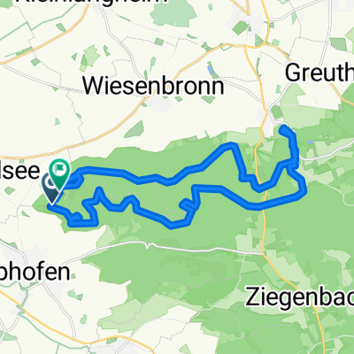
SCF Frankentour 2 Scheinfeld
A cycling route starting in Rödelsee, Bavaria, Germany.
Overview
About this route
Great tour for people who like to ride fast. Not very technically demanding. In the opposite direction, it's technically more interesting.
- -:--
- Duration
- 67.5 km
- Distance
- 598 m
- Ascent
- 598 m
- Descent
- ---
- Avg. speed
- ---
- Max. altitude
Route quality
Waytypes & surfaces along the route
Waytypes
Track
45.2 km
(67 %)
Road
8.8 km
(13 %)
Surfaces
Paved
21.6 km
(32 %)
Unpaved
38.5 km
(57 %)
Gravel
18.9 km
(28 %)
Ground
18.9 km
(28 %)
Continue with Bikemap
Use, edit, or download this cycling route
You would like to ride SCF Frankentour 2 Scheinfeld or customize it for your own trip? Here is what you can do with this Bikemap route:
Free features
- Save this route as favorite or in collections
- Copy & plan your own version of this route
- Sync your route with Garmin or Wahoo
Premium features
Free trial for 3 days, or one-time payment. More about Bikemap Premium.
- Navigate this route on iOS & Android
- Export a GPX / KML file of this route
- Create your custom printout (try it for free)
- Download this route for offline navigation
Discover more Premium features.
Get Bikemap PremiumFrom our community
Other popular routes starting in Rödelsee
 SCF Frankentour 2 Scheinfeld
- Distance
- 67.5 km
- Ascent
- 598 m
- Descent
- 598 m
- Location
- Rödelsee, Bavaria, Germany
 Von Rödelsee bis Würzburg
- Distance
- 28.3 km
- Ascent
- 225 m
- Descent
- 267 m
- Location
- Rödelsee, Bavaria, Germany
 Wanderweg: Naturpark Steigerwald, Blaues Dreieck (Rödelsee-Weingartsgreuth)
- Distance
- 43.6 km
- Ascent
- 633 m
- Descent
- 571 m
- Location
- Rödelsee, Bavaria, Germany
 Schwanberg - Castell
- Distance
- 25.4 km
- Ascent
- 412 m
- Descent
- 403 m
- Location
- Rödelsee, Bavaria, Germany
 Mainschleife
- Distance
- 72.3 km
- Ascent
- 402 m
- Descent
- 403 m
- Location
- Rödelsee, Bavaria, Germany
 Reupelsdorf - Rödelsee
- Distance
- 12.2 km
- Ascent
- 49 m
- Descent
- 71 m
- Location
- Rödelsee, Bavaria, Germany
 Kleine Schwanbergtour
- Distance
- 9.2 km
- Ascent
- 341 m
- Descent
- 341 m
- Location
- Rödelsee, Bavaria, Germany
 Roedelsee_Iphofen_Mainbernheim
- Distance
- 39.3 km
- Ascent
- 358 m
- Descent
- 358 m
- Location
- Rödelsee, Bavaria, Germany
Open it in the app