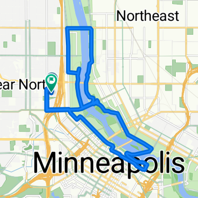
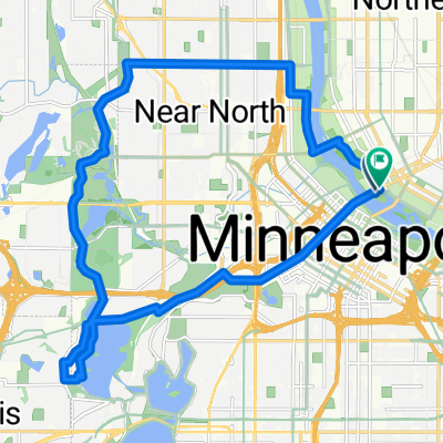
B2B00438 55402>55416 via Cedar Lake Trl, Cedar Lake Pkwy, Wayzata Blvd
A cycling route starting in Minneapolis, Minnesota, United States.
Overview
About this route
12th St will take you to the intersection of Royalston and Glenwood where you will get on the Cedar Lake Trail.
Â
Get off the trail at Cedar Lake Rd, which will take you to a bike path that follows Cedar Lake Pkwy.
Â
On the return trip, you can take Glenwood to N 10th St to Marquette.
- -:--
- Duration
- 8.5 km
- Distance
- 108 m
- Ascent
- 100 m
- Descent
- ---
- Avg. speed
- ---
- Max. altitude
Route highlights
Points of interest along the route
Point of interest after 1 km
Access to Cedar Lake Trl.
Point of interest after 5.5 km
Exit to Cedar Lake Rd
Continue with Bikemap
Use, edit, or download this cycling route
You would like to ride B2B00438 55402>55416 via Cedar Lake Trl, Cedar Lake Pkwy, Wayzata Blvd or customize it for your own trip? Here is what you can do with this Bikemap route:
Free features
- Save this route as favorite or in collections
- Copy & plan your own version of this route
- Sync your route with Garmin or Wahoo
Premium features
Free trial for 3 days, or one-time payment. More about Bikemap Premium.
- Navigate this route on iOS & Android
- Export a GPX / KML file of this route
- Create your custom printout (try it for free)
- Download this route for offline navigation
Discover more Premium features.
Get Bikemap PremiumFrom our community
Other popular routes starting in Minneapolis
- TCAC Cedar Lake Loop
- Distance
- 15.9 km
- Ascent
- 55 m
- Descent
- 54 m
- Location
- Minneapolis, Minnesota, United States
- 34 Spruce Pl, Minneapolis to Loring Park, Minneapolis
- Distance
- 15.3 km
- Ascent
- 62 m
- Descent
- 63 m
- Location
- Minneapolis, Minnesota, United States
- 1500–1562 Spruce Pl, Minneapolis to 1512 Spruce Pl, Minneapolis
- Distance
- 28.4 km
- Ascent
- 133 m
- Descent
- 132 m
- Location
- Minneapolis, Minnesota, United States
- 30 Miles
- Distance
- 46.5 km
- Ascent
- 122 m
- Descent
- 142 m
- Location
- Minneapolis, Minnesota, United States
- 1500–1562 Spruce Pl, Minneapolis to 1512 Spruce Pl, Minneapolis
- Distance
- 25 km
- Ascent
- 106 m
- Descent
- 107 m
- Location
- Minneapolis, Minnesota, United States
- Out to Minnetonka and back
- Distance
- 52 km
- Ascent
- 265 m
- Descent
- 264 m
- Location
- Minneapolis, Minnesota, United States
- Easy ride in Minneapolis
- Distance
- 13.1 km
- Ascent
- 448 m
- Descent
- 415 m
- Location
- Minneapolis, Minnesota, United States
- Three Lakes
- Distance
- 15.9 km
- Ascent
- 55 m
- Descent
- 56 m
- Location
- Minneapolis, Minnesota, United States
Open it in the app