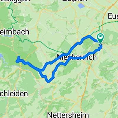
Rundkurs Lessenich-Zingsheim-Lessenich über Römische Straße
A cycling route starting in Mechernich, North Rhine-Westphalia, Germany.
Overview
About this route
Ausgangspunkt Lessenich Waldfriedhof, Parkmöglichkeit, bis Zingsheim fast nur ansteigend, zum Teil steil, z.T über alte Römerstraße, überwiegend befestigte oder asphaltierte Wege, auch mit gutem Touren- oder Trekkingrad zu fahren, aber z.T. recht steile Anstiege, Hinter Pesch römische Tempelanlage im Wald, hier hoch muss z.T. geschoben werden
- -:--
- Duration
- 30.9 km
- Distance
- 439 m
- Ascent
- 436 m
- Descent
- ---
- Avg. speed
- ---
- Avg. speed
Route quality
Waytypes & surfaces along the route
Waytypes
Track
12.8 km
(41 %)
Quiet road
11.9 km
(38 %)
Surfaces
Paved
15.7 km
(51 %)
Unpaved
8.4 km
(27 %)
Asphalt
13.1 km
(42 %)
Unpaved (undefined)
6.4 km
(21 %)
Route highlights
Points of interest along the route
Point of interest after 7.9 km
Kulturdenkmal Römische Straße
Point of interest after 11.5 km
Kulturdenkmal Römische Straße
Point of interest after 18.6 km
römische Tempelanlage
Point of interest after 23 km
Kulturdenkmal Römische STraße
Point of interest after 25.5 km
Bank, schöne Aussicht
Continue with Bikemap
Use, edit, or download this cycling route
You would like to ride Rundkurs Lessenich-Zingsheim-Lessenich über Römische Straße or customize it for your own trip? Here is what you can do with this Bikemap route:
Free features
- Save this route as favorite or in collections
- Copy & plan your own version of this route
- Sync your route with Garmin or Wahoo
Premium features
Free trial for 3 days, or one-time payment. More about Bikemap Premium.
- Navigate this route on iOS & Android
- Export a GPX / KML file of this route
- Create your custom printout (try it for free)
- Download this route for offline navigation
Discover more Premium features.
Get Bikemap PremiumFrom our community
Other popular routes starting in Mechernich
- Schmidtheimer Runde
- Distance
- 80.5 km
- Ascent
- 1,023 m
- Descent
- 1,031 m
- Location
- Mechernich, North Rhine-Westphalia, Germany
- www.Rad-Rebellen.de - Tour 2
- Distance
- 32.1 km
- Ascent
- 408 m
- Descent
- 410 m
- Location
- Mechernich, North Rhine-Westphalia, Germany
- Lessenich - Eschweilerbachtal- Lessenich
- Distance
- 24.5 km
- Ascent
- 244 m
- Descent
- 244 m
- Location
- Mechernich, North Rhine-Westphalia, Germany
- Kommern-Nideggen-Heimbach-Kommern
- Distance
- 53.1 km
- Ascent
- 631 m
- Descent
- 631 m
- Location
- Mechernich, North Rhine-Westphalia, Germany
- Runde über Schleiden
- Distance
- 43.6 km
- Ascent
- 585 m
- Descent
- 574 m
- Location
- Mechernich, North Rhine-Westphalia, Germany
- Querlenker Tour (35,09km, Start Firmenich)
- Distance
- 35.1 km
- Ascent
- 506 m
- Descent
- 508 m
- Location
- Mechernich, North Rhine-Westphalia, Germany
- EifelSchleife Burg Satzvey (Stadt Mechernich) - EifelSchleife Burg Satzvey (Stadt Mechernich)
- Distance
- 7.3 km
- Ascent
- 105 m
- Descent
- 109 m
- Location
- Mechernich, North Rhine-Westphalia, Germany
- Eifelhöhen 2020
- Distance
- 46.9 km
- Ascent
- 637 m
- Descent
- 632 m
- Location
- Mechernich, North Rhine-Westphalia, Germany
Open it in the app