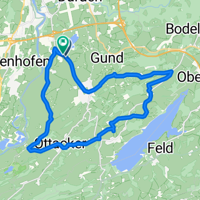
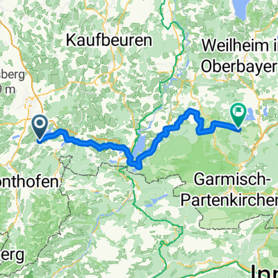
Camping Dopfer/Sulzberger See - Füssen
A cycling route starting in Sulzberg, Bavaria, Germany.
Overview
About this route
- -:--
- Duration
- 43.2 km
- Distance
- 459 m
- Ascent
- 360 m
- Descent
- ---
- Avg. speed
- ---
- Avg. speed
Route quality
Waytypes & surfaces along the route
Waytypes
Quiet road
18 km
(42 %)
Busy road
8.2 km
(19 %)
Surfaces
Paved
37.7 km
(87 %)
Unpaved
0.3 km
(<1 %)
Asphalt
37.1 km
(86 %)
Paved (undefined)
0.6 km
(1 %)
Continue with Bikemap
Use, edit, or download this cycling route
You would like to ride Camping Dopfer/Sulzberger See - Füssen or customize it for your own trip? Here is what you can do with this Bikemap route:
Free features
- Save this route as favorite or in collections
- Copy & plan your own version of this route
- Sync your route with Garmin or Wahoo
Premium features
Free trial for 3 days, or one-time payment. More about Bikemap Premium.
- Navigate this route on iOS & Android
- Export a GPX / KML file of this route
- Create your custom printout (try it for free)
- Download this route for offline navigation
Discover more Premium features.
Get Bikemap PremiumFrom our community
Other popular routes starting in Sulzberg
- Biken am Rottachberg
- Distance
- 44.3 km
- Ascent
- 1,060 m
- Descent
- 1,058 m
- Location
- Sulzberg, Bavaria, Germany
- rund Öschlesee-Fuß
- Distance
- 3.5 km
- Ascent
- 8 m
- Descent
- 9 m
- Location
- Sulzberg, Bavaria, Germany
- Sulzberg-Säge Sulzberg-Ried-Schlechtenberg-Römerhaus-Hasenried-Aleuthe-Säge Sulzberg-Sulzberg
- Distance
- 9.1 km
- Ascent
- 170 m
- Descent
- 167 m
- Location
- Sulzberg, Bavaria, Germany
- Sulzberg-Römerhaus-Hasenried-Aleuthe-Sulzberg
- Distance
- 6.1 km
- Ascent
- 209 m
- Descent
- 208 m
- Location
- Sulzberg, Bavaria, Germany
- Rottachsee
- Distance
- 14.7 km
- Ascent
- 224 m
- Descent
- 227 m
- Location
- Sulzberg, Bavaria, Germany
- Riedis
- Distance
- 4.7 km
- Ascent
- 94 m
- Descent
- 86 m
- Location
- Sulzberg, Bavaria, Germany
- Camping Dopfer/Sulzberger See - Füssen
- Distance
- 43.2 km
- Ascent
- 459 m
- Descent
- 360 m
- Location
- Sulzberg, Bavaria, Germany
- Sulzberger See-Elleghöhe-Königssträßchen-Niedersonthofen-Hellengerst-Martinszell
- Distance
- 87.2 km
- Ascent
- 1,052 m
- Descent
- 1,052 m
- Location
- Sulzberg, Bavaria, Germany
Open it in the app