

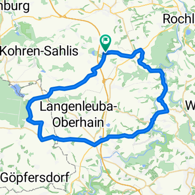
rund um obergäfenhain
A cycling route starting in Narsdorf, Saxony, Germany.
Overview
About this route
beautiful route with little traffic, be careful on the B 175
- -:--
- Duration
- 40.7 km
- Distance
- 279 m
- Ascent
- 303 m
- Descent
- ---
- Avg. speed
- 275 m
- Max. altitude
Route quality
Waytypes & surfaces along the route
Waytypes
Road
15.5 km
(38 %)
Quiet road
7.7 km
(19 %)
Surfaces
Paved
21.6 km
(53 %)
Unpaved
1.6 km
(4 %)
Asphalt
21.6 km
(53 %)
Gravel
1.6 km
(4 %)
Undefined
17.5 km
(43 %)
Continue with Bikemap
Use, edit, or download this cycling route
You would like to ride rund um obergäfenhain or customize it for your own trip? Here is what you can do with this Bikemap route:
Free features
- Save this route as favorite or in collections
- Copy & plan your own version of this route
- Sync your route with Garmin or Wahoo
Premium features
Free trial for 3 days, or one-time payment. More about Bikemap Premium.
- Navigate this route on iOS & Android
- Export a GPX / KML file of this route
- Create your custom printout (try it for free)
- Download this route for offline navigation
Discover more Premium features.
Get Bikemap PremiumFrom our community
Other popular routes starting in Narsdorf
 rund um obergäfenhain
- Distance
- 40.7 km
- Ascent
- 279 m
- Descent
- 303 m
- Location
- Narsdorf, Saxony, Germany
 Tour 09/2009 ESA
- Distance
- 65.4 km
- Ascent
- 480 m
- Descent
- 514 m
- Location
- Narsdorf, Saxony, Germany
 rund um talsperre kriebstein
- Distance
- 74.7 km
- Ascent
- 605 m
- Descent
- 608 m
- Location
- Narsdorf, Saxony, Germany
 Narsdorf - Wechselburg - Rochlitz - Geithain-(Sommerhof) - Narsdorf
- Distance
- 31.2 km
- Ascent
- 255 m
- Descent
- 256 m
- Location
- Narsdorf, Saxony, Germany
 11-01-22 Narsdorf Borna Windischleuba
- Distance
- 68.5 km
- Ascent
- 251 m
- Descent
- 248 m
- Location
- Narsdorf, Saxony, Germany
 muldental und rochlitzerberg
- Distance
- 61.4 km
- Ascent
- 530 m
- Descent
- 526 m
- Location
- Narsdorf, Saxony, Germany
 Narsdorf-Panitzsch
- Distance
- 50.9 km
- Ascent
- 79 m
- Descent
- 225 m
- Location
- Narsdorf, Saxony, Germany
 Ins Chemnitztal
- Distance
- 45.5 km
- Ascent
- 410 m
- Descent
- 408 m
- Location
- Narsdorf, Saxony, Germany
Open it in the app