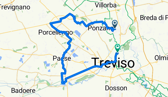
MTB nord ovest e Ostiglia
A cycling route starting in Lancenigo-Villorba, Veneto, Italy.
Overview
About this route
- -:--
- Duration
- 35.9 km
- Distance
- 49 m
- Ascent
- 51 m
- Descent
- ---
- Avg. speed
- ---
- Max. altitude
Route quality
Waytypes & surfaces along the route
Waytypes
Quiet road
10.5 km
(29 %)
Track
9 km
(25 %)
Surfaces
Paved
14.5 km
(40 %)
Unpaved
4.2 km
(12 %)
Asphalt
14.4 km
(40 %)
Loose gravel
1.4 km
(4 %)
Continue with Bikemap
Use, edit, or download this cycling route
You would like to ride MTB nord ovest e Ostiglia or customize it for your own trip? Here is what you can do with this Bikemap route:
Free features
- Save this route as favorite or in collections
- Copy & plan your own version of this route
- Sync your route with Garmin or Wahoo
Premium features
Free trial for 3 days, or one-time payment. More about Bikemap Premium.
- Navigate this route on iOS & Android
- Export a GPX / KML file of this route
- Create your custom printout (try it for free)
- Download this route for offline navigation
Discover more Premium features.
Get Bikemap PremiumFrom our community
Other popular routes starting in Lancenigo-Villorba
- MTB nord ovest e Ostiglia
- Distance
- 35.9 km
- Ascent
- 49 m
- Descent
- 51 m
- Location
- Lancenigo-Villorba, Veneto, Italy
- Ponzano Caposile via restera
- Distance
- 92.3 km
- Ascent
- 68 m
- Descent
- 85 m
- Location
- Lancenigo-Villorba, Veneto, Italy
- Montello gravel a Carnevale
- Distance
- 55.4 km
- Ascent
- 266 m
- Descent
- 265 m
- Location
- Lancenigo-Villorba, Veneto, Italy
- Pedalata lungo il Pegorile e la Botteniga (San Pelajo-Treviso)
- Distance
- 10.4 km
- Ascent
- 13 m
- Descent
- 13 m
- Location
- Lancenigo-Villorba, Veneto, Italy
- VILLORBA A PEDALI
- Distance
- 62.2 km
- Ascent
- 70 m
- Descent
- 69 m
- Location
- Lancenigo-Villorba, Veneto, Italy
- Via Vascon 33–37, Villorba to Località Passo San Boldo 4, San Boldo
- Distance
- 52.9 km
- Ascent
- 1,099 m
- Descent
- 1,125 m
- Location
- Lancenigo-Villorba, Veneto, Italy
- Ride through Villorba (Treviso)
- Distance
- 20.8 km
- Ascent
- 29 m
- Descent
- 30 m
- Location
- Lancenigo-Villorba, Veneto, Italy
- monfenera
- Distance
- 96.6 km
- Ascent
- 934 m
- Descent
- 935 m
- Location
- Lancenigo-Villorba, Veneto, Italy
Open it in the app