

HIdden Hertfordshire
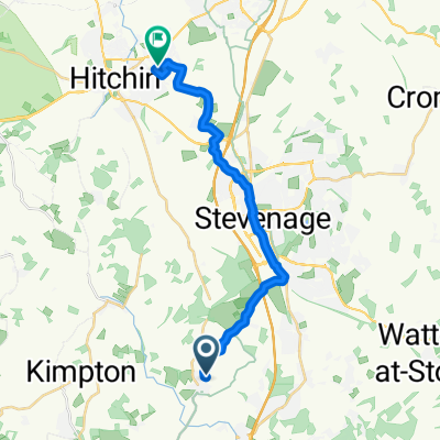
A cycling route starting in Codicote, England, United Kingdom.
Overview
About this route
A quiet corner of the home counties that's full of unexpected delights, from an Iron Age hill fort to a haunted chapel
- -:--
- Duration
- 59.1 km
- Distance
- 333 m
- Ascent
- 327 m
- Descent
- ---
- Avg. speed
- ---
- Max. altitude
Route quality
Waytypes & surfaces along the route
Waytypes
Road
30.7 km
(52 %)
Quiet road
18.3 km
(31 %)
Surfaces
Paved
45.5 km
(77 %)
Unpaved
1.2 km
(2 %)
Asphalt
45.5 km
(77 %)
Gravel
1.2 km
(2 %)
Undefined
12.4 km
(21 %)
Continue with Bikemap
Use, edit, or download this cycling route
You would like to ride HIdden Hertfordshire or customize it for your own trip? Here is what you can do with this Bikemap route:
Free features
- Save this route as favorite or in collections
- Copy & plan your own version of this route
- Sync your route with Garmin or Wahoo
Premium features
Free trial for 3 days, or one-time payment. More about Bikemap Premium.
- Navigate this route on iOS & Android
- Export a GPX / KML file of this route
- Create your custom printout (try it for free)
- Download this route for offline navigation
Discover more Premium features.
Get Bikemap PremiumFrom our community
Other popular routes starting in Codicote
 HIdden Hertfordshire
- Distance
- 59.1 km
- Ascent
- 333 m
- Descent
- 327 m
- Location
- Codicote, England, United Kingdom
 Codicote to Salcombe 2020
- Distance
- 451.4 km
- Ascent
- 1,301 m
- Descent
- 1,334 m
- Location
- Codicote, England, United Kingdom
 The Bury, Hitchin to 131 Coleridge Close, Hitchin
- Distance
- 17 km
- Ascent
- 88 m
- Descent
- 129 m
- Location
- Codicote, England, United Kingdom
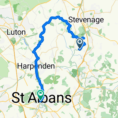 Ridge Farm, Rabley Heath Road, Welwyn to Village Arcade, 7 High Street, St Albans
- Distance
- 41.4 km
- Ascent
- 401 m
- Descent
- 398 m
- Location
- Codicote, England, United Kingdom
 Recovered Route
- Distance
- 17.1 km
- Ascent
- 162 m
- Descent
- 191 m
- Location
- Codicote, England, United Kingdom
 1–2 Old Brewery Pl, Kimpton, Hitchin to 1 Carmarthen Road, Llandeilo
- Distance
- 329.8 km
- Ascent
- 3,371 m
- Descent
- 3,384 m
- Location
- Codicote, England, United Kingdom
 First Ride to get Back in the Swing
- Distance
- 15.3 km
- Ascent
- 159 m
- Descent
- 158 m
- Location
- Codicote, England, United Kingdom
 VCC Evening 10 course
- Distance
- 16.1 km
- Ascent
- 95 m
- Descent
- 89 m
- Location
- Codicote, England, United Kingdom
Open it in the app