Gippingen - Buch - Niederwihl
A cycling route starting in Stein, Canton of Aargau, Switzerland.
Overview
About this route
- -:--
- Duration
- 80.1 km
- Distance
- 779 m
- Ascent
- 780 m
- Descent
- ---
- Avg. speed
- ---
- Avg. speed
Route quality
Waytypes & surfaces along the route
Waytypes
Busy road
31.9 km
(40 %)
Road
19 km
(24 %)
Surfaces
Paved
66.4 km
(83 %)
Unpaved
0.4 km
(<1 %)
Asphalt
63.5 km
(79 %)
Paved (undefined)
2.7 km
(3 %)
Continue with Bikemap
Use, edit, or download this cycling route
You would like to ride Gippingen - Buch - Niederwihl or customize it for your own trip? Here is what you can do with this Bikemap route:
Free features
- Save this route as favorite or in collections
- Copy & plan your own version of this route
- Sync your route with Garmin or Wahoo
Premium features
Free trial for 3 days, or one-time payment. More about Bikemap Premium.
- Navigate this route on iOS & Android
- Export a GPX / KML file of this route
- Create your custom printout (try it for free)
- Download this route for offline navigation
Discover more Premium features.
Get Bikemap PremiumFrom our community
Other popular routes starting in Stein
- Murgtaltour
- Distance
- 26.2 km
- Ascent
- 654 m
- Descent
- 599 m
- Location
- Stein, Canton of Aargau, Switzerland
- 2TT/2016 Bad Säckingen - Bern
- Distance
- 114 km
- Ascent
- 860 m
- Descent
- 605 m
- Location
- Stein, Canton of Aargau, Switzerland
- Gippingen - Mandach - Gansingen - Sulz
- Distance
- 62.4 km
- Ascent
- 625 m
- Descent
- 625 m
- Location
- Stein, Canton of Aargau, Switzerland
- Erste Tour von Wehr nach Laufenburg
- Distance
- 32.9 km
- Ascent
- 503 m
- Descent
- 479 m
- Location
- Stein, Canton of Aargau, Switzerland
- Fisibach-Schneisingen-Gansingen
- Distance
- 106.8 km
- Ascent
- 687 m
- Descent
- 687 m
- Location
- Stein, Canton of Aargau, Switzerland
- 19,04.19 venerdi pascqua 👍
- Distance
- 31.4 km
- Ascent
- 119 m
- Descent
- 119 m
- Location
- Stein, Canton of Aargau, Switzerland
- Gippingen - Albruck - Hottingen - Hornberg - Bergalingen
- Distance
- 99.7 km
- Ascent
- 1,056 m
- Descent
- 1,056 m
- Location
- Stein, Canton of Aargau, Switzerland
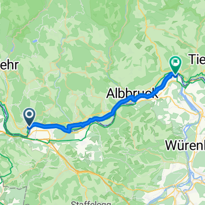
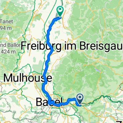
- Vorschlag Route sehr schön, wenig Verkehr
- Distance
- 80.7 km
- Ascent
- 2,565 m
- Descent
- 2,606 m
- Location
- Stein, Canton of Aargau, Switzerland
Open it in the app