
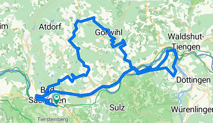
Säckingen - Gippingen - Buch - Strittmatt - Oberhof - Harpolingen - Säckingen
A cycling route starting in Stein, Canton of Aargau, Switzerland.
Overview
About this route
- -:--
- Duration
- 98.8 km
- Distance
- 977 m
- Ascent
- 976 m
- Descent
- ---
- Avg. speed
- ---
- Max. altitude

Route quality
Waytypes & surfaces along the route
Waytypes
Quiet road
18.8 km
(19 %)
Road
17.8 km
(18 %)
Surfaces
Paved
78 km
(79 %)
Unpaved
2 km
(2 %)
Asphalt
74.1 km
(75 %)
Paved (undefined)
4 km
(4 %)
Continue with Bikemap
Use, edit, or download this cycling route
You would like to ride Säckingen - Gippingen - Buch - Strittmatt - Oberhof - Harpolingen - Säckingen or customize it for your own trip? Here is what you can do with this Bikemap route:
Free features
- Save this route as favorite or in collections
- Copy & plan your own version of this route
- Split it into stages to create a multi-day tour
- Sync your route with Garmin or Wahoo
Premium features
Free trial for 3 days, or one-time payment. More about Bikemap Premium.
- Navigate this route on iOS & Android
- Export a GPX / KML file of this route
- Create your custom printout (try it for free)
- Download this route for offline navigation
Discover more Premium features.
Get Bikemap PremiumFrom our community
Other popular routes starting in Stein
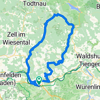
 Gippingen - Albruck - Hottingen - Hornberg - Bergalingen
- Distance
- 99.7 km
- Ascent
- 1,056 m
- Descent
- 1,056 m
- Location
- Stein, Canton of Aargau, Switzerland
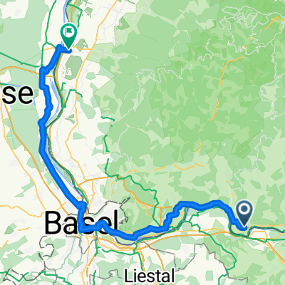
 Bad Säckingen Rheinroute Waldshut
- Distance
- 59.7 km
- Ascent
- 469 m
- Descent
- 472 m
- Location
- Stein, Canton of Aargau, Switzerland
 Bad Säckingen - Wehr Runde
- Distance
- 28.7 km
- Ascent
- 285 m
- Descent
- 284 m
- Location
- Stein, Canton of Aargau, Switzerland
 Vorschlag Route sehr schön, wenig Verkehr
- Distance
- 80.7 km
- Ascent
- 2,565 m
- Descent
- 2,606 m
- Location
- Stein, Canton of Aargau, Switzerland
 Gippingen - Buch - Niederwihl
- Distance
- 80.1 km
- Ascent
- 779 m
- Descent
- 780 m
- Location
- Stein, Canton of Aargau, Switzerland
 Erste Tour von Wehr nach Laufenburg
- Distance
- 32.9 km
- Ascent
- 503 m
- Descent
- 479 m
- Location
- Stein, Canton of Aargau, Switzerland
 Wehr - Todtmoos - Bernau - Tiefenstein - Oberwihl - Murg
- Distance
- 109.1 km
- Ascent
- 1,179 m
- Descent
- 1,179 m
- Location
- Stein, Canton of Aargau, Switzerland
 Tag 12 : Weihermatten, Bad Säckingen nach Kreuzstraße, Neuenburg am Rhein
- Distance
- 76.5 km
- Ascent
- 263 m
- Descent
- 344 m
- Location
- Stein, Canton of Aargau, Switzerland
Open it in the app