

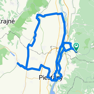
Slowakei Tatra
A cycling route starting in Piešťany, Trnava Region, Slovakia.
Overview
About this route
Ridden: summer 2019
- -:--
- Duration
- 585.3 km
- Distance
- 2,732 m
- Ascent
- 2,703 m
- Descent
- ---
- Avg. speed
- 1,241 m
- Max. altitude

Route quality
Waytypes & surfaces along the route
Waytypes
Road
111.2 km
(19 %)
Quiet road
87.8 km
(15 %)
Surfaces
Paved
362.9 km
(62 %)
Unpaved
17.6 km
(3 %)
Asphalt
345.3 km
(59 %)
Paved (undefined)
17.6 km
(3 %)
Route highlights
Points of interest along the route
Point of interest after 0 km
Camping Pulmann
Point of interest after 106 km
Camping Maninska Tiesnava "Biker"
Point of interest after 169.8 km
Camping Bela Nizne "schönster Camping" Darius
Point of interest after 237.7 km
Seecamping Old Mountain
Point of interest after 285 km
Camping Pod Krokwią Bungalow
Point of interest after 367 km
Camping Štrba
Point of interest after 446.9 km
Hippie Camping Chata Mirka
Point of interest after 556.7 km
Party Camping ATC NITRIANSKE RUDNO
Continue with Bikemap
Use, edit, or download this cycling route
You would like to ride Slowakei Tatra or customize it for your own trip? Here is what you can do with this Bikemap route:
Free features
- Save this route as favorite or in collections
- Copy & plan your own version of this route
- Split it into stages to create a multi-day tour
- Sync your route with Garmin or Wahoo
Premium features
Free trial for 3 days, or one-time payment. More about Bikemap Premium.
- Navigate this route on iOS & Android
- Export a GPX / KML file of this route
- Create your custom printout (try it for free)
- Download this route for offline navigation
Discover more Premium features.
Get Bikemap PremiumFrom our community
Other popular routes starting in Piešťany
 Kičimoprofesioneljazdeníčko
- Distance
- 13.3 km
- Ascent
- 23 m
- Descent
- 20 m
- Location
- Piešťany, Trnava Region, Slovakia
 F1_L1 PN - JasterHC
- Distance
- 18.8 km
- Ascent
- 68 m
- Descent
- 58 m
- Location
- Piešťany, Trnava Region, Slovakia
 Modrová - Vrbové - Modrová
- Distance
- 79 km
- Ascent
- 223 m
- Descent
- 222 m
- Location
- Piešťany, Trnava Region, Slovakia
 Piešťany - Prievaly
- Distance
- 69.2 km
- Ascent
- 1,535 m
- Descent
- 1,449 m
- Location
- Piešťany, Trnava Region, Slovakia
 Recording from 9. 4. 2017, 13:06
- Distance
- 11.3 km
- Ascent
- 364 m
- Descent
- 317 m
- Location
- Piešťany, Trnava Region, Slovakia
 Recording from 22. apríla 9:17
- Distance
- 64.8 km
- Ascent
- 385 m
- Descent
- 383 m
- Location
- Piešťany, Trnava Region, Slovakia
 Pod Párovcami do Žilinská cesta
- Distance
- 41.7 km
- Ascent
- 203 m
- Descent
- 202 m
- Location
- Piešťany, Trnava Region, Slovakia
 PN-TN
PN-TN- Distance
- 39.8 km
- Ascent
- 157 m
- Descent
- 144 m
- Location
- Piešťany, Trnava Region, Slovakia
Open it in the app