

Route im Schneckentempo in Bayreuth
A cycling route starting in Bayreuth, Bavaria, Germany.
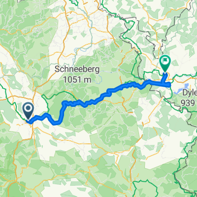
Overview
About this route
- 1 h 58 min
- Duration
- 23.1 km
- Distance
- 585 m
- Ascent
- 547 m
- Descent
- 11.7 km/h
- Avg. speed
- ---
- Max. altitude

Route photos


Continue with Bikemap
Use, edit, or download this cycling route
You would like to ride Route im Schneckentempo in Bayreuth or customize it for your own trip? Here is what you can do with this Bikemap route:
Free features
- Save this route as favorite or in collections
- Copy & plan your own version of this route
- Sync your route with Garmin or Wahoo
Premium features
Free trial for 3 days, or one-time payment. More about Bikemap Premium.
- Navigate this route on iOS & Android
- Export a GPX / KML file of this route
- Create your custom printout (try it for free)
- Download this route for offline navigation
Discover more Premium features.
Get Bikemap PremiumFrom our community
Other popular routes starting in Bayreuth
 Bayreuth, Bindlach, Bayreuth
- Distance
- 18.9 km
- Ascent
- 200 m
- Descent
- 197 m
- Location
- Bayreuth, Bavaria, Germany
 RoterMainQuelle (kurz)
- Distance
- 30.9 km
- Ascent
- 345 m
- Descent
- 346 m
- Location
- Bayreuth, Bavaria, Germany
 Main-Radweg – aus Trekkingbike 5/2012 - editiert 2
- Distance
- 519.1 km
- Ascent
- 167 m
- Descent
- 411 m
- Location
- Bayreuth, Bavaria, Germany
 BT-Marienweiher-BT
- Distance
- 89.1 km
- Ascent
- 703 m
- Descent
- 703 m
- Location
- Bayreuth, Bavaria, Germany
 11.07.23 Bayreuth-Lichtenfels (6. Etappe)
- Distance
- 76.8 km
- Ascent
- 248 m
- Descent
- 334 m
- Location
- Bayreuth, Bavaria, Germany
 Von Bayreuth bis Eger
- Distance
- 93.2 km
- Ascent
- 1,167 m
- Descent
- 1,069 m
- Location
- Bayreuth, Bavaria, Germany
 Oschenberg inkl. Arschkerbe
- Distance
- 24.8 km
- Ascent
- 306 m
- Descent
- 307 m
- Location
- Bayreuth, Bavaria, Germany
 Unbenannte Route
- Distance
- 190.2 km
- Ascent
- 919 m
- Descent
- 1,061 m
- Location
- Bayreuth, Bavaria, Germany
Open it in the app