

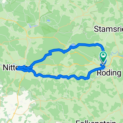
Roding - Miltach
A cycling route starting in Roding, Bavaria, Germany.
Overview
About this route
- -:--
- Duration
- 29.8 km
- Distance
- 120 m
- Ascent
- 135 m
- Descent
- ---
- Avg. speed
- ---
- Max. altitude
Route quality
Waytypes & surfaces along the route
Waytypes
Quiet road
14.1 km
(47 %)
Path
7.6 km
(26 %)
Surfaces
Paved
20.3 km
(68 %)
Unpaved
0.3 km
(1 %)
Asphalt
17.1 km
(57 %)
Paved (undefined)
3.1 km
(10 %)
Continue with Bikemap
Use, edit, or download this cycling route
You would like to ride Roding - Miltach or customize it for your own trip? Here is what you can do with this Bikemap route:
Free features
- Save this route as favorite or in collections
- Copy & plan your own version of this route
- Sync your route with Garmin or Wahoo
Premium features
Free trial for 3 days, or one-time payment. More about Bikemap Premium.
- Navigate this route on iOS & Android
- Export a GPX / KML file of this route
- Create your custom printout (try it for free)
- Download this route for offline navigation
Discover more Premium features.
Get Bikemap PremiumFrom our community
Other popular routes starting in Roding
 Nittenau zu zweit
- Distance
- 47.3 km
- Ascent
- 621 m
- Descent
- 621 m
- Location
- Roding, Bavaria, Germany
 Kalkbrennerweg 2, Roding nach Dr.-Götz-Straße 1, Falkenstein
- Distance
- 15 km
- Ascent
- 507 m
- Descent
- 307 m
- Location
- Roding, Bavaria, Germany
 Regentour
- Distance
- 44.2 km
- Ascent
- 416 m
- Descent
- 415 m
- Location
- Roding, Bavaria, Germany
 Roding_Strahlfeld_Neubäu_Zenzing_Roding
- Distance
- 32.3 km
- Ascent
- 408 m
- Descent
- 409 m
- Location
- Roding, Bavaria, Germany
 Roding - Furth im Walde
- Distance
- 36.7 km
- Ascent
- 123 m
- Descent
- 86 m
- Location
- Roding, Bavaria, Germany
 Berg - Wiesing Beucherling Wald Falkenstein
- Distance
- 59.5 km
- Ascent
- 683 m
- Descent
- 683 m
- Location
- Roding, Bavaria, Germany
 Roding - Miltach
- Distance
- 29.8 km
- Ascent
- 120 m
- Descent
- 135 m
- Location
- Roding, Bavaria, Germany
 Höllgasse, Roding nach Altenmarkter Straße, Cham
- Distance
- 16.2 km
- Ascent
- 81 m
- Descent
- 75 m
- Location
- Roding, Bavaria, Germany
Open it in the app