

Ohanes dos veredas
A cycling route starting in Ohanes, Andalusia, Spain.
Overview
About this route
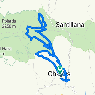
Route that climbs from Ohanes to descend via the Sulayr trail. Then it climbs again to descend towards Ohanes by another path.
- -:--
- Duration
- 38.6 km
- Distance
- 1,184 m
- Ascent
- 1,179 m
- Descent
- ---
- Avg. speed
- ---
- Max. altitude

Route quality
Waytypes & surfaces along the route
Waytypes
Track
34.3 km
(89 %)
Path
3.1 km
(8 %)
Road
1.2 km
(3 %)
Surfaces
Unpaved
4.2 km
(11 %)
Gravel
4.2 km
(11 %)
Undefined
34.3 km
(89 %)
Continue with Bikemap
Use, edit, or download this cycling route
You would like to ride Ohanes dos veredas or customize it for your own trip? Here is what you can do with this Bikemap route:
Free features
- Save this route as favorite or in collections
- Copy & plan your own version of this route
- Sync your route with Garmin or Wahoo
Premium features
Free trial for 3 days, or one-time payment. More about Bikemap Premium.
- Navigate this route on iOS & Android
- Export a GPX / KML file of this route
- Create your custom printout (try it for free)
- Download this route for offline navigation
Discover more Premium features.
Get Bikemap PremiumFrom our community
Other popular routes starting in Ohanes
 ohanes - Buitre - Puerto la Ragua - Ohanes
- Distance
- 97.5 km
- Ascent
- 1,873 m
- Descent
- 1,858 m
- Location
- Ohanes, Andalusia, Spain
 Ohanes - Buitre( doble opcion de descenso)
- Distance
- 74.3 km
- Ascent
- 1,994 m
- Descent
- 2,002 m
- Location
- Ohanes, Andalusia, Spain
 Subida al Galayo desde Aljibe de Don Juan (Cortijo Simona)
- Distance
- 5.3 km
- Ascent
- ---
- Descent
- ---
- Location
- Ohanes, Andalusia, Spain
 Ohanes-Polarda-Ohanes (por Sulayr + sendero)
- Distance
- 42.7 km
- Ascent
- 1,330 m
- Descent
- 1,330 m
- Location
- Ohanes, Andalusia, Spain
 Ohanes-sulayr
- Distance
- 44.9 km
- Ascent
- 1,335 m
- Descent
- 1,335 m
- Location
- Ohanes, Andalusia, Spain
 Ruta Transnevada E4V: Collado del Espino - Puerto de la Ragua
- Distance
- 35.2 km
- Ascent
- 676 m
- Descent
- 508 m
- Location
- Ohanes, Andalusia, Spain
 Subida al Pico Galayo desde Tices
- Distance
- 6.8 km
- Ascent
- 629 m
- Descent
- 40 m
- Location
- Ohanes, Andalusia, Spain
 Ohanes- Cantarranas-Collado del Espino- Fuente del Cerrajero-Sulayr-Cerro de la Coronela-Cantarranas-Sendero de Ohanes
- Distance
- 37.6 km
- Ascent
- 1,374 m
- Descent
- 1,358 m
- Location
- Ohanes, Andalusia, Spain
Open it in the app