

testw
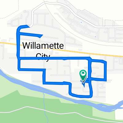
A cycling route starting in Oakridge, Oregon, United States.
Overview
About this route
rwar
- -:--
- Duration
- 9.1 km
- Distance
- 201 m
- Ascent
- 194 m
- Descent
- ---
- Avg. speed
- ---
- Max. altitude
Route quality
Waytypes & surfaces along the route
Waytypes
Quiet road
5.6 km
(61 %)
Road
3.6 km
(39 %)
Surfaces
Paved
0.2 km
(2 %)
Paved (undefined)
0.2 km
(2 %)
Undefined
8.9 km
(98 %)
Continue with Bikemap
Use, edit, or download this cycling route
You would like to ride testw or customize it for your own trip? Here is what you can do with this Bikemap route:
Free features
- Save this route as favorite or in collections
- Copy & plan your own version of this route
- Sync your route with Garmin or Wahoo
Premium features
Free trial for 3 days, or one-time payment. More about Bikemap Premium.
- Navigate this route on iOS & Android
- Export a GPX / KML file of this route
- Create your custom printout (try it for free)
- Download this route for offline navigation
Discover more Premium features.
Get Bikemap PremiumFrom our community
Other popular routes starting in Oakridge
 July2021DualSportRide
- Distance
- 348.9 km
- Ascent
- 4,980 m
- Descent
- 4,957 m
- Location
- Oakridge, Oregon, United States
 Day 4 (7/28): Packard Creek Campground - Indigo Springs Campground
- Distance
- 38 km
- Ascent
- 675 m
- Descent
- 329 m
- Location
- Oakridge, Oregon, United States
 Larison Rock Loop, Oakridge
- Distance
- 17.6 km
- Ascent
- 707 m
- Descent
- 707 m
- Location
- Oakridge, Oregon, United States
 Rainbow Road 76332, Oakridge to Rainbow Road 76332, Oakridge
- Distance
- 8.8 km
- Ascent
- 30 m
- Descent
- 10 m
- Location
- Oakridge, Oregon, United States
 Oakridge to Eugene
- Distance
- 72.6 km
- Ascent
- 311 m
- Descent
- 539 m
- Location
- Oakridge, Oregon, United States
 Rainbow Road 76332, Oakridge to Rainbow Road 76332, Oakridge
- Distance
- 6.5 km
- Ascent
- 30 m
- Descent
- 13 m
- Location
- Oakridge, Oregon, United States
 Rainbow Road 76332, Oakridge to Rainbow Road 76332, Oakridge
- Distance
- 9.1 km
- Ascent
- 26 m
- Descent
- 10 m
- Location
- Oakridge, Oregon, United States
 Rainbow Road 76332, Oakridge to Rainbow Road 76332, Oakridge
- Distance
- 8.9 km
- Ascent
- 13 m
- Descent
- 13 m
- Location
- Oakridge, Oregon, United States
Open it in the app