

Gražutės nacionalinis parkas
A cycling route starting in Visaginas, Utena County, Lithuania.
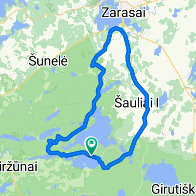
Overview
About this route
- -:--
- Duration
- 75.7 km
- Distance
- 0 m
- Ascent
- 162 m
- Descent
- ---
- Avg. speed
- ---
- Max. altitude

Continue with Bikemap
Use, edit, or download this cycling route
You would like to ride Gražutės nacionalinis parkas or customize it for your own trip? Here is what you can do with this Bikemap route:
Free features
- Save this route as favorite or in collections
- Copy & plan your own version of this route
- Sync your route with Garmin or Wahoo
Premium features
Free trial for 3 days, or one-time payment. More about Bikemap Premium.
- Navigate this route on iOS & Android
- Export a GPX / KML file of this route
- Create your custom printout (try it for free)
- Download this route for offline navigation
Discover more Premium features.
Get Bikemap PremiumFrom our community
Other popular routes starting in Visaginas
 Slow ride in Lietuva
- Distance
- 0.2 km
- Ascent
- 3 m
- Descent
- 3 m
- Location
- Visaginas, Utena County, Lithuania
 Gražutės mažasis
- Distance
- 34.7 km
- Ascent
- 161 m
- Descent
- 163 m
- Location
- Visaginas, Utena County, Lithuania
 Smalvos MTB root
- Distance
- 19 km
- Ascent
- 102 m
- Descent
- 104 m
- Location
- Visaginas, Utena County, Lithuania
 100 km - Most Epic Gravel Ride Ever 2020
- Distance
- 98.4 km
- Ascent
- 673 m
- Descent
- 673 m
- Location
- Visaginas, Utena County, Lithuania
 Baltas trail
- Distance
- 6.6 km
- Ascent
- 59 m
- Descent
- 45 m
- Location
- Visaginas, Utena County, Lithuania
 Smalvo–Smalvykščio Track
- Distance
- 18.2 km
- Ascent
- 163 m
- Descent
- 160 m
- Location
- Visaginas, Utena County, Lithuania
 De Kauno gatvė 67, Zarasai à Tilto gatvė 14, Vilnius
- Distance
- 230 km
- Ascent
- 1,432 m
- Descent
- 1,473 m
- Location
- Visaginas, Utena County, Lithuania
 Velykų MTB
- Distance
- 6.1 km
- Ascent
- 274 m
- Descent
- 282 m
- Location
- Visaginas, Utena County, Lithuania
Open it in the app