
Tour in AUVERGNE (F)
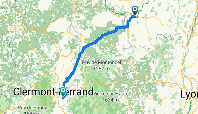
6a tappa→Paray Le Monial---Cournon D'Auvergne
A cycling route starting in Paray-le-Monial, Bourgogne-Franche-Comté, France.
Overview
About this route
FINISH: Rue de Dallet 11 = at my cousins' place!
- -:--
- Duration
- 138.2 km
- Distance
- 625 m
- Ascent
- 519 m
- Descent
- ---
- Avg. speed
- ---
- Max. altitude

Part of
Tour in AUVERGNE (F)
6 stages
Route quality
Waytypes & surfaces along the route
Waytypes
Road
51.1 km
(37 %)
Quiet road
42.9 km
(31 %)
Surfaces
Paved
63.6 km
(46 %)
Unpaved
16.6 km
(12 %)
Asphalt
60.8 km
(44 %)
Gravel
13.8 km
(10 %)
Continue with Bikemap
Use, edit, or download this cycling route
You would like to ride 6a tappa→Paray Le Monial---Cournon D'Auvergne or customize it for your own trip? Here is what you can do with this Bikemap route:
Free features
- Save this route as favorite or in collections
- Copy & plan your own version of this route
- Split it into stages to create a multi-day tour
- Sync your route with Garmin or Wahoo
Premium features
Free trial for 3 days, or one-time payment. More about Bikemap Premium.
- Navigate this route on iOS & Android
- Export a GPX / KML file of this route
- Create your custom printout (try it for free)
- Download this route for offline navigation
Discover more Premium features.
Get Bikemap PremiumFrom our community
Other popular routes starting in Paray-le-Monial
 Etape 6: bourgogne bis
- Distance
- 47.8 km
- Ascent
- 339 m
- Descent
- 292 m
- Location
- Paray-le-Monial, Bourgogne-Franche-Comté, France
 04 Loire Paray a Nevers 150 km
- Distance
- 151 km
- Ascent
- 236 m
- Descent
- 314 m
- Location
- Paray-le-Monial, Bourgogne-Franche-Comté, France
 6a tappa→Paray Le Monial---Cournon D'Auvergne
- Distance
- 138.2 km
- Ascent
- 625 m
- Descent
- 519 m
- Location
- Paray-le-Monial, Bourgogne-Franche-Comté, France
 Tour de Bourgogne 2
- Distance
- 663 km
- Ascent
- 2,930 m
- Descent
- 2,929 m
- Location
- Paray-le-Monial, Bourgogne-Franche-Comté, France
 massif east 1
- Distance
- 473.1 km
- Ascent
- 2,609 m
- Descent
- 2,698 m
- Location
- Paray-le-Monial, Bourgogne-Franche-Comté, France
 Etape 6 Paray le Monial - Cercy-La-Tour
- Distance
- 98.3 km
- Ascent
- 172 m
- Descent
- 199 m
- Location
- Paray-le-Monial, Bourgogne-Franche-Comté, France
 L3+4 nord: Paray-le-Monial - Macon; 170,1km 250hm
- Distance
- 171.2 km
- Ascent
- 451 m
- Descent
- 507 m
- Location
- Paray-le-Monial, Bourgogne-Franche-Comté, France
 L3: Paray-le-Monial - Joncy; 78,6km 360hm
- Distance
- 78.6 km
- Ascent
- 461 m
- Descent
- 473 m
- Location
- Paray-le-Monial, Bourgogne-Franche-Comté, France
Open it in the app