

MAX to Banks-Vernonia trail
A cycling route starting in Hillsboro, Oregon, United States.
Overview
About this route
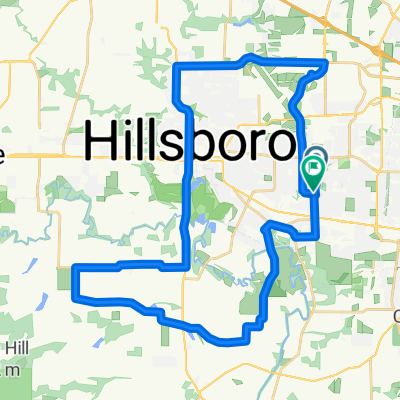
This is a (non-direct) route from the end of the MAX line in Hillsboro to Vernonia. We did the ride over the course of 3 days, with stops to drink wine and swim in the rivers, with camping at Stub Stewar state park both nights.
The return trip isn't shown here. There a few ways to do it, but we choose to take Hwy 47 and visit the Sake Brewery in Forest grove before returning to Portland on the MAX.
The route does have some dirt roads, so a rugged road bike is recommended. The first 2 climbs can be easily avoided, but they provide some good scenery and of course, wine to drink.
- -:--
- Duration
- 68.4 km
- Distance
- 629 m
- Ascent
- 503 m
- Descent
- ---
- Avg. speed
- ---
- Max. altitude
Route quality
Waytypes & surfaces along the route
Waytypes
Quiet road
23.3 km
(34 %)
Cycleway
21.5 km
(31 %)
Surfaces
Paved
47.3 km
(69 %)
Unpaved
9 km
(13 %)
Asphalt
43.7 km
(64 %)
Loose gravel
7.3 km
(11 %)
Route highlights
Points of interest along the route
Point of interest after 10.5 km
Sake One Distillery
Point of interest after 17.2 km
David Hill Winery
Point of interest after 38.8 km
Start of the Banks-Vernonia
Point of interest after 53.7 km
Stub Stewart State Park
Continue with Bikemap
Use, edit, or download this cycling route
You would like to ride MAX to Banks-Vernonia trail or customize it for your own trip? Here is what you can do with this Bikemap route:
Free features
- Save this route as favorite or in collections
- Copy & plan your own version of this route
- Sync your route with Garmin or Wahoo
Premium features
Free trial for 3 days, or one-time payment. More about Bikemap Premium.
- Navigate this route on iOS & Android
- Export a GPX / KML file of this route
- Create your custom printout (try it for free)
- Download this route for offline navigation
Discover more Premium features.
Get Bikemap PremiumFrom our community
Other popular routes starting in Hillsboro
 Thursday 25
- Distance
- 40.2 km
- Ascent
- 90 m
- Descent
- 90 m
- Location
- Hillsboro, Oregon, United States
 25 mile
- Distance
- 39.2 km
- Ascent
- 100 m
- Descent
- 99 m
- Location
- Hillsboro, Oregon, United States
 To east end of rock creek trail
- Distance
- 36.3 km
- Ascent
- 139 m
- Descent
- 136 m
- Location
- Hillsboro, Oregon, United States
 843 NE Birchaire Ln, Hillsboro to 843 NE Birchaire Ln, Hillsboro
- Distance
- 5 km
- Ascent
- 33 m
- Descent
- 39 m
- Location
- Hillsboro, Oregon, United States
 Hillsboro Loop
- Distance
- 35.4 km
- Ascent
- 98 m
- Descent
- 93 m
- Location
- Hillsboro, Oregon, United States
 Steady ride in Hillsboro
- Distance
- 15 km
- Ascent
- 78 m
- Descent
- 76 m
- Location
- Hillsboro, Oregon, United States
 Recovered Route
- Distance
- 3.6 km
- Ascent
- 3 m
- Descent
- 3 m
- Location
- Hillsboro, Oregon, United States
 Relaxed route in Hillsboro
- Distance
- 41.3 km
- Ascent
- 385 m
- Descent
- 384 m
- Location
- Hillsboro, Oregon, United States
Open it in the app