

Verl-Bad Lippspringe-Verl
A cycling route starting in Verl, North Rhine-Westphalia, Germany.
Overview
About this route
Start and endpoint: Marktstraße Verl,
Start N 51.881410° E 8.509471°
Destination N 51.881 332° E 8.509354°
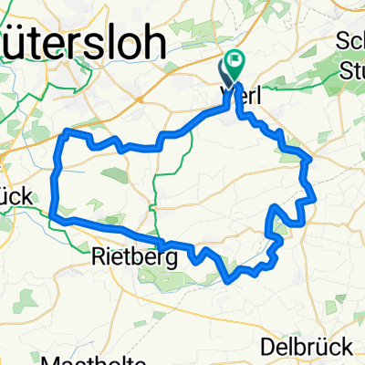
From Verl via Riege to Hövelhof and further to Staumühle. From here across the military training area to Bad Lippspringe. Please pay attention to the closure times. (www.augustdorf.de/rathaus/sennesperrzeiten). Usually open on weekends and public holidays. From Bad Lippspringe via Marienloh to Schloss Neuhaus and further along Lippesee to Sande. There is an ice cream parlor behind the roundabout at Ostenländer Str. Continue through Mühlensenne to Ostenland, Espeln, and Kaunitz back to Verl.
- -:--
- Duration
- 68.8 km
- Distance
- 224 m
- Ascent
- 225 m
- Descent
- ---
- Avg. speed
- ---
- Max. altitude
Route quality
Waytypes & surfaces along the route
Waytypes
Quiet road
46.1 km
(67 %)
Path
13.8 km
(20 %)
Surfaces
Paved
52.3 km
(76 %)
Unpaved
4.8 km
(7 %)
Asphalt
51.6 km
(75 %)
Gravel
4.1 km
(6 %)
Continue with Bikemap
Use, edit, or download this cycling route
You would like to ride Verl-Bad Lippspringe-Verl or customize it for your own trip? Here is what you can do with this Bikemap route:
Free features
- Save this route as favorite or in collections
- Copy & plan your own version of this route
- Sync your route with Garmin or Wahoo
Premium features
Free trial for 3 days, or one-time payment. More about Bikemap Premium.
- Navigate this route on iOS & Android
- Export a GPX / KML file of this route
- Create your custom printout (try it for free)
- Download this route for offline navigation
Discover more Premium features.
Get Bikemap PremiumFrom our community
Other popular routes starting in Verl
 Fürst-Wenzel-Platz 4, Verl nach Fürst-Wenzel-Platz 4, Verl
- Distance
- 13.7 km
- Ascent
- 12 m
- Descent
- 13 m
- Location
- Verl, North Rhine-Westphalia, Germany
 Zum Sennebach 34, Verl nach Peitzweg 8, Verl
- Distance
- 12.5 km
- Ascent
- 6 m
- Descent
- 6 m
- Location
- Verl, North Rhine-Westphalia, Germany
 Route in Rheda-Wiedenbrück
- Distance
- 47.7 km
- Ascent
- 53 m
- Descent
- 52 m
- Location
- Verl, North Rhine-Westphalia, Germany
 Friedrichsdorf-Sassenberg-Friedrichsdorf
- Distance
- 82.4 km
- Ascent
- 102 m
- Descent
- 120 m
- Location
- Verl, North Rhine-Westphalia, Germany
 Friedrichsdorf-Sennestadt-Friedrichsdorf
- Distance
- 44.5 km
- Ascent
- 364 m
- Descent
- 303 m
- Location
- Verl, North Rhine-Westphalia, Germany
 Friedrichsdorf-Borgholzhausen-Friedrichsdorf
- Distance
- 69 km
- Ascent
- 349 m
- Descent
- 337 m
- Location
- Verl, North Rhine-Westphalia, Germany
 Verl Leopoldshöhe Runde
- Distance
- 64.2 km
- Ascent
- 294 m
- Descent
- 293 m
- Location
- Verl, North Rhine-Westphalia, Germany
 Pappelallee nach Industriestraße
- Distance
- 15.1 km
- Ascent
- 24 m
- Descent
- 3 m
- Location
- Verl, North Rhine-Westphalia, Germany
Open it in the app