

VELOREGIO_17
A cycling route starting in Sárvár, Vas County, Hungary.
Overview
About this route
HU
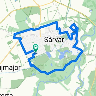
Ez a közepes nehézségű és hosszúságú útvonal, amely a Sárvártól délre, a Rába jobb partján elterülő tájat mutatja be, jól kombinálható a többi Sárvár-környéki körtúrával. Sárvárnál átkelünk a Rábán Sárvár-Hegyközségnél, majd délnek tartunk a 8439-es úton, Sótonynál felkapaszkodunk a dombon, majd Nyőgéren és Bejcgyertyánoson át ereszkedünk le Kámra. A benzinkúttól egy rövid szakaszon a 8-as utat követjük, majd letérünk jobbra, és leereszkedünk Csipkerekre és tovább Csehimindszentre, azután Mikosszéplakra. Itt a Rákóczi Ferenc utcán balra kanyarodunk, és eljutunk a festői Szajki-tavakhoz, ahol jó idő esetén mindenképp érdemes megállni egy pihenőre, és fürdeni egyet a strandon. Miután felfrissültünk, utunk Hosszúperesztegre vezet tovább, a falu elején visz út Bögötére, ahonnan két lehetőségünk van: vagy a közepes minőségű, kissé benőtt földúton érünk át Vashosszúfalu túloldalára, vagy pedig körülbelül 500 métert a 8-as úton haladva kanyarodunk rá Vashosszúfalura. A faluból egyenesen út vezet Káldra (innen opcionálisan letérhetünk a Hidegkúti Kisboldogasszony-kápolnához, majd Nyőgértől haladhatunk vissza a már ismert úton), majd Gércére, ahonnan a 87-es útra kanyarodva tekerhetünk be újra Sárvárra.
DE
Diese mittelschwere und mittellange Route südlich von Sárvár, die uns die Landschaft an den rechten Ufer der Rába präsentiert südlich von Rába am rechten Ufer der Landschaft liegt, lässt sich gut mit anderen Touren bei Sárvár zu kombinieren. Bei Sárvár überqueren wir die Rába (bei Sárvár-Hegyközség) und fahren weiter Richtung Süden auf der Autobahn 8439, bei Sótony fahren wir hin. auf den Hügel, und durch Nyőgér und Bejcgyertyános hinunter nach Kám. Wir folgen von der Tankstelle kurz die Straße 8, wonach wir nach rechts biegen, und hinunter nach Csipkerek und weiter nach Csehimindszent und Miklósszéplak fahren. Hier biegen wir an der Rákóczi Straße links und erreichen die malerischen Szajki Seen, wo es Wert ist eine Pause zu machen und am Strand baden falls wir gutes Wetter haben. Sobald wir uns erfrischt haben wührt unser Weg weiter nach Hosszúpereszteg, am Anfang des Dorfes führt uns die Straße nach Bögöte, wo wir zwei Möglichkeiten haben: entweder fahren wir bis die andere Seite von Vashosszúfalu auf einen Feldweg mittlerer Qualität, oder wir fahren etwa 500 Meter entlang der Straße 8 bis wir nach Vashosszúfalu kommen. Von dem Dorf führt ein direkter Weg nach Káld (optional fahren wir zu der „Hidegkúti Kisboldogasszony” Kapelle und aus Nyőgér kehren wir zurück auf den für uns schon bereits bekannten Weg) dann nach Gérce, wo wir auf die Straße 8 biegeen und zurück nach Sárvár fahren.
EN
This medium difficulty and length route show the landscape south of Sárvár on the right bank of Rába and it can be combined with other routes starting from Sárvár. Cross the Rába at Sárvár-Hegyközség than continue south on route 8439, climb the hill at Sótony and then go down to Kám through Nyőgér and Bejcgyertyános. Follow route 8 after the gas station then turn right towards Csipkerek and then Csehimindszent and Mikosszéplak. Turn left on Rákóczi Ferenc utca to reach the beautiful Szajki lakes where it is recommended to take a short brake and swim at the beach if the weather is good. After that continue towards Hosszúpereszteg and at the beginning of the village a road will take you to Bögöte. Here you have two options: either go to the other side of Vashosszúfalu on a medium quality dirt road or go 500 meters on route 8 to Vashosszúfalu. From the village go straight to Káld (here you can visit the Hidegkúti Kisboldogasszony chapel after which you can go back from Nyőgér on the same road) then to Gérce. After leaving Gérce follow route 87 back to Sárvár.
- -:--
- Duration
- 66.3 km
- Distance
- 311 m
- Ascent
- 468 m
- Descent
- ---
- Avg. speed
- ---
- Max. altitude

Route quality
Waytypes & surfaces along the route
Waytypes
Road
10.6 km
(16 %)
Track
7.3 km
(11 %)
Surfaces
Paved
31.2 km
(47 %)
Unpaved
7.3 km
(11 %)
Asphalt
31.2 km
(47 %)
Ground
6 km
(9 %)
Route highlights
Points of interest along the route

Point of interest after 0.7 km
HU Sárvár, kisvasút Sárvár, 9600 Magyarország +36 20 9367109 sarvarkisvonat@gmail.com http://sarvarkisvonat.hu/ 47.258683, 16.929451 Sihu, a városnéző kisvonat speciálisan a turisták számára gyártott, az európai igényeknek megfelelő közlekedési eszköz, amely önmagában is turistalátványosságnak számít. A kisvonat 2 kocsija 56 fő szállítására alkalmas. A kisvonat 13 km-t tesz meg a városban, körbejárva a legfontosabb látványosságokat. Az egyedi megrendelésre készült vonat zavartalan kikapcsolódást, felejthetetlen élményt nyújt mindenkinek. A teljes útvonal bejárása kb. 1 órát vesz igénybe. Az időjárás és a városi rendezvények miatti esetleges járatkimaradásokról a megállóhelyeken, illetve a facebook- és weboldalon lehet tájékozódni. DE Sárvár, kisvasút / Eisenbahn Sárvár Sárvár, 9600 Ungarn +36 20 9367109 sarvarkisvonat@gmail.com http://sarvarkisvonat.hu/ 47.258683, 16.929451 Sihu, der Besichtigung-Zug, wurde speziell für Touristen entwickelt und ist ein Transportmittel, das den europäischen Bedürfnissen entspricht, die auch selbst eine Touristenattraktion ist. Der Zug mit 2 Wagen kann 56 Passagiere auf einmal Transportieren. Seine Route ist 13 km lang, und geht neben den wichtigsten Sehenswürdigkeiten der Stadt vorbei. Der individuelle Zug bietet unvergessliche Erlebnisse für alle. Die vollständige Route dauert etwa 1 Stunde. Sie finden alle informationen auf den Wartestellen und auf Facebook. EN Narrow gauge railway of Sárvár Sárvár, 9600 Hungary +36 20 9367109 sarvarkisvonat@gmail.com http://sarvarkisvonat.hu/ 47.258683, 16.929451 Sihu, the small sightseeing train was specifically designed for tourists, and is vehicle fitting the European standard, that in itself is a tourist attraction. The two wagons are suitable for carrying 56 people. The train has a 13 kilometres long route in the city, passing by the most important spectacles. It was made for a custom order, and it provides an undisturbed relaxation and az unforgettable experience. Travelling the whole route takes up about an hour. About line cancellations due to weather or town events you can be informed at the stations, or at the facebook and webpage.

Point of interest after 4.1 km
HU Sárvári Horgásztó Sárvár, HRSZ 0306/21, 9600 Magyarország +36 30 839 5439 http://sarvarihorgaszto.hu/ 47.262332, 16.873541 A Sárvár Sziget Horgásztó Vas megyében a Sárvárt Szombathellyel összekötő 88. számú főút mellett található a porpáci leágazónál, Sárvártól 3 km-re. A horgásztó egy 15 hektáros területen fekszik, maga a tó 9 hektáros. Vize rendkívül tiszta, köszönhetően annak, hogy a tó vizének utánpótlását szűrt talajvíz biztosítja. A halak telepítése 2007-ben kezdődött, és napjainkban is intenzíven folyik. Fő halaink a ponty, amúr, dévérkeszeg, kárász, tokhal, compó. Ragadozóhalakból a süllő és a csuka a jellemző. A családos horgászok, társaságok kényelmét a 6 db 12 fős befogadó képességű esőbeállók is szolgálják, melyek padokkal és asztalokkal vannak ellátva. A tó körül kényelmes, nagyméretű padok, szemetesek vannak kihelyezve. DE Sárvári Horgásztó / Angelsee Sárvár Sárvár, HRSZ 0306/21, 9600 Ungarn http://sarvarihorgaszto.hu/ 47.262332, 16.873541 Die Insel Sárvár befindet sich in der Nähe der Hauptstraße Nr. 88, die Sárvár mit Szombathely im Komitat Vas verbindet, am Abzweig Porpáci, 3 km von Sárvár entfernt. Der Angelsee liegt auf einem 15 Hektar großen Gebiet, der See selbst ist 9 Hektar groß. Das Wasser ist sehr sauber, da das Wasser aus dem See mit gefiltertem Grundwasser versorgt wird. Die Fischerei begann im Jahr 2007 und wird bis heute intensiv betrieben. Unsere Hauptfische sind Karpfen, Graskarpfen, Brachsen, Karausche, Störe, Schleie. Von den Raubfischen: Zander, Hechte. Der Komfort von Familienanglern und Firmen wird durch 6 Regensätze mit 12 Plätzen, die mit Bänken und Tischen ausgestattet sind, geboten. Um den See gibt es große Bänke und Mülltonnen. EN Fishing Lake of Sárvár Sárvár, HRSZ 0306/21, 9600 Hungary +36 30 839 5439 http://sarvarihorgaszto.hu/ 47.262332, 16.873541 The Sárvár Island Fishing Lake is located in Vas county, next to the road 88 connecting Sárvár to Szombathely, by the branch-road of Porpág, 3 kilometres from Sárvár. The fishing pond lays on a 15 acres area, the lake itself is 9 acres big. The colonization of the fish began in 2007, and is still intensively going on today. Our main fish are the carp, the amur, the bream, the sturgeon and the tench. From prey fish bass and pike are most common. There are shelters, benches and tables around the lake.

Point of interest after 20.3 km
HU Wagner Lovaspanzió és Étterem Alsóújlak, Hársfa u. 17/6, 9842 Magyarország +36 94 371 099 E-mail: wagnerpanzio@gmail.com http://www.wagnerpanzio.hu/ 47.084567, 16.860891 Családias hangulatú, zöldövezetben, de könnyen megközelíthető helyen található panziónk egész évben szeretettel fogadja vendégeit. A panzió kiválóan alkalmas aktív és passzív pihenésre, kikapcsolódásra egyaránt. A panzió többféle lovas-programot kínál, de az idelátogatók számos környékbeli programlehetőség közül is választhatnak. A panzió a 8-as főút mentén található, minden irányból könnyen megközelíthető. Budapest és a rábafüzesi határátkelő felől a 8-as számú főúton, Szombathelyről a 87-es főúton (Vasváron át), Zalaegerszeg irányából a 74-es úton (Kámon keresztül) lehet eljutni hozzánk. DE Wagner Lovaspanzió és Étterem Alsóújlak, Hársfa u. 17/6, 9842 Magyarország +36 94 371 099 E-mail: wagnerpanzio@gmail.com http://www.wagnerpanzio.hu/ 47.084567, 16.860891 Familienfreundlich, im Grünen, aber sehr leicht zuganglich wartet unsere Panzion auf seine Gaste, das ganze Jahr über. Die Panzion ist perfekt für aktive, passive Erholung. Die Panzion bietet mehrere Pferdeprogramme an und in der Umgebung finden Sie viele Programmöglichkeiten. Die Pension liegt an der Hauptstraße Nummer 8, die aus allen Richtungen gut erreichbar ist. Von Budapest und vom Grenzübergang Rábafüzes erreichen sie uns von der Hauptstraße 8, von Szombathely auf der 87. Hauptstraße (durch Vasvár) und von Zalaegerszeg auf der Straße 74 (durch Kámon). EN Wagner Pension and Restaurant Alsóújlak, Hársfa u. 17/6, 9842 Magyarország +36 94 371 099 E-mail: wagnerpanzio@gmail.com http://www.wagnerpanzio.hu/ 47.084567, 16.860891 This pension is in a green area but still it is easily accessible and open all year long. It is great for both active and passive holidays: there are several riding programs and, in the area, there are a lot of other programs to choose from. It is located next to route 8 so it is accessible from any direction. From Budapest and the border at Rábafüzes you need to follow route 8, if coming from Szombathely follow route 87 (through Vasvár) and if coming from Zalaegerszeg follow route 74 (through Kám).

Point of interest after 23.2 km
HU Jeli Arborétum Kám, 47°04'20.4"N 16°53'52.6"E, 9841 Magyarország +36 94 572 060 E- mail: orbanl@vasvar.szherdeszet.hu http://www.jelivarazskert.hu/ 47.072350, 16.898255 A Jeli arborétum nem csak Magyarország, de Európa egyik legszebb botanikus kertje, különösen tavasszal (április-május), amikor virágzanak a rododendronok. A Vas megyei Kám község határában, több mint 100 hektáros területen egyedülálló gyűjteménnyel találkozhatunk a világ minden tájáról. Az arborétum építését dr. Ambrózy-Migazzi István gróf kezdte meg 1922-ben, aki a kor egyik legnagyobb botanikusa volt. Az arborétumnak három jól elkülönülő része van, így a park (fenyő-, nyír-, csarab-, és rododendron-gyűjtemény), az alátelepített erdei fenyves és a tájövezetek. Fő látványossága természetesen a világhírű rododendronjai, melynek 300 változata lelhető fel itt, virágzás idején pedig meseszép színkavalkáddal és elképesztő illatfelhővel borítják be az arborétumot. De említésre méltó az úgynevezett Óriások-erdeje is, melyben mamutfenyők állnak. Olyan ritka fajokkal találkozhat a látogató, mint a babérmeggy, a kínai mamutfenyő, az óriástuja, a japánciprus, a kaukázusi jegenyefenyő, nyírek kéttucatnyi változata és madárbirs fajok. DE Jeli Arborétum / Arboretum Jel Kám, 47°04'20.4"N 16°53'52.6"E, 9841 Ungarn +36 94 572 060 E- mail: orbanl@vasvar.szherdeszet.hu http://www.jelivarazskert.hu/ 47.072350, 16.898255 Das Jeli-Arboretum ist nicht nur Ungarn, sondern vor allem im Frühling (April-Mai), wenn die Rhododendren blühen, einer der schönsten botanischen Gärten Europas. An der Grenze des Dorfes Kám im Komitats Vas haben wir eine einzigartige Sammlung von über 100 Hektar aus der ganzen Welt. Mit dem Bau des Arboretums hat Graf dr. Ambrózy-Migazzi István im Jahre 1922 angefangen, er war einer der größten Botaniker seiner Zeit. Das Arboretum hat drei verschiedene Bereiche, darunter den Park (Kiefer, Birke, Rhabarber und Rhododendron), die untergepflanzten Föhrenwälder und die Landschaft. Seine Hauptattraktion sind natürlich die weltberühmten Rhododendren, deren 300 verschiedene Sorten hier zu finden sind, mit ihrem märchenhaften Farbraum und einem erstaunlichen Duft. Erwähnenswert sind aber auch die Wälder der Riesen mit Mammutbäumen. Es gibt seltene Arten wie Lorbeerkirschen, Urweltmammutbäume, Riesen-Lebensbäume, Sicheltannen mehrere Birken und Zwergmispeln arten. EN Jeli Arboretum Kám, 47°04'20.4"N 16°53'52.6"E, 9841 Hungary +36 94 572 060 E- mail: orbanl@vasvar.szherdeszet.hu http://www.jelivarazskert.hu/ 47.072350, 16.898255 The Jeli Arboretum is one of the most beautiful botanic gardens not only in Hungary, but in the whole of Europe, especially in spring (April and May), when the rhododendrons blossom. By the border of the village Kám of Vas County, we can find a unique collection from all over the world, on a 100 acres area. Dr. Ambrózy-Migazzi István count was the one who started building the arboretum in 1922, as one of the most famous botanists of the era. The arboretum has three distinct parts: the park (a collection of pine, birch, heather and rhododendron), the undergrown pine-plantation and the landscape zone. Its main spectacles are naturally its rhododendrons, with 300 types, filling the arboretum with beautiful colors and an amazing scent cloud when blossoming. But the so called Forest of the Giants should also be mentioned, in which we can find redwoods. Visitors can meet with rare species such as the laurel cherry, the chinese mammoth pine, the western redcedar, the cryptomeria, the Caucasian fir, and many types of birches and cotoneasters.

Point of interest after 23.3 km
HU Határmenti Vinotéka 9825 Oszkó, Molnár A. u. 4. Tel: +36 94 573 166 E-mail: vinoteka@oszko.hu Web: www.oszko.hu 47.046684, 16.874673 Az Oszkó község központjában kialakított Vinotékában közel 40 borász több mint 150 fajta borát kóstolhatják és vásárolhatják meg az érdeklődők. A bejelentkező csoportok számára bemutatásra kerülő borok és borászok négy nyugat-magyarországi borvidékhez (Balatonmelléke, Zala, Somló és Kőszeg-Vaskeresztes) tartoznak. A bejelentkező csoportok számára szakember által vezetett borkóstolókat szervezünk, igény esetén hideg vagy meleg étkezéssel. A program kiegészíthető szőlőhegyi sétával, ahol megismerhetik többek között többszáz éves présházainkat, a zsúpkészítés munkafázisait, kóstolhatnak helyi termékeket (pálinka, méz, lekvár, kemencében sült langalló stb.). Igény esetén szállást is tudunk biztosítani. DE Határmenti Vinotéka 9825 Oszkó, Molnár A. u. 4. Tel: +36 94 573 166 E-mail: vinoteka@oszko.hu Web: www.oszko.hu 47.046684, 16.874673 Die Vinotheke steht im Zentrum der Gemeinde Oszkó. Hier können Sie mehr als 150 verschiedene Weine von 40 Verschiedenen Winzern probieren und kaufen. Für die Gruppen präsentieren Winzer Weine aus 4 verschiedenen Weinregionen von West-Ungarn (Balatonmelléke, Zala, Somló, Kőszeg-Vaskeresztes). Wir arrangieren Weinproben, die von Weinexperten geführt werden, auf Anfrage mit kalten oder warmen Speisen. Das Programm kann durch einen Weinbergspaziergang ergänzt werden, auf dem Sie unsere jahrhundertealten Pressehäuser kennenlernen, die Arbeitsphasen der traditionellen Architektur kennenlernen und lokale Produkte probieren können (Brandy, Honig, Marmelade, gebackene Köstlichkeiten aus dem Ofen, usw.). Wir können auf Anfrage Unterkunft anbieten. EN Border Wine Store 9825 Oszkó, Molnár A. u. 4. Phone: +36 94 573 166 E-mail: vinoteka@oszko.hu Web: www.oszko.hu 47.046684, 16.874673 The Wine Store, established in the center of Oszkó, visitors can taste more than 150 wines of 40 oenologists. The groups that have appointment can taste and learn about four western vineyards (Balaton-side, Zala, Somló and Kőszeg-Vaskeresztes). We organize wine tasting for the groups which is lead by an expert but they can also take a walk on the hill to see the hundreds of years old press-houses or taste homemade products (palinka, honey, jam, langalló etc.). We can get accomodations too if needed.

Point of interest after 31.4 km
HU Mindszenty emlékház és múzeum Csehimindszent, Fő u. 34, 9834 Magyarország +36 30 416 4535 mindszenty.hu 47.045645, 16.955983 A hangulatos hegyháti településen az eredeti állapotába helyreállított Mindszenty József bíboros, hercegprímás szülői háza várja a látogatókat. Ma már az ország számos helyén szobrai állnak, nevét viselik utcák, terek és iskolák, az egyik legkülönlegesebb hely mégis Csehimindszent, a szülői ház, ahonnan élete indult. Mindszenty József szülői házában a bíboros hagyatékának jelentős darabjait mutatják be a közönség számára. A felújított emlékház és múzeum méltó környezetet ad a kiállított emléktárgyaknak. A kiállítás egyik legjelentősebb darabja egy feszület, amely sérüléseivel is a hercegprímás áldozatos életét idézi. DE Mindszenty emlékház és múzeum/ Gedenkhaus und Museum Csehimindszent, Fő u. 34, 9834 Magyarország +36 30 416 4535 mindszenty.hu 47.045645, 16.955983 In der charmanten Hügelsiedlung von Csehimindszent wartet auf uns das Haus wo Mindszenty József Kardinal und Erzbischof geboren ist. Das Haus wurde in seinen ursprünglichen Zustand versetzt. Heute kann man seine Statuen im ganzen Land betrachten, Straßen und Schulen tragen seinen Namen. Aber die besonderste Sehenswürdigkeit ist Immer noch sein Geburtshaus. In dem Elternhaus präsentieren wir für das Publikum bedeutende Stücke des Erbes des Kardinals. Das renovierte Haus und Museum bietet eine bemerkenswerte Umgebung für die ausgestellte Exemplare. Eines der wichtigsten Stücke der Ausstellung ist ein Kruzifix, das mit seinen Verletzungen an das Opferreiche leben des Kardinals erinnert. EN Mindszenty Memorial House and Museum Csehimindszent, Fő u. 34, 9834 +36 30 416 4535 mindszenty.hu 47.045645, 16.955983 The building where József Mindszenty archbishop was born awaits visitors in this small, athmospherical village. Many places commemorate him with sculptures, street or square names, schools – but the most original place is his family house in Csehimindszent, where his life started and where many of the objects he left behind are exhibited, including, above others, the wounded cross which resembles the heroic life of Mindszenty.

Point of interest after 37.6 km
HU Szajki tavak Hosszúpereszteg, Fürdő u. 10, 9676 Magyarország Tel: (95) 460-317 Web: http://www.szajkitavak.hu/ 47.055163, 17.009403 A Szajki-tavaknál egész évben lehetőség van igényesen berendezett, új apartmanok bérlésére. 2011-ben nyitott a Szajki-tavak Kalandpark. A park egy „nagy játszóteret”, erdei drótkötélpályákat takar, amelyben minden korosztály megtalálhatja a számára megfelelő élményt nyújtó szórakozási lehetőséget. Horgászási lehetőség a 4-5-ös számú tavakban (a fürdőtó mellett) 06-22 óra között van. A Szajki-tavaknál és környékén különböző túralehetőségek közül lehet választani. A gyermekek részére játszótér van kialakítva. A Szajki-tavak zöld strandja pedig nagy területen, árnyékot adó öreg fákkal várja vendégeit. DE Szajki tavak / Szajk Seen Hosszúpereszteg, Fürdő Straße 10, 9676 Ungarn Tel: (95) 460-317 Web: http://www.szajkitavak.hu/ 47.055163, 17.009403 Es besteht die möglichkeit das ganze Jahr über neue Apartmans am Szajk Seen zu vermieten. Im Jahr 2011 wurde der Abenteuerpark am Szajk Seen eröffnet. Der Park verfügt über einen "großen Spielplatz", bewaldete Drahtseilbahnen, auf denen sich jede Altersgruppe Unterhaltungserlebnis finden kann. Angelmöglichkeiten in den Teichen nr 4-5 (in der Nähe des Badesees) sind zwischen 06:00 und 22:00 Uhr vorhanden. In der Gegend gibt es ebenfalls verschiedene Wanderwege. Ein Kinderspielplatz ist auch vorhanden. Der grüne Strand der Szajk-Teiche bietet eine große Fläche von alten Bäumen. EN Lakes of Szajk Hosszúpereszteg, Fürdő u. 10, 9676 Hungary Tel: (95) 460-317 Web: http://www.szajkitavak.hu/ 47.055163, 17.009403 You can rent nicely furnished, new apartments near the Lakes of Szajk all year long. The Lakes of Szajk Adventure Park opened in 2011. In the park you can find a „big playground”, and forest wire rope trails, where people from all ages can find the right kind of fun for them. Fishing opportunities can be found in lakes number 4 and 5 (next to the bathing lake), between the hours of 6 and 22. Near the Lakes of Szajk and their surrounding you can choose from various hiking opportunities. There is a playground made for children. And the green beach of the Lakes awaits its visitors on a huge area, with old trees providing shadows.

Point of interest after 41.6 km
HU István-hegyi kilátó Bögöte, Rákóczi u. 8, 9675 Magyarország http://vulkansag.hu/TERMeSZET/Kilato.html 47.087643, 17.048841 A falu körül dél felől a Zalai-dombság, északról a Kemenes-vidék, a Ság hegy és a Kissomlyó vulkáni tömbje, nyugatról a Vasi-Hegyhát halmai emelkednek. Karnyújtásnyira tárul elénk a Somlói borvidék és a Bakonyi hegylánc. Lélekemelő pillanat körbetekinteni e tájon a kilátóból. 2001-ben Németh Attila tervei alapján épült meg a kilátó. A legenda szerint Berzsenyi Dániel többször is megfordult a településen, és egyik alkalommal niklai birtokára igyekezvén a jelenleg István-hegynek nevezett dombon írta a „Búcsúzás Kemenes-Aljától” című versét. DE István-hegyi kilátó / Aussichtsturm István Berg Bögöte, Rákóczi u. 8, 9675 Ungarn http://vulkansag.hu/TERMeSZET/Kilato.html 47.087643, 17.048841 Das Dorf umgibt vom Süden der Zala Hügel, nördlich das Kemenes Gebiet, der Ság Hügel und der Vulkanblock vom Kissomlyó, und die Hügel des Vasi-Hegyhát´s erheben sich aus dem Westen. Die Weinregion Somló und das Bakony Gebirge sind in Reichweite. Der Blick auf Landschaft hebt den Geist. Der Aussichtsturm wurde 2001 nach den Plänen von Németh Attila gebaut. Der Legende nach hat Dániel Berzsenyi die Siedlung besucht und einmal, als er auf dem Weg nach dem Anwesen von Niklai sich eielte, hatte er eine Pause auf dem István Hügel genommen und das Gedicht mit dem Titel „Búcsúzás Kemenes-Aljától” geschrieben. EN Viewpoint of the István Mountain Bögöte, Rákóczi u. 8, 9675 Hungary http://vulkansag.hu/TERMeSZET/Kilato.html 47.087643, 17.048841 The viewpoint was built according to the plans of Németh Attila, and looking around the view from here is a soul-lifting experience: around the village to the south there is the Zala Hills, to the north the Kemenes Province, the Ság Mountain and the volcanic block of the Kissomlyó, and to the west the piles of the Vas Ridge. According to the legend, Berzsenyi Dániel visited the village on several occasion, on one of which we wrote his poem „Búcsúzás Kemenes-Aljától” (Farewell to Kemenes-Alja) on the hill known today as István Mountain.

Point of interest after 46 km
HU Káld-hidegkúti Kisboldogasszony-kápolna Bejcgyertyános, 9683 Magyarország 47.161373, 16.980685 A Csikászó-patak közelében, a Hidegkúti vadászház mellett található a Szombathelyi Zrt. és a Földművelésügyi Minisztérium által felújított erdei kápolna. 2017. szeptember 8-án, Kisboldogasszony napján, Szűz Mária „születésnapján” adták át és szentelték fel. Az építtetők a kápolnát már a tervezéskor természeti környezetben, fákkal körülvett területen képzelték el, amivel egy többletjelentést is kapott a helyszín. Ahogy az ágak az égbe nyúlnak, úgy az idelátogatók is kapcsolatba kerülhetnek Istennel. A fák stabilan kapaszkodó gyökerei pedig az erős, mélyen ’gyökerező’ hitet szimbolizálják. Az erdei templom mennyezete maga az égbolt, díszítői pedig a felhők, a napsugarak, a madarak, a Hold és a csillagok. A kápolna központi részén láthatjuk a csíksomlyói zarándokhely Madonna-szobrának pontos, kicsinyített mását. Az alkotás jelképezi a szombathelyi és a csíkszeredai erdészet jó kapcsolatát, Vas megye és Hargita megye összetartását, valamint a nemzeti összetartozást is. DE Káld-hidegkúti Kisboldogasszony-kápolna/ Kapelle Bejcgyertyános, 9683 Magyarország 47.161373, 16.980685 In der nehe des Csikászó Baches, neben der Jägerhütte von Hiddegkút befindet sich die Kapelle, die mit der unterschtüzung von der Szombathelyi Zrt. und des Landwirtschaftsministeriums rekonstruiert wurde. Am 8. September 2017, am Tage der Heiligen Jungfrau Maria, wurde sie übergegeben und eingeweiht. Die Baumeister haben für die Kapelle einen natürlichen Austragungsort gewält, von Bäumen, und der Natur umgegeben. Wie die Äste in den Himmel ragen, kommen auch die Besucher in Kontakt mit Gott. Die festen Wurzeln der Bäume symbolisieren einen starken, tiefen Glauben. Das Dach des Waldtempels ist der Himmel selbst und seine Verzierungen sind Wolken, Sonnenstrahlen, Vögel, Mond und die Sterne. In der zentrale der Kapelle können wir die exacte, verkleinerte Kopie der Madonna Statue aus Csíksomlyó betrachten. Die Schaffung representiert die Guten verheltnisse zwischen den Waldwirtschafften von Szombathely und Csíksomlyó, die zusammenarbeit der Zwei Bezirke von Vas und Hargita, sowie die nationale Zugehörigkeit. EN Chapel of Nativity, Káld-hidegkút Bejcgyertyános, 9683 47.161373, 16.980685 The chapel, renovated by the Szombathely Corporatoin and the Ministry for Agriculture, situated close to the Csikászó Stream and neighbouring the Hidegkút Hunters’ House, was inaugurated on the „birthday” of the Holy Virgin, on 8th September 2017. The chapel is imagined as part of the nature with forest around: the trees reaching to the sky symbolize the possibility for the visitors to connect with God, while the roots of the trees symbolize the deep roots of faith. The ceilings of the church of the forest is the actual sky, with its ornaments: the clouds, the beams of the sun, the birds, the moon and the stars. The central area of the chapel features the exact copy of the sculpture of Madonna from Csíksomlyó, one of the most important pilgrimage destinations of Hungarian Catholics, which also symbolizes the connections between the forestries of Szombathely and Csíkszereda as well as the respective counties, Vas and Hargita.

Point of interest after 46.1 km
HU Sárvár Hidegkúti Vadászház Káld, 9673 Magyarország 47.162101, 16.982411 A Farkas-erdő szívében elhelyezkedő Káld-Hidegkúti Vadászházi komplexumba, az új vadászház és egy konferenciaépület tartozik. A vadászház 2000-ben készült el, hat zuhanyzós és/vagy fürdőkádas kétágyas szobával, valamint egy ugyancsak kétszemélyes lakosztállyal, magas színvonalú étkeztetést nyújtó konyhával várja a kedves vendégeket. Központi fűtéssel ellátott, helyben szauna szolgáltatás vehető igénybe. Teraszáról a piramistölgyekkel szegélyezett út mentén hosszan elnyúló tisztás látványában gyönyörködhet az itt megszálló. A több mint ötezer hektáros Farkas-erdő közepén épült létesítménytől több irányban tehet kellemes sétákat az itt pihenők. Legegyszerűbben a 84. sz. főút 56-os km-étől délnyugati irányba haladó - mintegy 6 km hosszúságú aszfaltozott erdészeti úton közelíthető meg. DE Sárvár Hidegkúti Vadászház/ Jagthaus Sárvár Hidegkút Káld, 9673 Ungarn 47.162101, 16.982411 Der Komplex Káld-Hidegkúti Vadászház (Jagthaus) im Herzen des Wolfswaldes (Farkas-erdő auf ungarisch) ist ein neues Jagdschloss und ein Konferenzgebäude. Das Jagdschloss wurde im Jahr 2000 erbaut und verfügt über sechs Doppel- und Doppelzimmer (für 1 oder 2 Personen) mit Dusche und / oder Badewanne sowie eine hochwertige Catering-Küche. Es gibt Zentralheizung mit Saunaservice. Von der Terrasse aus können Sie die Aussicht auf einen langen Weg entlang der Pyramide-Eichen (piramistölgy auf ungarisch) bewundern. In der Mitte des mehr als fünftausend Hektar großen Waldes von Farkas können Sie einen angenehmen Spaziergang machen. EN Hunter House of Sárvár Hidegkút Káld, 9673 Hungary 47.162101, 16.982411 The Hunter House Complex of Káld-Hidegkút is located in the heart of the Farkas-erdő (Wolf Forest), and it contains a new hunter house and a conference building as well. The hunter hourse was finished in 2000, with six two-bedded rooms with a shower and/or bathing tub, and also with a suite for two, and its kitchen awaits its visitors with high quality catering. The building has central heating, and you can also find a sauna here. The guests can rest their eyes on the view of the path and clearing embraced by pyramid oaks from the terrace. People relaxing here can take nice walk to various directions from the more than 5000 acres big establishment. It can be reached easiest from the 56th kilometre of the main road numbered 84 in a sounthwestern direction, on a 6 kilometres long asphalt forest road.

Point of interest after 46.7 km
HU Scherg Lőrinc Kilátó Káld, 9673 Magyarország 47.163650, 17.001874 A Farkas-erdő szélén álló szoknyás harangláb formájú faépület Káldról egyórányi kényelmes sétával bárki számára könnyen elérhető. 2015-ben a Föld napján, április 22-én adták át a kirándulóknak. A névadó Scherg Lőrinc az erdőgazdálkodásáról híres Bajorországból került hazánkba. A a XX. század elején a környék főerdésze, majd erdőmestere lett. Neki köszönhetjük, hogy a Farkas-erdő országos viszonylatban híres mintaerdővé vált. A faépület 201 méteren, a környék legmagasabb pontján áll. Teljes magassága 20 méter, a 12 méter magasan lévő kilátószint 12 méteres fölé egy tető került, amely alá szélsőséges időjárás esetén behúzódhatunk. Felkapaszkodva a lépcsőkön a Farkas-erdő keleti részét, a Kemensalját, a Kemeneshátat és a vulkáni eredetű tanúhegyeket (Púpos-hegy, Ság-hegy) csodálhatjuk meg. Az Országos Kéktúra útvonaláról kell rövid kitérőt tenni, hogy láthassuk a panorámát. DE Scherg Lőrinc Kilátó / Aussichtsturm Scherg Lőrinc Káld, 9673 Ungarn 47.163650, 17.001874 Das ziegelförmige Holzgebäude am Rande des Wolfswalds (Farkas-erdő) ist eine Stunde von Káld entfernt und bietet einen bequemen Spaziergang. 22. April 2015, am Tag der Erde wurde es am für die Besucher und Wanderer eröffnet. Lisztin Scherg, nachdem der Aussichtsturm benannt wuurde, kommt aus Bayern und ist für seine Waldbewirtschaftung bekannt. Zu Beginn des 20. Jahrhunderts wurde er Oberförster der Region und später Waldmeister. Dank ihm wurde der Wolfswald zu einem Nationalwald berühmter Wald. Das Holzgebäude befindet sich 201 Meter hoch, am höchsten Punkt der Gegend. Die Gesamthöhe des Hauses beträgt 20 Meter, die 12 Meter hohe Aussichtsplattform befindet sich 12 Meter über einem Dach, unter dessen wir bei extremen Wetterbedingungen uns verstecken können. Wenn Sie die Treppe hinaufsteigen, können Sie den östlichen Teil des Wolfswaldes, das Kemensalja, das Kemenesáta und die Vulkanberge (Púpos-Berg, Ság-Berg) bewundern. Um das Panorama zu sehen muss man einen kleinen Umweg von den Nationalen Blauen Tour (Országos Kéktúra) machen. EN Scherg Lőrinc Viewpoint Káld, 9673 Hungary 47.163650, 17.001874 The wooden building shaped like a skirted belfry located at the edge of the Farkas-erdő (Wolf Forest) can be easily reached with an hour long comfortable walk by anyone. It was opened in 2015, on the 22th of April, Earth Day. Scherg Lőrinc, its denominator, came to our contry from Bavaria, a place famous for its sylviculture. In the beginning of the 20th century he first became the chief forester, and then the forest master of the region. It was thanks to him that the Farkas-erdő (Wolf Forest) became a sample forest known trhoughout the country. The wooden building stands 201 metres high, on the highest point of the region. It is 20 metres high, and above its 12 metres high observation level they built a roof, under which we can hide in case of bed weather. After climbing the stairs we can admire the eastern part of the Farkas-erdő, the Kemenesalja, the Kemeneshát and the monadnock of volcanic origins (Púpos Mountain, Ság Mountain). We can view the panorama after taking a short bypass from the National Blue Trail.

Point of interest after 51.2 km
HU Termálfürdő-és Kemping Borgáta, Fürdő u. 1. Tel: 30/438-4827 E-mail: labirintus@freestart.hu Nyitva: Május 01-szeptember 30. 47.161674, 17.099631 A települést kitűnő termálfürdője tette ismertté. A falu közvetlen szomszédságában található fürdőcentrumban Önt is várjuk szolgáltatásainkkal. A Kissomlyó hegy lábánál fekvő termálfürdő 3 hektáros területével kitűnő lehetőséget nyújt a pihenni, szórakozni, valamint gyógyulni vágyóknak. 5 medencével, 28-38 fokos vízhőmérsékletű ásványi anyagokban gazdag termál, és strandmedencével várjuk kedves vendégeinket. DE Termálfürdő-és Kemping / Spa und Kemping Borgáta, Fürdő u. 1. Tel: 30/438-4827 E-mail: labirintus@freestart.hu Geöffnet: 01. Mai - 30. September 47.161674, 17.099631 Die Gemeinde wurde dank Ihres Thermalbades bekannt. In unmittelbarer Nähe des Dorfes begrüßen wir Sie auch mit unseren Dienstleistungen. Am Fuße des Kissomlyó-Berges bietet ein 3 Hektar großes Thermalbad eine großartige Gelegenheit zum Entspannen, zum Heilen und um Spaß zu haben. Die 5 Becken sind mit Mineralreichen warmen (28-38 °C) Wasser gefüllt. Im guten Wetter können sie auch unser Strandbecken benutzen. EN Thermal Bath and Camping Borgáta, Fürdő u. 1. Tel: 30/438-4827 E-mail: labirintus@freestart.hu Open: May 1-September 30 47.161674, 17.099631 The village was made famour by its wonderful thermal bath. Are services await you as well in the bathing centre near the village. The thermal bath located by the feet of the Kissomlyó Mountain, with its 3 acres gives a great opportunity to rest, have fun, and also to heal. We kindly invite our visitors to enjoy our 5 pools, with the thermal pool filled with 28-38 celsius water rich in minerals, and a swimming pool.

Point of interest after 56.2 km
HU Szent Kereszt Felmagasztalása Templom Gérce, Kossuth u. 235, 9672 Magyarország +36 95 476 120 https://www.gerceiplebania.hu/ 47.209476, 17.020955 Kora barokk eredetű templom, 1475-ben plébániaként szerepel. A török harcok után romosan megmaradt, régi, Szent Kereszt tiszteletére épített templomát a protestánsok használták. 1732-ig evangélikus lelkészek működtek a községben. 1735-ben renoválták, majd 1771-1777 között átépítették. 1860 körül alakították át romantikus stílusban, szentélyt építettek hozzá, falait és tornyát magasították. 1870-ben kőbástyával vették körül. DE Szent Kereszt Felmagasztalása Templom / Kirche Gérce, Kossuth u. 235, 9672 Magyarország +36 95 476 120 https://www.gerceiplebania.hu/ 47.209476, 17.020955 Die Frühbarockkirche, war schon in 1475 eine Pfarrgemeinde. Nach den türkischen Kämpfen wurde die protestantische Kirche zu Ehren des Heiligen Kreuzes und der alten Kirche errichtet. Bis 1732 waren im Dorf evangelische Pfarrer tätig. Sie wurde in 1735 renoviert und zwischen 1771 und 1777 wurden Veränderungen durchgeführt. Um 1860 wurde sie im romantischen Stil umgewandelt, ein Heiligtum wurde errichtet, die Mauern und der Turm wurden erhöht. Im Jahre 1870 wurde sie mit einer Steinbastei umgegeben. EN Church of the Glorified Holy Cross Gérce, Kossuth u. 235, 9672 Magyarország +36 95 476 120 https://www.gerceiplebania.hu/ 47.209476, 17.020955 This currently Early Baroque-Style church is noted already in 1475. After wars with the Ottomans, it remained in ruines and was used as such by the Protestants until 1732. It was renovated in 1735 and rebuilt between 1771-1777 and again around 1860 in romantic style. Its stone bastions were constructed in 1870.

Point of interest after 56.5 km
HU Gércei Evangélikus Templom Gérce, Kossuth u 88, 9672 Magyarország https://gerce.lutheran.hu/ 47.216485, 17.016551 A késő barokkstílusú templom Geschrey Sámuel építész tervei alapján 1794-ben, tornya 1795-1800 között épült. A keresztelőkút 1863-ból származik. A templom bemutatott berendezéseinél olvasható szövegek a Koczor György egykori gércei lelkész 1997. április 14-20. között tartott gyülekezeti evangelizációjára készült füzetből származnak. A templom tetőszerkezetét 2005-ben újították fel. A templom festett üvegablakait Lehoczky György készítette. DE Gércei Evangélikus Templom / Evangelische Kirche Gérce, Kossuth u 88, 9672 Magyarország https://gerce.lutheran.hu/ 47.216485, 17.016551 Die spätbarocke Kirche wurde in 1794 nach dem Plänen des Architekten Sámuel Geschrey erbaut , der Turm wurde zwischen 1795 und 1800 errichtet. Der Taufbrunnen stammt aus dem Jahr 1863Die Texte die man in der Kirche vorfinden kann stammen von Pastor György Koczor die er von dem 14. bis 20. April 1997 geschrieban hat, und der Evangelisierung dienten. Die Dachkonstruktion der Kirche wurde in 2005 erneuert. Die bemalten Glasfenster der Kirche wurden von György Lehoczky hergestellt. EN Lutheran Church of Gérce Gérce, Kossuth u 88, 9672 https://gerce.lutheran.hu/ 47.216485, 17.016551 Late Baroque Style church designed by Sámuel Geschrey, built between 1794-1800, renovated in 2005. The painted ornamentical windows of the church were made by György Lehoczky.

Point of interest after 57.6 km
HU Borostyánkert Étterem & Vendégház Sitke, Kossuth u. 21, 9671 Magyarország +36 95 442 284 german@borostyankert.hu http://www.borostyankert.hu/ 47.243641, 17.027774 A Borostyánkertben 60 fős étterem, 60 fős fedett terasz, 30 fős virágos, árnyas kerthelyiség, teke- és teniszpálya várja a pihenni, szórakozni és sportolni vágyó vendégeket. Étlapunkon mindenki találhat kedvére való fogásokat, házias jellegű konyhánkban kitűnő ételekből választhatnak vendégeink. Vendégházunkban 2-3-4 és 5 ágyas szobák, valamint egy földszinti, akadálymentesített 4 személyes apartman áll rendelkezésére. Családi vállalkozásunkat azért Sitkén nyitottuk, mert elvarázsolt bennünket a környék szépsége. A falu határán húzódó Hercseg-hegy a kápolnával, a községet körülölelő dombok és a távolban emelkedő Ság hegy. A környék gazdag gyógyvizekben. A falu határában vezet a kéktúra útvonala és a Mária-út. DE Borostyánkert Étterem & Vendégház Sitke, Kossuth u. 21, 9671 Magyarország +36 95 442 284 german@borostyankert.hu http://www.borostyankert.hu/ 47.243641, 17.027774 Im Borostyánkert gibt es ein Restaurant für 60 Personen, eine überdachte Terrasse für 60 Personen, einen blühenden schattigen Garten für 30 Personen. Eine Kegelbahn und ein Tennisplatz erwarten diejenigen die sich beim Sport entspannen möchten. Auf unserer Speisekarte findet sich Jeder was für ihn passt. Unsere gutbürgerliche Küche bietet hervorragende Speisen. Unser Gasthaus bietet 2-3-4 und 5 bettige Zimmer an, im Erdgeschoss steht ein 4 bettiges barierefreies Zimmer zur verfügung. Unser Familienunternehmen haben wir im Sitke gegründet, weil uns die Schönheit der Umgebung bezaubert hat. Die Hercseg-Kapelle an der Grenze des Dorfes, die umgebenden Hügel und der Ság-berg auf dem Horizont. Die Umgebung ist reich an Heilwasser. Es gibt auch Wanderwege, am Rande des Dorfes führt die Blaue-Route und der Marienwanderweg. EN Borostyánkert Restaurant and Guest House Sitke, Kossuth u. 21, 9671 Magyarország +36 95 442 284 german@borostyankert.hu http://www.borostyankert.hu/ 47.243641, 17.027774 Here there are a 60-person restaurant, a 60-person covered terrace, a 30-person shaded garden and a bowling and tennis course. Everyone can find what they like on the menu and everything is prepared here, in the kitchen. In the guest house, there are rooms with 2-3-4 and 5 beds and a wheelchair accessible apartman for 4 people on the ground floor. This family business was opened in Sitke, because the country here is beautiful. There is a chapel in Hercseg-hegy and the settlement is surrounded by hills. The blue trail and the Mária trail are also connecting to the village.

Point of interest after 57.6 km
HU Felsőbüki Nagy Sándor-kastély Sitke, József Attila u. 1, 9671 Magyarország +36 95 442 027 kfsitke@hu.inter.net http://www.sitkeikastely.hu/ 47.237016, 17.016618 Felújított, 300 éves barokk kastély - 6 hektáros park közepén -, amely ma egy családias jellegű fogadó Sitke község mellett, a Herceg-hegy északi oldalán. Az 1200-as években már egy több épületből álló vár volt itt, melyet az 1700-as évek elején a Felsőbüki Nagy család barokk stílusú kastélyépületként épített egybe, és jelenlegi formáját az 1851-ben romantikus stílusú átalakításban nyerte el. 1982-ben két vállalkozó szellemű család a Vas megyei kastélyprogram keretén belül vállalta, hogy felújítja. 1983-tól üzemel mint kastélyfogadó. Igazi családias hely, ahol a tulajdonosok régiséggyűjtési szenvedélye a legkülönbözőbb meglepetéseket varázsolja a kastély vendégei elé. A csendes parkban elhelyezkedő fogadó életét különböző programok gazdagítják, és túrázási lehetőségek várják. DE Felsőbüki Nagy Sándor-Schloss Sitke, József Attila u. 1, 9671 Magyarország +36 95 442 027 kfsitke@hu.inter.net http://www.sitkeikastely.hu/ 47.237016, 17.016618 Renovierte, 300 Jahre alte Barockvilla – in der Mitte von einem 6 Hektar Park – die heute als familienfreundliches Gasthof in der Nähe von Sitke auf der Nordseite des Herceg-Berges funktioniert. Im Jahre 1200 gab es schon eine Burg mit mehreren Gebäuden, die Anfang des 18. Jahrhunderts von der Familie Felsőbüki Nagy als Barockschloss neuerbaut wurde. Ihre heutige Form bekam sie im Jahre 1851 im romantischen Stil. Im Jahre 1982 verpflichteten sich zwei Familien, im Rahmen des Schloss Programs von Vas-Bezirk, das Schloss zu renovieren. Seit 1983 ist das Schloss für die Öffentlichkeit geöffnet. Ein wahrhaft familienfreundlicher Ort, an dem die Sammlelleidenschaft der Besitzer den Burggästen eine Vielzahl von Antiken Überraschungen bereitet. Das Leben des Gasthofes in dem ruhigen Park wird durch verschiedene Programme und Wandermöglichkeiten bereichert. EN Nagy Sándor-castle of Felsőbük Sitke, József Attila u. 1, 9671 Hungary +36 95 442 027 kfsitke@hu.inter.net http://www.sitkeikastely.hu/ 47.237016, 17.016618 A renovated, 300 years old baroque castle in the middle of a 6-hectar park that is now a family-friendly inn near Sitke on the north side of Herceg-hegy. In the 1200s it was already a multi-building castle that was built together as a baroque castle by the Nagy family of Felsőbük in the 1700s. Its current form was achieved in 1851. In 1982 two families bought it through the Vas county castle program and renovated it. It is a castle inn since 1983. A family-friendly place where the owners’ antique collection is the center of the inn. There are several programs and visitors can go hiking as well.

Point of interest after 58.5 km
HU Scherg Lőrinc erdőmester síremléke Bejcgyertyános, 9683 Magyarország 47.197312, 16.999120 Ezen a helyen nyugszik az a bajor származású erdész, akinek úttörő szerepe volt a magyar erdőgazdálkodás korszerűsítésében, modernizálásában. A Káld határában 2015-ben átadott kilátót is róla nevezték el. Az Országos Kéktúra útvonalán a Rózsáskerti erdészház melletti pecsételő helytől délnyugat felé indulva 300 métert sem kell megtennünk, amikor a balra kiágazó ösvényen egy emlékművet pillantunk meg. Itt talált végső nyugvóhelyre Scherg Lőrinc és felesége, Stegmüller Mariann. A sírhely fölött egy emléktábla hirdeti az erdész nagyságát, melyen a saját maga által írt sírfeliratot is olvashatjuk. A Sárvár környéki erdők Schergnek köszönhetik megújulásukat. Munkásságában összevetette a helyi viszonyokat a bajor erdőműveléssel és a külföldön tanultakkal, így alakította ki a bokros, ligetes, értéktelen területből az országos viszonylatban is híres Farkaserdőt. Scherg Lőrinc erdőmester síremléke / Grab Bejcgyertyános, 9683 Magyarország 47.197312, 16.999120 Hier liegt der bayerische Förster Lőrinc Scherg, dessen Arbeit zu der Modernisierung der ungarischen Waldwirtschaft viel zugetragen hat. Der Aussichtsturm der in der Grenze von Káld im 2015 errichtet wurde ist nach ihn benannt. Auf dem Kék Wanderweg von dem Rózsákert Waldhaus nur 300 Meter Süd-Westlich können wir das Denkmal betrachten. Hier kam Lőrinc Scherg und seine Frau Mariann zur letzter Ruhe. Über dem Grab befindet sich eine Gedenktafel, die über die Taten des Försters erzählt. Die Inschrift auf dem Grab stammt von dem Förster selbst. Die Wälder um Sárvar danken für ihre Erneuerung der fleißigen Arbeit von Scherg. In seiner Arbeit verglich er die örtlichen Gegebenheiten mit dem bayerischen Waldbau. Er nutzte seine Ausländischen Kenntnisse und so transformierte er den buschigen wertlosen Wald zum heutigen berühmten Farkaserdő. EN The Memorial Tomb of Forester Lőrinc Scherg Bejcgyertyános, 9683 47.197312, 16.999120 The tomb of Lőrinc Scherg and his wife, Mariann Stegmüller commemorates the Bavarian forester who had a huge role in the development and modernisation of forestry in Hungary. The memorial is located approximately 300 metres away from the National Blue Trail.

Point of interest after 64.7 km
HU Gyógy- és Wellnessfürdő Sárvár, Vadkert krt. 1, 9600 Magyarország +36 95 523 600 info @ sarvarfurdo.hu http://sarvarfurdo.hu/ 47.247371, 16.949250 A kiváló minőségű sárvári gyógyvízzel töltött medencékben a selymes víz átjárja a testet és lelket, feledtetve a hétköznapok gondjait, gyógyírt jelentve a fájó izületekre, reumatikus panaszokra. Az élménymedence vízbuzgárja, a vállmasszírozója, sodrófolyosója tökéletes kikapcsolódást kínál. Az új családi élményfürdőt tágas folyosó köti össze a gyógyfürdő szárnnyal. Itt már a legkisebbek is zavartalanul élvezhetik a pancsolás örömeit az év minden napján! Május elejétől szeptember végéig élvezhetik vendégeink a kellemes hőfokú szabadtéri medencékben a lubickolást. Óriáscsúszdák, különböző sportlehetőségek, játékok és animációs programok megannyi szórakozást kínálnak minden korosztály számára. Az exkluzív Szauna-világ a nyugalom oázisa: finn szaunák, soft szaunák, gőzfürdők, aromakabinok, Kneipp medence, élmény-zuhanyok és óriás jacuzzik gondoskodnak a testi-lelki felfrissülésről. A fürdő – a sok egyéb kitüntetés között - elnyerte az EuropeSpa-med minőségi díját is. A díj egy minőségi elismerés, melyet előre meghatározott feltételek teljesülése esetén az Európai Fürdőszövetség ad ki, ez is jelzi, hogy nem hiába kapott helyet Európa TOP 5 gyógyfürdője között. DE Gyógy- és Wellnessfürdő/ Spa und Wellness Center Sárvár, Vadkert krt. 1, 9600 Magyarország +36 95 523 600 info @ sarvarfurdo.hu http://sarvarfurdo.hu/ 47.247371, 16.949250 In Becken mit hochwertigem Heilwasser strömt das seidiges Wasser durch Körper und Seele, hier vergisst man die Probleme des Alltags, das Wasser heilt Gelenkschmerzen und ist gut für rheumatische Beschwerden. Die Wasserbetten des Erlebnisbades, das Schultermassagegerät und der schwingende Wassergang sorgen für perfekte Entspannung. Das neue Familienerlebnisbad ist durch einen großen Flur mit der Spa verbunden. Hier können auch die Kleinsten jeden Tag die Freude des Wassers genießen! Von Mai bis Ende Septembers können unsere Gäste in den angenehmen Thermalbecken im Freien schwimmen. Riesenrutschen, verschiedene Sportarten, Spiele und Animationsprogramme bieten Spaß für jede Altersgruppe. Die exklusive Saunawelt ist die Oase der Ruhe: Finnische Saunen, Softe Saunen, Dampfbäder, Aromakabinen, Kneippbecken, Duschen und riesige Whirlpools sorgen für Körper und Seele. Der Spa gewann - neben vielen anderen Auszeichnungen - auch den EuropeSpa-med Qualitätspreis. Der Preis ist eine Auszeichnung, die von der European Bath Association unter vorgegebenen Bedingungen vergeben wird. Dies bedeutet auch, dass der Platz in Europas TOP 5-Spa-s verdient war. EN Spa and Wellness Bath Sárvár, Vadkert krt. 1, 9600 Hungary +36 95 523 600 info @ sarvarfurdo.hu http://sarvarfurdo.hu/ 47.247371, 16.949250 Water flows through body and soul in the pools filled with premium sarvarian mineral water, washing away the everyday troubles, healing the aching joints and rheumatic pains. The water spring, shoulder massager and water course of the fun pool offer perfect recreation. The new family-friendly fun pool is connected to the spa wing through a wide corridor. Here even the smallest ones can enjoy the pleasures of splashing about, all year long! Our guests can enjoy paddling in the outdoor pools with pleasant temperatures from the beginning of May till the end of September. Giant slides, various sporting opportunities, games and other programs offer endless fun for all ages. The exclusive Sauna-world is the oasis of peace: Finnish saunas, soft saunas, steam baths, aromatic cabins, a Kneipp pool and large jacuzzis maintain the recreation of body and soul. The spa – among with many other prizes – won the EuropeSpa-med quality award. This award is a quality recognition given out by the European Spa Assosiation, based on predetermined criteria. This is also an indication that it was not in vain that the Spa got a place between the TOP 5 Spas of Europe.

Point of interest after 64.7 km
HU Vadkert Major Sárvár, Vadkert krt. 2, 9600 Magyarország +36 30 683 7508 vadkert@vadkertmajor.hu http://www.vadkertmajor.hu/ 47.244246, 16.946675 Az első írásos feljegyzések a Vadkertről az 1600-as évek tájára tehetők. Ezidőtájt – a Nádasdyak idején – már fővadász felügyelte ezt a területet ahol darvak, szarvasok, őzek, dámvadak, vidra, hód, nyúl és vadkecske volt fellelhető. 1750-et írunk, amikor magyar főnemesi családok már lovakat is tartanak itt. 1803–ban alapítja meg a mai ménes elődjét IV. Ferenc modenai herceg. A majorsági épületegyüttest a XIX. sz. második felében emelte az örökös Lajos bajor királyi főherceg. A régi épületek átgondolt rekonstrukciójával alakítottuk ki kényelmes, XXI. századi igényszintű szállodánkat. A Vadkert Hotel épületei: a Vadászház, a Csikósház és a Magtár különböző szobatípusokkal várja a pihenni vágyó vendégeket. Nálunk a festői környezetben lehetőség van kempingezésre is. DE Vadkert Major Sárvár, Vadkert krt. 2, 9600 Magyarország +36 30 683 7508 vadkert@vadkertmajor.hu http://www.vadkertmajor.hu/ 47.244246, 16.946675 Die ersten schriftlichen Aufzeichnungen von Vadkert kann man auf 1600 datieren. In dieser Zeit – in der Zeit der Nádasdy Familie – galt das Gebiet als Jagdgebiet wo man auf Kräne, Hirsche, Damhirsche, Otter, Biber, Hasen, wilde Ziegen stoßen konnte. Wir schreiben das Jahr 1750, in dieser Zeit haben die Ungarischen adeligen Familien schon Pferde gehalten. Im Jahre 1803 hat IV. Franz der Prinz von Modena den Vorgänger der häutigen Stuterei gegründet. Die Gebäude des Gutshofes hat der Erbe Ludwig, Bayerischer Erzherzog in der zweiten hälfte des XIX. Jahrhunderts bauen lassen. Die durchgedachte Rekonstruktion von den Alten Gebäuden bietet Ihnen eine gemütliche Unterkunft an, würdig des XXI. Jahrhunderts. Die Gebäude des Vadkert Hotels: Das Jagdhaus, das Pferdehaus und das Getreidespeicher erwarten die Gäste mit unterschiedlichen Zimmertypen. In unserer malerischen Umgebung ist auch Camping möglich. EN Vadkert Major Sárvár, Vadkert krt. 2, 9600 Magyarország +36 30 683 7508 vadkert@vadkertmajor.hu http://www.vadkertmajor.hu/ 47.244246, 16.946675 The first written records of Vadkert date back to the 1600s when already a master of foxhounds oversaw the area where cranes, deers, otters, beavers, rabbits and wil goats lived in the wild. In 1750 the Hungarian noble families had horses here. In 1803 IV. Ferenc, the prince of Modena established the herd that is still there today. The Major was built by Lajos Bavarian royal archduke in the 19th century. The hotel was built by the reconstruction of these old buildings to serve the needs of the 21st century. The buildings of Vadkert Hotel have different kind of rooms for the guests. It is possible to camp here too.

Point of interest after 65 km
HU Sárvári Kalandpark Sárvár, Vadkert utca 1, 9600 Magyarország +36 20 244 2127 https://www.sarvarikalandpark.hu/ 47.245248, 16.945184 120 állásos erdei kötélpályánk két oktató; két kisgyermek; három gyermek és 4 felnőtt pályából áll. A patkótó fölötti átcsúszások, a 8 méter magasban lévő valódi erőpróbát jelentő akadályok még a legbátrabbakat is próbára teszik. A kötélpályák kialakításuknak köszönhetően különböző módon dolgoztatják meg a parkba érkező kihívást keresőket. Minden kötélpályázni vágyó vendégünk szakszerű öltöztetésben és oktatásban részesül az egyéni vagy csoportos felelősségvállalási és hozzájáruló nyilatkozatok kitöltése után. A szikla és falmászás kedvelők örömére készült egy 10 méter magas mászófal. Történelmünk hagyományait nem feledve tradicionális íjászattal is megismerkedhetnek a hozzánk érkező vendégeink. A Kalandpark erdei Tanösvényén és bővíthetjük ismereteinket az erdő és a tó növény- és állatvilágával kapcsolatban. A kicsik örömére mesebeli szereplők megformálásával készült játszóterünk. DE Sárvári Kalandpark/Abenteuerpark Sárvár, Vadkert utca 1, 9600 Magyarország +36 20 244 2127 https://www.sarvarikalandpark.hu/ 47.245248, 16.945184 Unsere Kletterbahn hat 2 Trainings-, 2 Kleinkinder-, 3 Kinder- und 4 Erwachsene Strecken. In 8 Meter höhe, stellen die Hindernisse auch die mutigsten zum Test. Die Seilstrecken dank ihrer entwerfung trainieren den ganzen Körper durch. Alle unsere Gäste werden professionell gekleidet und trainiert, nachdem sie ein Verantwortungsformular ausgefüllt haben, kann der Spaß beginnen. Für Kletterfans wurde eine 10 Meter hohe Kletterwand gebaut. Um unsere Geschichte nicht zu vergessen, können Besucher das traditionelle Bogenschießen ausprobieren. Auf unserer Naturlehrpfad können wir unser Wissen über die Flora und Fauna des Waldes und des Sees erweitern. Für die Kleinen haben wir unseren Spielplatz mit Märchenfiguren dekoriert. EN Adventure Park of Sárvár Sárvár, Vadkert utca 1, 9600 Hungary +36 20 244 2127 https://www.sarvarikalandpark.hu/ 47.245248, 16.945184 Our forest ropeway consists of two instructional courts, two courts for small children, another three for children and four courts for adults. The 8 metres high ropes above the Patkó Lake are a challenge for even the bravest adventurers. Thanks to the shaping of the ropeways, the visitors can be challenged in many different ways. After filling out the responsibility and consent declarations, all our visitors get proper equipment and training. Much to the delight of those who enjoy rock and wall climbing, we have a 10 metres high climbing wall. To stay true to our history and traditions, we also provide an opportunity for our visitors to get to know traditional archery. We can widen our knowledge about the flora and fauna of the forest and lake on the forestal educational trail of the adventure park. Small children can enjoy our playground formed with fairy tale characters.

Point of interest after 65.4 km
HU Városi csónakkölcsönző Sárvár, Alkotmány u. 16, 9600 Magyarország +36 70 365 1833 http://sarvar.hu/info/szabadido/zoldelmenyek/csonakazoto.html 47.246646, 16.940504 A termálfürdőhöz közel 9 hektárnyi vízfelületű, négy részből álló tórendszer található, ahol nyáron csónakázni, télen korcsolyázni és szánkózni is lehet. A tórendszer szinte teljes egészében körbejárható, az öt szigetet öt híd köti össze és teszi igazán hangulatossá. A hozzánk érkező turisták szívesen csónakáznak itt a nyári estéken, a sportosabb vendégek pedig reggelente általában itt futnak. De nem csak aktív időtöltésre alkalmas a csónakázó tó és környéke. Relaxálni, a vízi madarakat megfigyelni és horgászni is lehet itt. DE Városi csónakkölcsönző / Bootsverleih Sárvár, Alkotmány u. 16, 9600 Magyarország +36 70 365 1833 http://sarvar.hu/info/szabadido/zoldelmenyek/csonakazoto.html 47.246646, 16.940504 Zum Thermalbad gehört auch ein Teich Komplexum mit einer Pfläche von 9 Hektar. Im Sommer kann man Bootfahren, im Winter Schlittschuhlaufen und Rodeln. Das Teich Komplexum hat 5 Inseln die mit Brücken verbunden sind das macht den Ort einzigartig. Touristen, die uns besuchen, können an Sommerabenden hier Bootfahren gehen, während die sportlicheren Gäste morgens hier laufen. Bei uns haben Sie die Gelegenheit sich Aktiv zu erholen oder nur die Natur genießen und Angeln gehen. EN City Boat Rental Sárvár, Alkotmány u. 16, 9600 Hungary +36 70 365 1833 http://sarvar.hu/info/szabadido/zoldelmenyek/csonakazoto.html 47.246646, 16.940504 Near the thermal bath there is a lake system of four lakes on a 9 acre area, where in the summer the visitort can boat around, and in the winter they can skate on the surface and also sled in the area. You can almost entirely walk around the whole lake syste, the five islands are connected by five bridges, which gives it a very unique atmoshpere. The tourists visiting us like boating around in the area on summer evenings, and the more sportive guests usually do their morning run around here. But the lake and its surrounding is not only suitable for active leisure. You can also just relax, watch the water birds, or fish.

Point of interest after 65.5 km
HU Sárvári arborétum Természetvédelmi terület Sárvár, Várkerület u. 30/A, 9600 Magyarország +36 95 320 070 E-mail: erti@erti.hu http://www.sarvarvaros.hu/sarvari_arboretum 47.253258, 16.939469 A Nádasdy-vár szomszédságában helyezkedik el a 9,2 hektár területű arborétum, ami országos jelentőségű védett természeti terület. Vas megye arborétumai közül a legelső írásos emlékek Sárváron fedezhetők fel. A mai arborétum elődjét 1546-ban alapították, gyümölcsös és zöldséges kertként. A kertészkedés egészen 1671-ig virágzott, amikor III. Nádasdy Ferencet lefejezték és birtokait elkobozták. Ezzel a híres kertészet tönkrement, de néhány gyümölcsfa és közé keveredett tölgy megőrizte a kezdetek emlékét. Az arborétum növényanyagát és tájképét tekintve alapvetően két részre osztható. Az egyik, az egykori ártéri keményfás ligeterdő maradvány. Itt 400 éves ősi kocsányos tölgyek, magas kőrisek és szálanként megmaradt, de jobbára csak fiatalabb mezei szil példányok uralják a területet. Az arborétum másik részén a 200 évvel ezelőtt megkezdett angolpark alapjain alakult ki a mai összkép. A tájképet a legidősebb, mintegy 200 éves platánok, fekete fenyők, tiszafák, japán akácok, vasfák és egy hatalamas egylevelű magaskőris uralják. A későbbi telepítések közül a 100-130 éves liliomfák hívják fel leginkább magukra a figyelmet, de sokféle rododendron és azálea faj is található itt. DE Sárvári arborétum Természetvédelmi terület / Arboretum Naturschutzgebiet Sárvár Sárvár, Várkerület u. 30/A, 9600 Ungarn +36 95 320 070 E-mail: erti@erti.hu http://www.sarvarvaros.hu/sarvari_arboretum 47.253258, 16.939469 Neben dem Schloss Nádasdy befindet sich das 9,2 Hektar große Arboretum, ein nationales Naturschutzgebiet. Unter den Arboreten des Komitats Vas können die ersten schriftlichen Erinnerungen in Sárvár finden. Der Vorgänger des heutigen Arboretums wurde 1546 als Obst- und Gemüsegarten gegründet. Der Gartenbau blütete bis 1671, als III. Ferenc Nádasdy geköpft wurde und sein Eigentum konfisziert wurde. Damit war der berühmte Gartenbau ruiniert, aber einige der mit ihnen vermischten Obstbäume und Eichen behielten die Erinnerung des Anfangs. Das Pflanzenmaterial und die Landschaft des Arboretums können in zwei Teile unterteilt werden. Der erste Teil, wo sich die Rückstände des alten Hartholzwaldes befinden der in einer Aue lag. Hier kann man 400 Jahren alte Stieleichen, Gemeine Eschen sowie auch jüngere Feldulmen arten. Im anderen Teil des Arboretums begann vor 200 Jahren das aktuelle Bild des englischen Parks. Die Landschaft wird von den ältesten, etwa 200 Jahre alten Platanen, schwarzen Kiefern, Eiben, japanischen Akazienbäumen, Eisenbäumen und einem mächtigen, einflügeligen Magma (egylevelű magaskőris) dominiert. Von den späteren Pflanzungen sind die 100-130 Jahre alten Lilienbäume die bekanntesten, aber es gibt auch viele Rhododendron- und Azaleenarten. EN Arboretum of Sárvár Nature Reservation Sárvár, Várkerület u. 30/A, 9600 Hungary +36 95 320 070 E-mail: erti@erti.hu http://www.sarvarvaros.hu/sarvari_arboretum 47.253258, 16.939469 The 9,2 acres big arboretum is situated next to the Nádasdy Castle, and it is a protected natural area of national significance. Out of the arboretums of Vas County the first written memories are those from Sárvár. The ancestor of today’s arboretum was founded in 1546, as a fruit and vegetables garden. It blossomed until the decapitation of III. Nádasdy Ferenc, until his assets were confiscated. The arboretum can be divided into two parts based on its flora and landscape. First is the remains of the former floodplain grove forest. The other one was formed on the basics of the English park formed 200 years ago.

Point of interest after 66 km
HU Nádasdy-vár Sárvár, Várkerület u. 1, 9600 Magyarország +36 95 320 158 info@sarvarvar.hu http://sarvarvar.hu/ 47.253139, 16.937088 A sárvári vár egy teljes épségben megmaradt középkori vár Sárváron, a Rába folyó nyugati partjának közelében. A vár első írásos említése 1327-ből maradt fenn, amikor is a vár Károly Róbert királyi birtoka volt. 1424-től Kanizsai-birtok, majd Kanizsai Orsolya férje, Nádasdy Tamás kapta meg. A következő évtizedekben Sárvár lett a központja a szépen gyarapodó Nádasdy család uradalmainak. A török rablóportyák elleni védelmül 1549 és 1562 között fokozatosan kiépítették a sárvári véghelyet, melynek öt olasz bástyás erődítményét széles vizesárok oltalmazta; ma is ezek határozzák meg az építmény formáját. Sárvár földesura, III. Nádasdy Ferenc az országbírói hivatalt viselte. Ő építtette a kastély fő látványosságának tartott dísztermet, aminek mennyezeti freskói 1653-ra készültek el. A főnemes azonban belekeveredett a Habsburg császári ház elleni Wesselényi-féle összeesküvésbe – Ferenc országbírót társaival együtt lefejezték, óriási birtokait elkobozták. Sárvárt gróf Draskovich Miklós vásárolta meg. Ezután az Esterházy főnemesi família szerezte meg. Utóbb a Wittelsbach család birtokolta 1945-ig. DE Nádasdy-Burg Sárvár, Várkerület u. 1, 9600 Magyarország +36 95 320 158 info@sarvarvar.hu http://sarvarvar.hu/ 47.253139, 16.937088 Die Burg Sárvár ist eine vollständig erhaltene mittelalterliche Burg in Sárvár, am westlichen Ufer des Flusses Rába. Die erste schriftliche Erwähnung des Burgs stammt aus dem Jahr 1327, von der Zeit vom Károly Róbert. Ab 1424 gehört das Gut der Familie Kanizsai, nächst der Besitz von Tamás Nádasdy den Ehemann von Orsolya Kanizsai. In den nächsten Jahrzehnten wurde Sárvár zum Zentrum der schön wachsenden Familie Nádasdy. Um sich von dem türkischen Räuberangriffen zu schützen, wurde die Grenze von Sárvár schrittweise, von 1549 bis 1562 ausgebaut. Fünf italienische Bastionen wurden durch breite Wassergraben geschützt. Auch Heute bestimmen sie die Form des Gebäudes. Gutsherr von Sárvár, III. Nádasdy Ferenc war oberster Kronrichter Ungarns. Er lasse den Saal erbauen der heute als die Hauptattraktion des Burgs gilt, dessen Deckenfresken im Jahre 1653 gemalt wurden. Später nahm er teil in der scheiterten Wesselényi-Verswörung gegen die Habsburger. Er wurde geköpft und seine riesigen Grundstücke wurden konfisziert. Graf Draskovich Miklós hat Burg Sárvár gekauft. Danach erhälte die Burg die Familie Esterházy, nächst war sie das Eigentum der Familie Wittelsbach bis 1945. EN Nádasdy-castle Sárvár, Várkerület u. 1, 9600 Hungary +36 95 320 158 info@sarvarvar.hu http://sarvarvar.hu/ 47.253139, 16.937088 The castle of Sárvár has been remaining intact since the middle ages near the west bank of Rába. The first written record of the castle is from 1327 when it was the property of King Róbert Károly. From 1424 it is a Kanizsai property then the husband of Orsolya Kanizsai, Tamás Nádasdy became the owner. In the next decades it became the center of the Nádasdy family. To defend it against the Turkish robber raids they developed a border with five bastions and a gutter. The owner, III. Ferenc Nádasdy was the national judge. He built the huge salon; its ceiling frescos were finished in 1653. The judge became a part of the Wesselényi conspiracy aginst the Habsburgs and he was beheaded. Sárvár was purchased by count Miklós Draskovich then the noble family Esterházy. After that it was the property of the Wittelsbach family until 1945.

Point of interest after 66 km
HU Evangélikus templom Sárvár, Sylvester János utca 5., 9600 Magyarország https://sarvar.lutheran.hu/ 47.253750, 16.936827 A XVI. század második felére Sárvár az egész Dunántúl evangélikus központja lett: 1534-1541 között Sárváron készíti el Sylvester János az első magyar nyelvtant és az első teljes Újszövetség-fordítást. 1576-tól evangélikus püspöki székhely. A török kiűzését követően a Habsburg-ház a római katolikus restaurációt támogatta. A városban nem élhettek evangélikusok, a környező falvak evangélikussága pedig csak a 25 km-re lévő nemesdömölki gyülekezetben gyakorolhatta vallását. A türelmi rendelet kiadását követően 1782-1787 között épülhetett meg az új templom Geschrey Sámuel tervei alapján. Az 1829-es tűzvész után 1836-ban szentelték fel a gyülekezet mai életét szolgáló harmadik templomot. DE Evangélikus templom / Kirche Sárvár, Sylvester János utca 5., 9600 Magyarország https://sarvar.lutheran.hu/ 47.253750, 16.936827 In der zweiten helfte des XVI. Jahrhunderts wurde Sárvár zum evangelischen Zentrum von ganz Transdanubien. Von 1534 bis 1541 hat Sárvári Sylvester das ganze Neues Testament auf ungarisch übergesetzt und die Grundsteine der ungarischen Grammatik gelegt. Von 1576 wurde sie zum Lutheranen Bischofssitz. Nach der Vertreibung der Türken unterstützte das Habsburgerhaus die römisch-katholische Restauration. Es gab keinen evangelischen Gottesdienst in der Stadt, und die nächste evangelische Kirche war 25 km entfernnt. Nach dem Toleranzpatent wurde eine neue Kirche zwischen 1778 und 1782 nach den Plänen von Geschrey Sámuel errichtet. Nach dem Brand im Jahr 1829 wurde die Kirche in 1836 eingeweiht. EN Lutheran Church Sárvár, Sylvester János utca 5., 9600 Magyarország https://sarvar.lutheran.hu/ 47.253750, 16.936827 Sárvár became the center of the Lutherans in West Pannonia by the second half of the 16th century: scholar János Sylvester created the first Hungarian Grammatics and complete Hungarian translation of the New Testament here, between 1534 and 1541. The Lutheran bishop seated here since 1576. After the reconquest from the Ottomans, the city was not allowed to have Lutheran citizens and services were moved to the Nemesdömölk Church 25 kilometers away. The new Lutheran Church was only to be built between 1782-1787 by the plans of architect Sámuel Geschrey. The city burned down in 1829 – the third and still standind third Lutheran church was inaugurated in 1836.

Point of interest after 66.1 km
HU Szent László király templom Sárvár, Kossuth tér, 9600 Magyarország +36 95 320 051 47.253682, 16.935222 A több fázisban épült templom végső, ma látható formáját az 1927-ben befejezett átépítés és bővítés során nyerte el. Feltételezhető ugyan, de egyelőre nem bizonyított, hogy a XVI. században is már templom állt ezen a helyen, azonban későbbi írásos források alapján feltételezhető egy protestáns fatemplom megléte. Nádasdy III. Ferenc 1643-ban birtokain templomok építésébe vagy felújításába kezdett. 1645-ben kezdte meg a sárvári felújítását, azonban a XVIII. század eleji tűzvészek miatt a belső felszerelés elenyészett, és csupán a falak maradtak meg. Az épület felújítására csak három évtized múltán került sor 1732-ben. DE Szent László király templom / Kirche Sárvár, Kossuth tér, 9600 Magyarország +36 95 320 051 47.253682, 16.935222 Die endgültige, jetzt sichtbare Form hat die Kirche während des Wiederaufbaus und der Erweiterung von 1927 gewonnen. Wir können davon ausgehen das schon im 18. Jahrhundert hier eine Kirche stand, aber wir haben keinen direkten beweis, jedoch manche Quellen erzehlen das hier eine Holzkirche gab. III. Nádasdy Ferenc begann in 1643 mit dem Bau oder der Renovierung von Kirchen auf seinem Gut. Im Jahr 1645 begann er mit der Renovierung von Sárvár. Im 18. Jahrhundert Aufgrund der Brände wurde die Innenausstattung zerstört und nur die Wände blieben. Das Gebäude wurde erst in 1732 nach drei Jahrzehnten saniert. Die heute zu sehenden Fresken wurden in 1938/39 von Z. Soós István angefertigt. EN Church of King St. László Sárvár, Kossuth tér, 9600 +36 95 320 051 47.253682, 16.935222 The church was built in several phases, gaining its current form in 1927 after renewal with additions. It is not proven, but according to later written sources, it can be assumed that there was a wooden Protestant church standing here already in the 16th century. Ferenc III Nádasdy started building and renewing churches on his lands in 1643. He started the renovation of the Sárvár one in 1645, but the enterieur was destroyed in a number of fires in the early18th century, leaving only the walls stand. Renovarion of the building was not accomplished until 1732. The frescoes decorating the walls today were painted by István Z. Soós in 1938-39.
Continue with Bikemap
Use, edit, or download this cycling route
You would like to ride VELOREGIO_17 or customize it for your own trip? Here is what you can do with this Bikemap route:
Free features
- Save this route as favorite or in collections
- Copy & plan your own version of this route
- Sync your route with Garmin or Wahoo
Premium features
Free trial for 3 days, or one-time payment. More about Bikemap Premium.
- Navigate this route on iOS & Android
- Export a GPX / KML file of this route
- Create your custom printout (try it for free)
- Download this route for offline navigation
Discover more Premium features.
Get Bikemap PremiumFrom our community
Other popular routes starting in Sárvár
 Farkaserdő II
- Distance
- 38.7 km
- Ascent
- 136 m
- Descent
- 133 m
- Location
- Sárvár, Vas County, Hungary
 VELOREGIO_02.
- Distance
- 181.1 km
- Ascent
- 227 m
- Descent
- 224 m
- Location
- Sárvár, Vas County, Hungary
 VELOREGIO_10.
- Distance
- 20 km
- Ascent
- 20 m
- Descent
- 22 m
- Location
- Sárvár, Vas County, Hungary
 Ungarntour etappe 3 Sarvar-Balatonfüred gps
- Distance
- 142.2 km
- Ascent
- 587 m
- Descent
- 621 m
- Location
- Sárvár, Vas County, Hungary
 Sárvár - Szeleste arborétum
- Distance
- 30.6 km
- Ascent
- 52 m
- Descent
- 49 m
- Location
- Sárvár, Vas County, Hungary
 1989 - In den Südosten Europas - 05. Tag - Sárvár - Balatonföldvár
- Distance
- 113.6 km
- Ascent
- 361 m
- Descent
- 408 m
- Location
- Sárvár, Vas County, Hungary
 Sárvár belvárosi körút 14 km
- Distance
- 14 km
- Ascent
- 24 m
- Descent
- 25 m
- Location
- Sárvár, Vas County, Hungary
 Sitke-Gérce-Vásárosmiske-Mesteri-Intaháza-Nagysimonyi-Sitke kör
- Distance
- 23.4 km
- Ascent
- 58 m
- Descent
- 56 m
- Location
- Sárvár, Vas County, Hungary
Open it in the app