
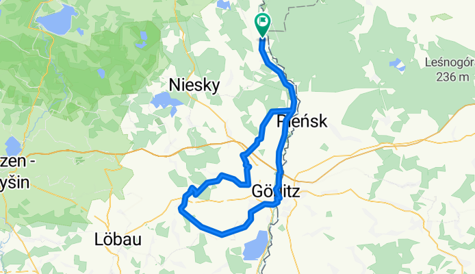
Rothenburg-Görlitz-Reichenbach-Rothenburg
A cycling route starting in Pieńsk, Lower Silesian Voivodeship, Poland.
Overview
About this route
zwischen Mengelsdorf und Königshain ein etwa 2 km langes Stück mit Betonplatten (landwirtschaftlicher Fahrweg
- -:--
- Duration
- 88.1 km
- Distance
- 275 m
- Ascent
- 275 m
- Descent
- ---
- Avg. speed
- ---
- Max. altitude

Route quality
Waytypes & surfaces along the route
Waytypes
Busy road
46 km
(52 %)
Quiet road
17.5 km
(20 %)
Surfaces
Paved
56.1 km
(64 %)
Unpaved
3.2 km
(4 %)
Asphalt
53.3 km
(60 %)
Gravel
2.3 km
(3 %)
Continue with Bikemap
Use, edit, or download this cycling route
You would like to ride Rothenburg-Görlitz-Reichenbach-Rothenburg or customize it for your own trip? Here is what you can do with this Bikemap route:
Free features
- Save this route as favorite or in collections
- Copy & plan your own version of this route
- Split it into stages to create a multi-day tour
- Sync your route with Garmin or Wahoo
Premium features
Free trial for 3 days, or one-time payment. More about Bikemap Premium.
- Navigate this route on iOS & Android
- Export a GPX / KML file of this route
- Create your custom printout (try it for free)
- Download this route for offline navigation
Discover more Premium features.
Get Bikemap PremiumFrom our community
Other popular routes starting in Pieńsk
 Route nach Südstraße
- Distance
- 40 km
- Ascent
- 71 m
- Descent
- 114 m
- Location
- Pieńsk, Lower Silesian Voivodeship, Poland
 Rothenburg -- Bad Muskau Lange Radrunde vom 25. Mai 10:28
- Distance
- 42.4 km
- Ascent
- 144 m
- Descent
- 189 m
- Location
- Pieńsk, Lower Silesian Voivodeship, Poland
 2 etap, Rothenburg - Kromlau - Halbendorf - Bad Muskau - Nowe Czaple
- Distance
- 71.5 km
- Ascent
- 466 m
- Descent
- 473 m
- Location
- Pieńsk, Lower Silesian Voivodeship, Poland
 Pieńsk- Szczecin
- Distance
- 359.3 km
- Ascent
- 157 m
- Descent
- 323 m
- Location
- Pieńsk, Lower Silesian Voivodeship, Poland
 etap3
etap3- Distance
- 45.9 km
- Ascent
- 129 m
- Descent
- 194 m
- Location
- Pieńsk, Lower Silesian Voivodeship, Poland
 Rothenburg - Deulowitzer See
- Distance
- 108.1 km
- Ascent
- 115 m
- Descent
- 208 m
- Location
- Pieńsk, Lower Silesian Voivodeship, Poland
 Oder Neiße Radweg 2020 Tag 2
- Distance
- 40.7 km
- Ascent
- 233 m
- Descent
- 286 m
- Location
- Pieńsk, Lower Silesian Voivodeship, Poland
 Wypad do Mużaka- dzień drugi
- Distance
- 65.5 km
- Ascent
- 1,031 m
- Descent
- 1,070 m
- Location
- Pieńsk, Lower Silesian Voivodeship, Poland
Open it in the app