

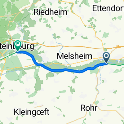
Itinéraire modéré en Illkirch-Graffenstaden
A cycling route starting in Hochfelden, Grand Est, France.
Overview
About this route
- 2 h 3 min
- Duration
- 38.2 km
- Distance
- 31 m
- Ascent
- 60 m
- Descent
- 18.7 km/h
- Avg. speed
- ---
- Max. altitude

Continue with Bikemap
Use, edit, or download this cycling route
You would like to ride Itinéraire modéré en Illkirch-Graffenstaden or customize it for your own trip? Here is what you can do with this Bikemap route:
Free features
- Save this route as favorite or in collections
- Copy & plan your own version of this route
- Sync your route with Garmin or Wahoo
Premium features
Free trial for 3 days, or one-time payment. More about Bikemap Premium.
- Navigate this route on iOS & Android
- Export a GPX / KML file of this route
- Create your custom printout (try it for free)
- Download this route for offline navigation
Discover more Premium features.
Get Bikemap PremiumFrom our community
Other popular routes starting in Hochfelden
 Rue du Général Lebocq 8, Hochfelden nach Rue Jean de Manderscheid 6, Saverne
- Distance
- 20.6 km
- Ascent
- 147 m
- Descent
- 79 m
- Location
- Hochfelden, Grand Est, France
 De Rue du Général Gouraud 18, Hochfelden à Rue du Houblon 22, Kriegsheim
- Distance
- 16.6 km
- Ascent
- 84 m
- Descent
- 55 m
- Location
- Hochfelden, Grand Est, France
 De 22 Rue du Général Lebocq, Hochfelden à 305 Route de Lyon, Illkirch-Graffenstaden
- Distance
- 40.4 km
- Ascent
- 123 m
- Descent
- 153 m
- Location
- Hochfelden, Grand Est, France
 De Rue du Général Gouraud 18, Hochfelden à Rue du Houblon 21, Kriegsheim
- Distance
- 16.6 km
- Ascent
- 80 m
- Descent
- 55 m
- Location
- Hochfelden, Grand Est, France
 Ingenheim to Rue du Vieux Marché aux Grains 22, Strasbourg
- Distance
- 33.7 km
- Ascent
- 139 m
- Descent
- 132 m
- Location
- Hochfelden, Grand Est, France
 Belgique 2022: Day 2
- Distance
- 72.1 km
- Ascent
- 864 m
- Descent
- 840 m
- Location
- Hochfelden, Grand Est, France
 Voie Verte de Brienne-le-Château à Barrière-sur-Seine, Hochfelden nach Voie Verte de Brienne-le-Château à Barrière-sur-Seine, Steinbourg
- Distance
- 13.4 km
- Ascent
- 25 m
- Descent
- 10 m
- Location
- Hochfelden, Grand Est, France
Open it in the app