

Balade Samedi Nadia
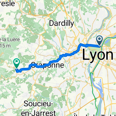
A cycling route starting in Caluire-et-Cuire, Auvergne-Rhône-Alpes, France.
Overview
About this route
- -:--
- Duration
- 37.6 km
- Distance
- 58 m
- Ascent
- 40 m
- Descent
- ---
- Avg. speed
- ---
- Max. altitude

Route quality
Waytypes & surfaces along the route
Waytypes
Cycleway
29.4 km
(78 %)
Path
4.1 km
(11 %)
Surfaces
Paved
22.2 km
(59 %)
Unpaved
9 km
(24 %)
Asphalt
21.8 km
(58 %)
Gravel
5.6 km
(15 %)
Continue with Bikemap
Use, edit, or download this cycling route
You would like to ride Balade Samedi Nadia or customize it for your own trip? Here is what you can do with this Bikemap route:
Free features
- Save this route as favorite or in collections
- Copy & plan your own version of this route
- Sync your route with Garmin or Wahoo
Premium features
Free trial for 3 days, or one-time payment. More about Bikemap Premium.
- Navigate this route on iOS & Android
- Export a GPX / KML file of this route
- Create your custom printout (try it for free)
- Download this route for offline navigation
Discover more Premium features.
Get Bikemap PremiumFrom our community
Other popular routes starting in Caluire-et-Cuire
 30km
30km- Distance
- 33.5 km
- Ascent
- 62 m
- Descent
- 62 m
- Location
- Caluire-et-Cuire, Auvergne-Rhône-Alpes, France
 Lyon - Vaugneray
- Distance
- 17.9 km
- Ascent
- 372 m
- Descent
- 176 m
- Location
- Caluire-et-Cuire, Auvergne-Rhône-Alpes, France
 2 Des bords de Saône aux Monts D'Or
- Distance
- 36.8 km
- Ascent
- 682 m
- Descent
- 661 m
- Location
- Caluire-et-Cuire, Auvergne-Rhône-Alpes, France
 entrainement 2
- Distance
- 145.3 km
- Ascent
- 1,998 m
- Descent
- 2,000 m
- Location
- Caluire-et-Cuire, Auvergne-Rhône-Alpes, France
 4 heures de velo via rhona
- Distance
- 46.1 km
- Ascent
- 134 m
- Descent
- 172 m
- Location
- Caluire-et-Cuire, Auvergne-Rhône-Alpes, France
 a5 Grand tour de l'ouest lyonnais
- Distance
- 125.5 km
- Ascent
- 2,012 m
- Descent
- 2,014 m
- Location
- Caluire-et-Cuire, Auvergne-Rhône-Alpes, France
 5 Circuit des Mts D'Or
- Distance
- 40.1 km
- Ascent
- 813 m
- Descent
- 813 m
- Location
- Caluire-et-Cuire, Auvergne-Rhône-Alpes, France
 Quick bike tour from Villeurbanne to Lyon
- Distance
- 6.3 km
- Ascent
- 55 m
- Descent
- 46 m
- Location
- Caluire-et-Cuire, Auvergne-Rhône-Alpes, France
Open it in the app