

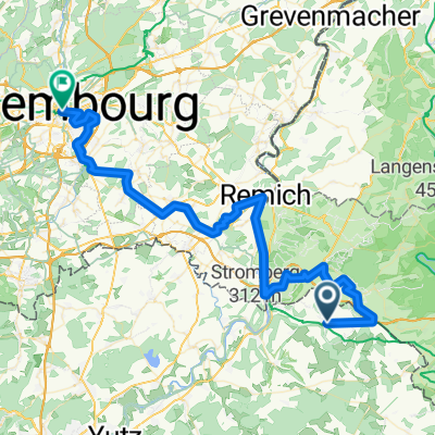
Rettel - Cloef
A cycling route starting in Sierck-les-Bains, Grand Est, France.
Overview
About this route
- 3 h 22 min
- Duration
- 46.4 km
- Distance
- 796 m
- Ascent
- 874 m
- Descent
- 13.8 km/h
- Avg. speed
- ---
- Max. altitude

Route quality
Waytypes & surfaces along the route
Waytypes
Track
19.5 km
(42 %)
Quiet road
8.4 km
(18 %)
Surfaces
Paved
35.7 km
(77 %)
Unpaved
4.6 km
(10 %)
Asphalt
26 km
(56 %)
Paved (undefined)
9.7 km
(21 %)
Continue with Bikemap
Use, edit, or download this cycling route
You would like to ride Rettel - Cloef or customize it for your own trip? Here is what you can do with this Bikemap route:
Free features
- Save this route as favorite or in collections
- Copy & plan your own version of this route
- Sync your route with Garmin or Wahoo
Premium features
Free trial for 3 days, or one-time payment. More about Bikemap Premium.
- Navigate this route on iOS & Android
- Export a GPX / KML file of this route
- Create your custom printout (try it for free)
- Download this route for offline navigation
Discover more Premium features.
Get Bikemap PremiumFrom our community
Other popular routes starting in Sierck-les-Bains
 20130609_Test
- Distance
- 31.1 km
- Ascent
- 377 m
- Descent
- 398 m
- Location
- Sierck-les-Bains, Grand Est, France
 5/ Strumyk przed Rettel - Metz camping
- Distance
- 52.7 km
- Ascent
- 120 m
- Descent
- 95 m
- Location
- Sierck-les-Bains, Grand Est, France
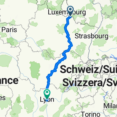 Sierck-les-Bains (57480), Moselle, Grand Est, France - Lyon, Métropole de Lyon, Auvergne-Rhône-Alpes, France
- Distance
- 614.8 km
- Ascent
- 2,056 m
- Descent
- 2,032 m
- Location
- Sierck-les-Bains, Grand Est, France
 Rettel - Cloef
- Distance
- 46.4 km
- Ascent
- 796 m
- Descent
- 874 m
- Location
- Sierck-les-Bains, Grand Est, France
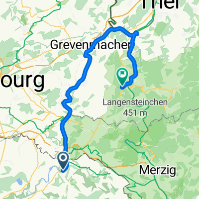
 Manderen - Luxembourg
- Distance
- 66.7 km
- Ascent
- 1,174 m
- Descent
- 1,155 m
- Location
- Sierck-les-Bains, Grand Est, France
 Berg - Waldwisse - Siersburg - Montenach - Berg
- Distance
- 73.8 km
- Ascent
- 630 m
- Descent
- 630 m
- Location
- Sierck-les-Bains, Grand Est, France
 De Sierck-les-Bains à Saarburg
- Distance
- 61.6 km
- Ascent
- 428 m
- Descent
- 369 m
- Location
- Sierck-les-Bains, Grand Est, France
 20130610_Apach_Butzdorf_Ritzing_Montenach_Kirsch_65km
- Distance
- 64.4 km
- Ascent
- 614 m
- Descent
- 614 m
- Location
- Sierck-les-Bains, Grand Est, France
Open it in the app