

Von Bad Liebenwerda nach Forst
A cycling route starting in Bad Liebenwerda, Brandenburg, Germany.
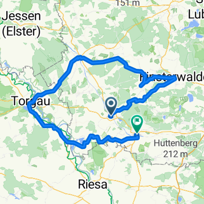
Overview
About this route
In hot weather and with a tailwind (!!) quick ride to Forst. Unfortunately, two punctures in sweltering heat.
- -:--
- Duration
- 115 km
- Distance
- 188 m
- Ascent
- 200 m
- Descent
- ---
- Avg. speed
- ---
- Max. altitude

Route quality
Waytypes & surfaces along the route
Waytypes
Quiet road
27.6 km
(24 %)
Path
26.5 km
(23 %)
Surfaces
Paved
88.6 km
(77 %)
Unpaved
4.6 km
(4 %)
Asphalt
82.8 km
(72 %)
Paved (undefined)
4.6 km
(4 %)
Continue with Bikemap
Use, edit, or download this cycling route
You would like to ride Von Bad Liebenwerda nach Forst or customize it for your own trip? Here is what you can do with this Bikemap route:
Free features
- Save this route as favorite or in collections
- Copy & plan your own version of this route
- Split it into stages to create a multi-day tour
- Sync your route with Garmin or Wahoo
Premium features
Free trial for 3 days, or one-time payment. More about Bikemap Premium.
- Navigate this route on iOS & Android
- Export a GPX / KML file of this route
- Create your custom printout (try it for free)
- Download this route for offline navigation
Discover more Premium features.
Get Bikemap PremiumFrom our community
Other popular routes starting in Bad Liebenwerda
 Herrentagstour 2017 Tag 3.Samstag, 27.05. 17: Senftenberg - Bad - Liebenwerda
- Distance
- 53 km
- Ascent
- 174 m
- Descent
- 159 m
- Location
- Bad Liebenwerda, Brandenburg, Germany
 25 Jahre SUN-SPORT-TEAM die Kurze
- Distance
- 156.3 km
- Ascent
- 166 m
- Descent
- 165 m
- Location
- Bad Liebenwerda, Brandenburg, Germany
 Wasser, Wald und Wackerstein
- Distance
- 36.3 km
- Ascent
- 116 m
- Descent
- 116 m
- Location
- Bad Liebenwerda, Brandenburg, Germany
 25 Jahre SUN-SPORT-TEAM - die lange Luther-Tour
- Distance
- 262.3 km
- Ascent
- 168 m
- Descent
- 170 m
- Location
- Bad Liebenwerda, Brandenburg, Germany
 Day 3
Day 3- Distance
- 144.7 km
- Ascent
- 253 m
- Descent
- 313 m
- Location
- Bad Liebenwerda, Brandenburg, Germany
 Landschaft von Menschenhand
- Distance
- 35.3 km
- Ascent
- 99 m
- Descent
- 99 m
- Location
- Bad Liebenwerda, Brandenburg, Germany
 2.Tag, Bad Liebenwerda- Cottbus
- Distance
- 103.8 km
- Ascent
- 214 m
- Descent
- 223 m
- Location
- Bad Liebenwerda, Brandenburg, Germany
 11.05.2013 Naturparktour
- Distance
- 69.8 km
- Ascent
- 193 m
- Descent
- 195 m
- Location
- Bad Liebenwerda, Brandenburg, Germany
Open it in the app