

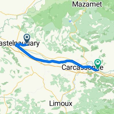
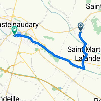
Itinéraire modéré en Laurabuc
A cycling route starting in Saint-Martin-Lalande, Occitanie, France.
Overview
About this route
- 1 h 52 min
- Duration
- 39.8 km
- Distance
- 438 m
- Ascent
- 412 m
- Descent
- 21.3 km/h
- Avg. speed
- ---
- Max. altitude

Route quality
Waytypes & surfaces along the route
Waytypes
Road
26.6 km
(67 %)
Quiet road
3.6 km
(9 %)
Undefined
9.5 km
(24 %)
Surfaces
Paved
9.5 km
(24 %)
Asphalt
9.5 km
(24 %)
Undefined
30.2 km
(76 %)
Continue with Bikemap
Use, edit, or download this cycling route
You would like to ride Itinéraire modéré en Laurabuc or customize it for your own trip? Here is what you can do with this Bikemap route:
Free features
- Save this route as favorite or in collections
- Copy & plan your own version of this route
- Sync your route with Garmin or Wahoo
Premium features
Free trial for 3 days, or one-time payment. More about Bikemap Premium.
- Navigate this route on iOS & Android
- Export a GPX / KML file of this route
- Create your custom printout (try it for free)
- Download this route for offline navigation
Discover more Premium features.
Get Bikemap PremiumFrom our community
Other popular routes starting in Saint-Martin-Lalande
 Castelnaudary LampyNeuf
- Distance
- 53 km
- Ascent
- 794 m
- Descent
- 776 m
- Location
- Saint-Martin-Lalande, Occitanie, France
 Domaine de la Capelle, Saint-Martin-Lalande to Trèbes
- Distance
- 52.8 km
- Ascent
- 147 m
- Descent
- 221 m
- Location
- Saint-Martin-Lalande, Occitanie, France
 De Chemin du Moulin 5, Pexiora à Rue Résidence la Cressonnière 6, Pexiora
- Distance
- 52.5 km
- Ascent
- 152 m
- Descent
- 152 m
- Location
- Saint-Martin-Lalande, Occitanie, France
 14 Apr 2015 11:34
- Distance
- 2.6 km
- Ascent
- 56 m
- Descent
- 48 m
- Location
- Saint-Martin-Lalande, Occitanie, France
 Itinéraire modéré en Laurabuc
- Distance
- 39.8 km
- Ascent
- 438 m
- Descent
- 412 m
- Location
- Saint-Martin-Lalande, Occitanie, France
 14_Sarrazi Toulouse
- Distance
- 74.2 km
- Ascent
- 265 m
- Descent
- 278 m
- Location
- Saint-Martin-Lalande, Occitanie, France
 Tappa 9 FaunTour2k22
- Distance
- 105.7 km
- Ascent
- 258 m
- Descent
- 294 m
- Location
- Saint-Martin-Lalande, Occitanie, France
 Domaine de la Capelle, Saint-Martin-Lalande to Place de la Gare, Castelnaudary
- Distance
- 9.6 km
- Ascent
- 67 m
- Descent
- 64 m
- Location
- Saint-Martin-Lalande, Occitanie, France
Open it in the app