

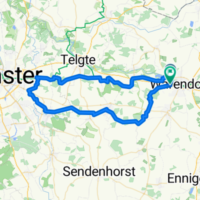
Warendorf - Versmold - Warendorf
A cycling route starting in Warendorf, North Rhine-Westphalia, Germany.
Overview
About this route
- -:--
- Duration
- 45.8 km
- Distance
- 51 m
- Ascent
- 49 m
- Descent
- ---
- Avg. speed
- ---
- Max. altitude
Route quality
Waytypes & surfaces along the route
Waytypes
Quiet road
32.1 km
(70 %)
Path
6 km
(13 %)
Surfaces
Paved
27 km
(59 %)
Unpaved
8.2 km
(18 %)
Asphalt
19.7 km
(43 %)
Paved (undefined)
7.3 km
(16 %)
Continue with Bikemap
Use, edit, or download this cycling route
You would like to ride Warendorf - Versmold - Warendorf or customize it for your own trip? Here is what you can do with this Bikemap route:
Free features
- Save this route as favorite or in collections
- Copy & plan your own version of this route
- Sync your route with Garmin or Wahoo
Premium features
Free trial for 3 days, or one-time payment. More about Bikemap Premium.
- Navigate this route on iOS & Android
- Export a GPX / KML file of this route
- Create your custom printout (try it for free)
- Download this route for offline navigation
Discover more Premium features.
Get Bikemap PremiumFrom our community
Other popular routes starting in Warendorf
 Route in Warendorf
- Distance
- 55.8 km
- Ascent
- 181 m
- Descent
- 179 m
- Location
- Warendorf, North Rhine-Westphalia, Germany
 1.Mai Tour 2009
- Distance
- 37.8 km
- Ascent
- 56 m
- Descent
- 55 m
- Location
- Warendorf, North Rhine-Westphalia, Germany
 Freckenhorst-Müssingen-Telgte-Everswinkel-Cafe Eichenhof-Freckenhorst
- Distance
- 45.5 km
- Ascent
- 142 m
- Descent
- 141 m
- Location
- Warendorf, North Rhine-Westphalia, Germany
 Warendorf-Telgte-Pleistermühle-Everswinkel-Freckenhorst-Warendorf
- Distance
- 59.7 km
- Ascent
- 137 m
- Descent
- 134 m
- Location
- Warendorf, North Rhine-Westphalia, Germany
 Warendorf- Telgte und zurück
- Distance
- 40.5 km
- Ascent
- 58 m
- Descent
- 62 m
- Location
- Warendorf, North Rhine-Westphalia, Germany
 Warendorf-Vinnenberg-Ostbevern-Telgte-Warendorf
- Distance
- 56.5 km
- Ascent
- 146 m
- Descent
- 144 m
- Location
- Warendorf, North Rhine-Westphalia, Germany
 Liener Pass von WAF 55km
- Distance
- 55.8 km
- Ascent
- 214 m
- Descent
- 212 m
- Location
- Warendorf, North Rhine-Westphalia, Germany
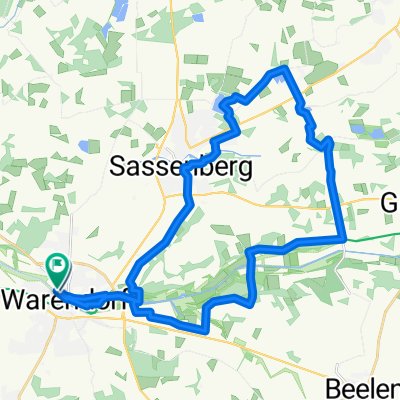 Warendorf - Sassenberg - Rundtour
- Distance
- 30.6 km
- Ascent
- 81 m
- Descent
- 78 m
- Location
- Warendorf, North Rhine-Westphalia, Germany
Open it in the app