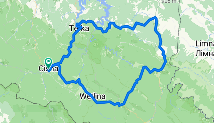
Pętla bieszczadzka
A cycling route starting in Cisna, Subcarpathian Voivodeship, Poland.
Overview
About this route
- -:--
- Duration
- 100.8 km
- Distance
- 1,157 m
- Ascent
- 1,156 m
- Descent
- ---
- Avg. speed
- ---
- Max. altitude
Route quality
Waytypes & surfaces along the route
Waytypes
Road
29.2 km
(29 %)
Quiet road
1 km
(1 %)
Undefined
70.6 km
(70 %)
Surfaces
Paved
98.8 km
(98 %)
Asphalt
98.8 km
(98 %)
Undefined
2 km
(2 %)
Continue with Bikemap
Use, edit, or download this cycling route
You would like to ride Pętla bieszczadzka or customize it for your own trip? Here is what you can do with this Bikemap route:
Free features
- Save this route as favorite or in collections
- Copy & plan your own version of this route
- Split it into stages to create a multi-day tour
- Sync your route with Garmin or Wahoo
Premium features
Free trial for 3 days, or one-time payment. More about Bikemap Premium.
- Navigate this route on iOS & Android
- Export a GPX / KML file of this route
- Create your custom printout (try it for free)
- Download this route for offline navigation
Discover more Premium features.
Get Bikemap PremiumFrom our community
Other popular routes starting in Cisna
Long bike tour from Pastviny to Kalnica- Distance
- 31.2 km
- Ascent
- 559 m
- Descent
- 557 m
- Location
- Cisna, Subcarpathian Voivodeship, Poland
Pętla bieszczadzka- Distance
- 100.8 km
- Ascent
- 1,157 m
- Descent
- 1,156 m
- Location
- Cisna, Subcarpathian Voivodeship, Poland
ride from Pastviny to Kalnica- Distance
- 21.2 km
- Ascent
- 305 m
- Descent
- 303 m
- Location
- Cisna, Subcarpathian Voivodeship, Poland
Cisna - Fereczata i OkrÄ…glik- Distance
- 34 km
- Ascent
- 790 m
- Descent
- 790 m
- Location
- Cisna, Subcarpathian Voivodeship, Poland
Dookoła Masywu Hyrlatej.- Distance
- 29.1 km
- Ascent
- 491 m
- Descent
- 492 m
- Location
- Cisna, Subcarpathian Voivodeship, Poland
Caryńska pętla- Distance
- 92.6 km
- Ascent
- 927 m
- Descent
- 928 m
- Location
- Cisna, Subcarpathian Voivodeship, Poland
k pod Honem- Distance
- 13.6 km
- Ascent
- 460 m
- Descent
- 469 m
- Location
- Cisna, Subcarpathian Voivodeship, Poland
Stakcin, Słowacja- Distance
- 28.8 km
- Ascent
- 212 m
- Descent
- 654 m
- Location
- Cisna, Subcarpathian Voivodeship, Poland
Open it in the app


