
Zigaretten holen
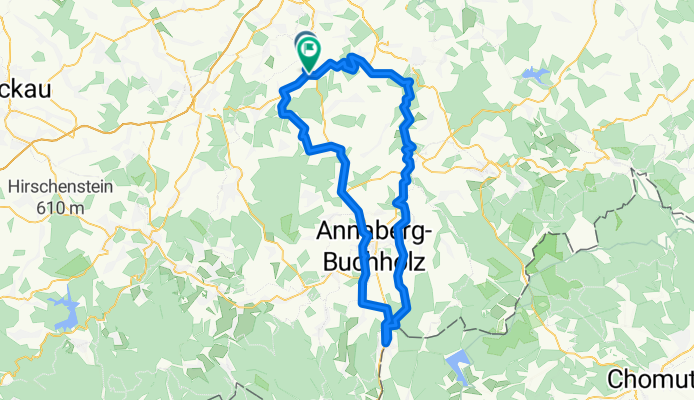
A cycling route starting in Burkhardtsdorf, Saxony, Germany.
Overview
About this route
Eine meiner Strecken zum Zigaretten holen ... Bei den Höhenmetern lohnt sich das Ganze erst am 2 Stangen. Nach Einrollen im Zwönitztal geht´s Auerbach hoch - am Anfang kein Problem. Über Jahnsdorf runter nach Thum, dann (leider) auf die B95. Geht aber. Die Abfahrt von Schönfeld ist seitenwindempfindlich. Über Frohnauer Hammer geht´s ins Sehmatal - der letzte Abschnitt dahin ist kurzfristig beschissen asphaltiert, aber schnell vorbei. Durch Sehma geht´s fast ganz durch, dann links weg. Die folgende Steigung ist nervtötend lang, und erst zu Ende, wenn die B 95 erreicht ist. Die paar km bis Bärenstein (Seitenwind!!) machenklar, daß das mit dem Sehmatal doch keine sooo schlechte Idee war. Über der Grenze kommen wir dann zum eigentlichen Zweck der Tour ;-). Zurück geht´s ins Oelsa-Tal, als Rast empfehle ich die Brettmühle. Der Rest fährt sich recht angenehm - mit wenigen Ausnahmen. Die letzte Klippe wartet in Weißbach, dann trudelt es sich im Zwönitztal ruhig aus.
- -:--
- Duration
- 89.2 km
- Distance
- 789 m
- Ascent
- 837 m
- Descent
- ---
- Avg. speed
- ---
- Max. altitude

Route quality
Waytypes & surfaces along the route
Waytypes
Road
11.6 km
(13 %)
Quiet road
8.9 km
(10 %)
Surfaces
Paved
81.2 km
(91 %)
Unpaved
2.7 km
(3 %)
Asphalt
80.3 km
(90 %)
Paved (undefined)
0.9 km
(1 %)
Continue with Bikemap
Use, edit, or download this cycling route
You would like to ride Zigaretten holen or customize it for your own trip? Here is what you can do with this Bikemap route:
Free features
- Save this route as favorite or in collections
- Copy & plan your own version of this route
- Split it into stages to create a multi-day tour
- Sync your route with Garmin or Wahoo
Premium features
Free trial for 3 days, or one-time payment. More about Bikemap Premium.
- Navigate this route on iOS & Android
- Export a GPX / KML file of this route
- Create your custom printout (try it for free)
- Download this route for offline navigation
Discover more Premium features.
Get Bikemap PremiumFrom our community
Other popular routes starting in Burkhardtsdorf
 auersberg - fichtelberg
- Distance
- 145 km
- Ascent
- 1,481 m
- Descent
- 1,481 m
- Location
- Burkhardtsdorf, Saxony, Germany
 hieckis
- Distance
- 86.5 km
- Ascent
- 884 m
- Descent
- 1,045 m
- Location
- Burkhardtsdorf, Saxony, Germany
 Amselring 14, Burkhardtsdorf nach Thumer Straße 71, Geyer
- Distance
- 17 km
- Ascent
- 459 m
- Descent
- 242 m
- Location
- Burkhardtsdorf, Saxony, Germany
 Burkhardtsdorf - Fichtelberg - Plattenberg
- Distance
- 117.2 km
- Ascent
- 1,520 m
- Descent
- 1,419 m
- Location
- Burkhardtsdorf, Saxony, Germany
 Zigaretten holen
- Distance
- 89.2 km
- Ascent
- 789 m
- Descent
- 837 m
- Location
- Burkhardtsdorf, Saxony, Germany
 Burkhardtsdorf-Scheibenberg-Burkhardtsdorf
- Distance
- 56 km
- Ascent
- 870 m
- Descent
- 870 m
- Location
- Burkhardtsdorf, Saxony, Germany
 Klaffenbach Adorf Meinersdorf Klaffenbach
- Distance
- 16.2 km
- Ascent
- 373 m
- Descent
- 373 m
- Location
- Burkhardtsdorf, Saxony, Germany
 Burkhardtsdorf - Hüttstattmühle - Hirtstein
- Distance
- 106.2 km
- Ascent
- 1,408 m
- Descent
- 1,420 m
- Location
- Burkhardtsdorf, Saxony, Germany
Open it in the app