

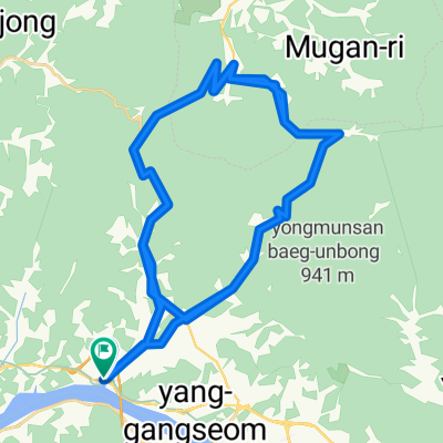
JeePyeong - 88km
A cycling route starting in Yangp'yŏng, Gyeonggi-do, South Korea.
Overview
About this route
- -:--
- Duration
- 88.5 km
- Distance
- 849 m
- Ascent
- 850 m
- Descent
- ---
- Avg. speed
- ---
- Max. altitude

Route quality
Waytypes & surfaces along the route
Waytypes
Busy road
44.5 km
(50 %)
Road
19.6 km
(22 %)
Surfaces
Paved
17.7 km
(20 %)
Asphalt
15.8 km
(18 %)
Concrete
1.5 km
(2 %)
Continue with Bikemap
Use, edit, or download this cycling route
You would like to ride JeePyeong - 88km or customize it for your own trip? Here is what you can do with this Bikemap route:
Free features
- Save this route as favorite or in collections
- Copy & plan your own version of this route
- Split it into stages to create a multi-day tour
- Sync your route with Garmin or Wahoo
Premium features
Free trial for 3 days, or one-time payment. More about Bikemap Premium.
- Navigate this route on iOS & Android
- Export a GPX / KML file of this route
- Create your custom printout (try it for free)
- Download this route for offline navigation
Discover more Premium features.
Get Bikemap PremiumFrom our community
Other popular routes starting in Yangp'yŏng
 Day#1
Day#1- Distance
- 77.2 km
- Ascent
- 938 m
- Descent
- 977 m
- Location
- Yangp'yŏng, Gyeonggi-do, South Korea
 JeePyeong - 88km
- Distance
- 88.5 km
- Ascent
- 849 m
- Descent
- 850 m
- Location
- Yangp'yŏng, Gyeonggi-do, South Korea
 asin-seoljimae-yumyeong loop
- Distance
- 63.7 km
- Ascent
- 1,885 m
- Descent
- 1,890 m
- Location
- Yangp'yŏng, Gyeonggi-do, South Korea
 여양로, 여주시에서 왕대리, 여주시까지
- Distance
- 13.5 km
- Ascent
- 39 m
- Descent
- 32 m
- Location
- Yangp'yŏng, Gyeonggi-do, South Korea
 양서면 496-8 ~ 조안면 285-6
- Distance
- 20.4 km
- Ascent
- 162 m
- Descent
- 187 m
- Location
- Yangp'yŏng, Gyeonggi-do, South Korea
 Day#2
Day#2- Distance
- 61.5 km
- Ascent
- 703 m
- Descent
- 710 m
- Location
- Yangp'yŏng, Gyeonggi-do, South Korea
 양평군에서 양평군까지
- Distance
- 30.4 km
- Ascent
- 342 m
- Descent
- 345 m
- Location
- Yangp'yŏng, Gyeonggi-do, South Korea
 양평-양수역-벗고개-서후고개-문호리-문안고개-외서면-남이섬 86km 1030m
- Distance
- 86.1 km
- Ascent
- 642 m
- Descent
- 597 m
- Location
- Yangp'yŏng, Gyeonggi-do, South Korea
Open it in the app