

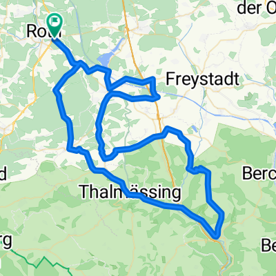
Roth-Linden
A cycling route starting in Roth, Bavaria, Germany.
Overview
About this route
- 2 h 2 min
- Duration
- 36.4 km
- Distance
- 335 m
- Ascent
- 168 m
- Descent
- 18 km/h
- Avg. speed
- ---
- Max. altitude
Route photos

Route quality
Waytypes & surfaces along the route
Waytypes
Track
15.7 km
(43 %)
Quiet road
7.6 km
(21 %)
Surfaces
Paved
24.4 km
(67 %)
Unpaved
6.9 km
(19 %)
Asphalt
20.4 km
(56 %)
Gravel
6.2 km
(17 %)
Continue with Bikemap
Use, edit, or download this cycling route
You would like to ride Roth-Linden or customize it for your own trip? Here is what you can do with this Bikemap route:
Free features
- Save this route as favorite or in collections
- Copy & plan your own version of this route
- Sync your route with Garmin or Wahoo
Premium features
Free trial for 3 days, or one-time payment. More about Bikemap Premium.
- Navigate this route on iOS & Android
- Export a GPX / KML file of this route
- Create your custom printout (try it for free)
- Download this route for offline navigation
Discover more Premium features.
Get Bikemap PremiumFrom our community
Other popular routes starting in Roth
 rothtour
- Distance
- 43.3 km
- Ascent
- 299 m
- Descent
- 300 m
- Location
- Roth, Bavaria, Germany
 trailmix
- Distance
- 15.7 km
- Ascent
- 1,036 m
- Descent
- 1,035 m
- Location
- Roth, Bavaria, Germany
 Roth Cycling
- Distance
- 14.9 km
- Ascent
- 112 m
- Descent
- 109 m
- Location
- Roth, Bavaria, Germany
 Fränkischer-Wasserradweg
- Distance
- 353.7 km
- Ascent
- 2,584 m
- Descent
- 2,585 m
- Location
- Roth, Bavaria, Germany
 Challenge Roth
- Distance
- 92.2 km
- Ascent
- 502 m
- Descent
- 501 m
- Location
- Roth, Bavaria, Germany
 Rothsee Tour
- Distance
- 35.6 km
- Ascent
- 216 m
- Descent
- 220 m
- Location
- Roth, Bavaria, Germany
 Challenge Roth
- Distance
- 92.2 km
- Ascent
- 487 m
- Descent
- 487 m
- Location
- Roth, Bavaria, Germany
 Challenge Roth - Bike
- Distance
- 92.2 km
- Ascent
- 485 m
- Descent
- 486 m
- Location
- Roth, Bavaria, Germany
Open it in the app