

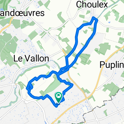
Campagne Collonges - Bellerive
A cycling route starting in Puplinge, Canton of Geneva, Switzerland.
Overview
About this route
- -:--
- Duration
- 23.1 km
- Distance
- 169 m
- Ascent
- 170 m
- Descent
- ---
- Avg. speed
- ---
- Max. altitude
Route quality
Waytypes & surfaces along the route
Waytypes
Quiet road
10.6 km
(46 %)
Road
8.5 km
(37 %)
Surfaces
Paved
19.2 km
(83 %)
Asphalt
16.6 km
(72 %)
Paved (undefined)
1.8 km
(8 %)
Continue with Bikemap
Use, edit, or download this cycling route
You would like to ride Campagne Collonges - Bellerive or customize it for your own trip? Here is what you can do with this Bikemap route:
Free features
- Save this route as favorite or in collections
- Copy & plan your own version of this route
- Sync your route with Garmin or Wahoo
Premium features
Free trial for 3 days, or one-time payment. More about Bikemap Premium.
- Navigate this route on iOS & Android
- Export a GPX / KML file of this route
- Create your custom printout (try it for free)
- Download this route for offline navigation
Discover more Premium features.
Get Bikemap PremiumFrom our community
Other popular routes starting in Puplinge
 60km Rundfahrt relativ flach
- Distance
- 58.7 km
- Ascent
- 235 m
- Descent
- 234 m
- Location
- Puplinge, Canton of Geneva, Switzerland
 tour du salève
- Distance
- 59.9 km
- Ascent
- 1,159 m
- Descent
- 1,049 m
- Location
- Puplinge, Canton of Geneva, Switzerland
 Eté 2017 - Choulex - San Sebastian
- Distance
- 1,174.1 km
- Ascent
- 3,666 m
- Descent
- 4,037 m
- Location
- Puplinge, Canton of Geneva, Switzerland
 Choulex - St Blaise - Croisette - Veyrier - Thônex - Choule
- Distance
- 73.4 km
- Ascent
- 1,055 m
- Descent
- 1,056 m
- Location
- Puplinge, Canton of Geneva, Switzerland
 deux fois le Jura
- Distance
- 97.1 km
- Ascent
- 1,821 m
- Descent
- 1,723 m
- Location
- Puplinge, Canton of Geneva, Switzerland
 Chemin des Agrimenseurs, Thônex à Chemin des Sillons 7, Thônex
- Distance
- 7.1 km
- Ascent
- 7 m
- Descent
- 7 m
- Location
- Puplinge, Canton of Geneva, Switzerland
 Avec Stéph et Aïmi
- Distance
- 20.4 km
- Ascent
- 134 m
- Descent
- 133 m
- Location
- Puplinge, Canton of Geneva, Switzerland
 Juillet 2013
- Distance
- 110.7 km
- Ascent
- 592 m
- Descent
- 783 m
- Location
- Puplinge, Canton of Geneva, Switzerland
Open it in the app