

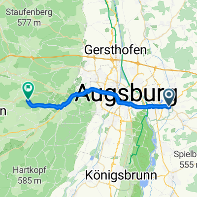
Oxenweg_FDB_Altomünster
A cycling route starting in Friedberg, Bavaria, Germany.
Overview
About this route
Relaxed loop for a lovely day in the region. The route mainly follows quiet roads or bike paths. If you time it right, you can stop for lunch at the Maierbräu brewery inn. The apple strudel there is especially recommended.
- -:--
- Duration
- 54.9 km
- Distance
- 381 m
- Ascent
- 381 m
- Descent
- ---
- Avg. speed
- ---
- Max. altitude

Route quality
Waytypes & surfaces along the route
Waytypes
Quiet road
31.8 km
(58 %)
Track
9.9 km
(18 %)
Surfaces
Paved
40.1 km
(73 %)
Unpaved
7.7 km
(14 %)
Asphalt
39 km
(71 %)
Gravel
4.9 km
(9 %)
Continue with Bikemap
Use, edit, or download this cycling route
You would like to ride Oxenweg_FDB_Altomünster or customize it for your own trip? Here is what you can do with this Bikemap route:
Free features
- Save this route as favorite or in collections
- Copy & plan your own version of this route
- Sync your route with Garmin or Wahoo
Premium features
Free trial for 3 days, or one-time payment. More about Bikemap Premium.
- Navigate this route on iOS & Android
- Export a GPX / KML file of this route
- Create your custom printout (try it for free)
- Download this route for offline navigation
Discover more Premium features.
Get Bikemap PremiumFrom our community
Other popular routes starting in Friedberg
 Aux 40k 350h
- Distance
- 39.8 km
- Ascent
- 123 m
- Descent
- 125 m
- Location
- Friedberg, Bavaria, Germany
 Friedberg / Rommelsried
- Distance
- 24 km
- Ascent
- 159 m
- Descent
- 169 m
- Location
- Friedberg, Bavaria, Germany
 Kirchenroute FDB-Süd
- Distance
- 27 km
- Ascent
- 150 m
- Descent
- 150 m
- Location
- Friedberg, Bavaria, Germany
 Neue Badetour
- Distance
- 25.1 km
- Ascent
- 84 m
- Descent
- 84 m
- Location
- Friedberg, Bavaria, Germany
 Rund um Augsburg
- Distance
- 54.9 km
- Ascent
- 429 m
- Descent
- 445 m
- Location
- Friedberg, Bavaria, Germany
 Friedberger Osten
- Distance
- 25.4 km
- Ascent
- 238 m
- Descent
- 241 m
- Location
- Friedberg, Bavaria, Germany
 Lechtrails
- Distance
- 44.5 km
- Ascent
- 135 m
- Descent
- 135 m
- Location
- Friedberg, Bavaria, Germany
 Sozialstation Augsburg am Lech über Wiesen und Felder nach zurück Augsburg
- Distance
- 66.4 km
- Ascent
- 918 m
- Descent
- 916 m
- Location
- Friedberg, Bavaria, Germany
Open it in the app