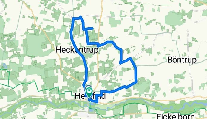
Kapellentour in Herzfeld (Denkmaltag 2019)
A cycling route starting in Bad Sassendorf, North Rhine-Westphalia, Germany.
Overview
About this route
<p>Ss. Anna and Joachim Chapel in Heckentrup (on the LandesGartenSchau Route), St. Anna Chapel in Schachtrup (Hof Uelentrup), St. Antonius Chapel in Rassenhövel, Evangelical Chapel of Thanksgiving in Herzfeld</p>
Translated, show original (German)- -:--
- Duration
- 17.4 km
- Distance
- 44 m
- Ascent
- 45 m
- Descent
- ---
- Avg. speed
- ---
- Max. altitude
Route quality
Waytypes & surfaces along the route
Waytypes
Quiet road
13.4 km
(77 %)
Road
1.6 km
(9 %)
Surfaces
Paved
5.7 km
(33 %)
Asphalt
5.7 km
(33 %)
Undefined
11.7 km
(67 %)
Route highlights
Points of interest along the route
Point of interest after 2.7 km
Ss. Anna und Joachim Kapelle Heckentrup
Point of interest after 6.2 km
St. Anna Kapelle Schachtrup (Hof Uelentrup)
Point of interest after 11.1 km
St. Antonius Kapelle Rassenhövel
Point of interest after 17.1 km
Ev. Dankeskapelle Herzfeld
Continue with Bikemap
Use, edit, or download this cycling route
You would like to ride Kapellentour in Herzfeld (Denkmaltag 2019) or customize it for your own trip? Here is what you can do with this Bikemap route:
Free features
- Save this route as favorite or in collections
- Copy & plan your own version of this route
- Sync your route with Garmin or Wahoo
Premium features
Free trial for 3 days, or one-time payment. More about Bikemap Premium.
- Navigate this route on iOS & Android
- Export a GPX / KML file of this route
- Create your custom printout (try it for free)
- Download this route for offline navigation
Discover more Premium features.
Get Bikemap PremiumFrom our community
Other popular routes starting in Bad Sassendorf
- Juli 2010 (I): "Hellweg-Radio-Bäderroute"
- Distance
- 56.5 km
- Ascent
- 78 m
- Descent
- 76 m
- Location
- Bad Sassendorf, North Rhine-Westphalia, Germany
- 31km-Rund um Soest
- Distance
- 31.2 km
- Ascent
- 145 m
- Descent
- 145 m
- Location
- Bad Sassendorf, North Rhine-Westphalia, Germany
- Tour 4 - Durch Börde und Münsterland (türkis)
- Distance
- 23.8 km
- Ascent
- 49 m
- Descent
- 46 m
- Location
- Bad Sassendorf, North Rhine-Westphalia, Germany
- Mai 2011: "Durch Börde und Münsterland - Flüsse, Auen und Schlösser"
- Distance
- 44.2 km
- Ascent
- 75 m
- Descent
- 77 m
- Location
- Bad Sassendorf, North Rhine-Westphalia, Germany
- Tour 1 - Durch Börde und Münsterland (gelb)
- Distance
- 59.3 km
- Ascent
- 81 m
- Descent
- 80 m
- Location
- Bad Sassendorf, North Rhine-Westphalia, Germany
- Sonntagsnachmittagstour von Bad Sassendorf nach Lippetal 29 JUL 2020.gpx
- Distance
- 29.9 km
- Ascent
- 98 m
- Descent
- 99 m
- Location
- Bad Sassendorf, North Rhine-Westphalia, Germany
- Entdeckertour Lippetal - WasserWegeWinkel
- Distance
- 32.3 km
- Ascent
- 41 m
- Descent
- 44 m
- Location
- Bad Sassendorf, North Rhine-Westphalia, Germany
- Tour 3 - Durch Börde und Münsterland (grün)
- Distance
- 52.5 km
- Ascent
- 92 m
- Descent
- 89 m
- Location
- Bad Sassendorf, North Rhine-Westphalia, Germany
Open it in the app