

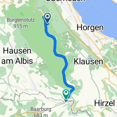
Sihlwald - Grünmattstrasse
A cycling route starting in Oberrieden / Berg, Canton of Zurich, Switzerland.
Overview
About this route
- 1 h 6 min
- Duration
- 15.4 km
- Distance
- 142 m
- Ascent
- 625 m
- Descent
- 14 km/h
- Avg. speed
- ---
- Max. altitude
Route quality
Waytypes & surfaces along the route
Waytypes
Path
4.8 km
(31 %)
Quiet road
4.6 km
(30 %)
Surfaces
Paved
10 km
(65 %)
Unpaved
5.3 km
(34 %)
Asphalt
10 km
(65 %)
Gravel
4.9 km
(32 %)
Continue with Bikemap
Use, edit, or download this cycling route
You would like to ride Sihlwald - Grünmattstrasse or customize it for your own trip? Here is what you can do with this Bikemap route:
Free features
- Save this route as favorite or in collections
- Copy & plan your own version of this route
- Sync your route with Garmin or Wahoo
Premium features
Free trial for 3 days, or one-time payment. More about Bikemap Premium.
- Navigate this route on iOS & Android
- Export a GPX / KML file of this route
- Create your custom printout (try it for free)
- Download this route for offline navigation
Discover more Premium features.
Get Bikemap PremiumFrom our community
Other popular routes starting in Oberrieden / Berg
 Gerade Fahrt in Horgen
- Distance
- 10.7 km
- Ascent
- 286 m
- Descent
- 345 m
- Location
- Oberrieden / Berg, Canton of Zurich, Switzerland
 Sihlwald - Grünmattstrasse
- Distance
- 15.4 km
- Ascent
- 142 m
- Descent
- 625 m
- Location
- Oberrieden / Berg, Canton of Zurich, Switzerland
 Alte Sihltalstrasse 31, Sihlwald nach Stadthausquai 17, Zürich
- Distance
- 13.9 km
- Ascent
- 151 m
- Descent
- 225 m
- Location
- Oberrieden / Berg, Canton of Zurich, Switzerland
- Tabletenstrasse, Sihlwald nach Sihluferweg, Gattikon
- Distance
- 1 km
- Ascent
- 0 m
- Descent
- 3 m
- Location
- Oberrieden / Berg, Canton of Zurich, Switzerland
 Svajciarsko 3
- Distance
- 121.3 km
- Ascent
- 1,401 m
- Descent
- 1,482 m
- Location
- Oberrieden / Berg, Canton of Zurich, Switzerland
 VCA VCH Sihlwald - Höchi
- Distance
- 9 km
- Ascent
- 363 m
- Descent
- 125 m
- Location
- Oberrieden / Berg, Canton of Zurich, Switzerland
 BRM 600 - 6
- Distance
- 94 km
- Ascent
- 401 m
- Descent
- 477 m
- Location
- Oberrieden / Berg, Canton of Zurich, Switzerland
 Tabletenstrasse, Sihlwald to Zugerstrasse, Sihlbrugg
- Distance
- 7.4 km
- Ascent
- 84 m
- Descent
- 38 m
- Location
- Oberrieden / Berg, Canton of Zurich, Switzerland
Open it in the app